最小化 最新宪章启动

Charter activations

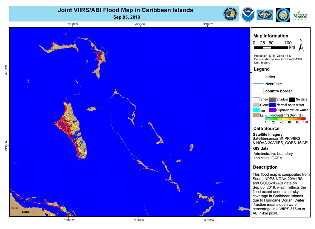
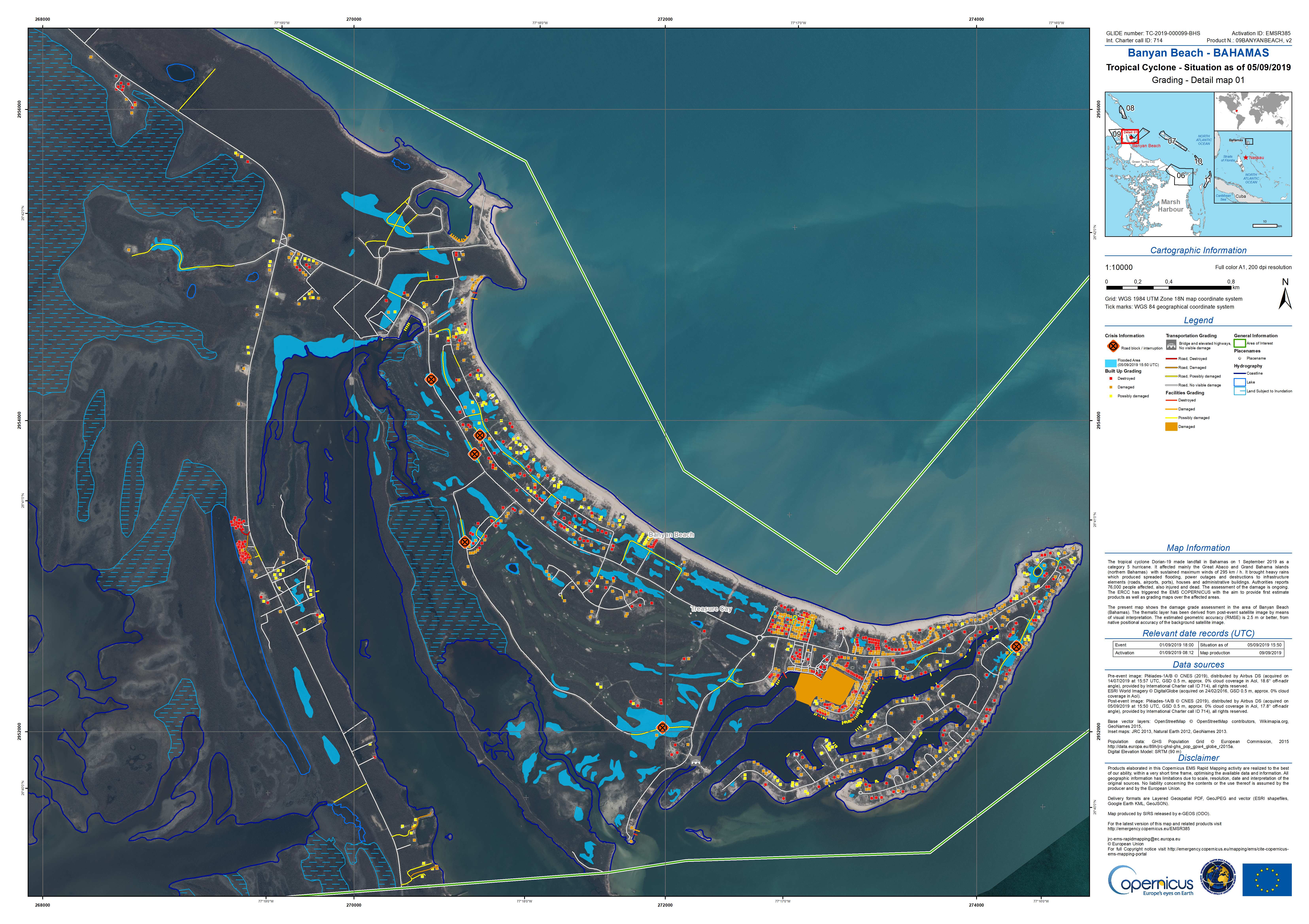
Hurricane Dorian in Bahamas

Hurricane Dorian made landfall in the Bahamas on 1 September as a Category 5 storm bringing strong wind speeds of 185mph and heavy rainfall. At least 20 people have been killed with many more missing, injured and displaced.

The Abaco Islands and Grand Bahama, in the north of the archipelago were battered by the storm for 2 days which decimated whole areas, leaving houses without roofs, scattered debris and flooding as up to 35 inches of rain fell.

The International Red Cross estimated 45% of homes (13,000) on Grand Bahama and the Abacos have been destroyed. Bahamas Prime Minister Hubert Minnis described the storm as a "historic tragedy" for the archipelago.

Rescue teams reached the worst affected areas areas of the northern Bahamas to begin search, rescue and recovery. UN officials reported 60,000 people will require food aid and clean water.

After battering the Bahamas, Dorian moved north towards the east coast of the USA, still carrying wind speeds of 115 mph. South Carolina is preparing for a record storm surge as Dorian is expected to make landfall on 6 September.

Related News and Resources

事件类型:cyclone
事件地点:Bahamas
启动宪章的日期:2019-09-04
宪章启动时间:14:08
宪章启动时区:UTC-05:00
宪章要求者:EROS on behalf of The Bahamas National Emergency Management Administration (NEMA)
启动ID:620
项目经理:University of Louisiana at Lafayette

Products

Marine pollution surveillance, Bahamas

版权: © Planet (2019)
Map produced by NOAA

Information about the Product

已获得: 17/09/2019

源: PlanetScope

Marine pollution surveillance, Bahamas

版权: © All rights reserved ROSCOSMOS 2019
Map produced by NOAA

Information about the Product

已获得: 17/09/2019

源: Kanopus-V

Damage assessment in the Bahamas

版权: © 2019 Maxar Technologies Inc. - All rights reserved
Map produced by NOAA

Information about the Product

已获得: 07/09/2019

源: WorldView-3

Flood assessment in the Bahamas

版权: © Contains modified Copernicus Sentinel data (2018)
Map produced by NOAA

Information about the Product

已获得: 14/09/2019

源: Sentinel-1

Flood impact in the Caribbean Islands due to Hurricane Dorian

版权: NOAA (2019)
Map produced by NOAA

Information about the Product

已获得: 09/09/2019 to 11/09/2019

源: Suomi NPP / NOAA-20

Flood assessment in the Bahamas

Download the full product

版权: © Copernicus Sentinel data (2019)
Map produced by NOAA

Information about the Product

已获得: 10/09/2019

源: Sentinel-1

Flood impact in the Caribbean Islands due to Hurricane Dorian

版权: NOAA (2019)
Map produced by NOAA

Information about the Product

已获得: 05/09/2019

源: Suomi NPP, NOAA-20 and GOES-16

Flood impact in the Caribbean Islands due to Hurricane Dorian in the Bahamas.

版权: NOAA (2019)
Map produced by NOAA

Information about the Product

已获得: 04/09/2019

源: Suomi NPP, NOAA-20 and GOES-16

Assessment of marine oil using SAR, Bahamas

版权: © KARI (2019) All rights reserved
Map produced by NOAA

Information about the Product

已获得: 05/09/2019 to 09/09/2019

源: KOMPSAT-5

Hurricane Dorian damage assessment, Banyan Beach, Bahamas

版权: © CNES (2019) - Distribution: Airbus Defence and Space, all rights reserved
Map produced by Copernicus EMS

Information about the Product

已获得: Pre-event: 14/07/2019
Post-event: 05/09/2019

源: Pleiades

Hurricane Dorian damage assessment, Walker Cay, Bahamas

版权: © CNES (2019) - Distribution: Airbus Defence and Space, all rights reserved
Map produced by Copernicus EMS

Information about the Product

已获得: Pre-event: 11/06/2019
Post-event: 05/09/2019

源: Pleiades

Hurricane Dorian damage assessment, East Grand Bahama, Bahamas

版权: © CNES (2019) - Distribution: Airbus Defence and Space, all rights reserved
Map produced by Copernicus EMS

Information about the Product

已获得: Pre-event: 14/07/2019
Post-event: 06/09/2019

源: Pleiades

Hurricane Dorian damage assessment, High Rock, Bahamas

版权: © CNES (2019) - Distribution: Airbus Defence and Space, all rights reserved
Map produced by Copernicus EMS

Information about the Product

已获得: Pre-event: 15/08/2019
Post-event: 06/09/2019

源: Pleiades

返回完整的响应档案