最小化 最新宪章启动

Charter activations

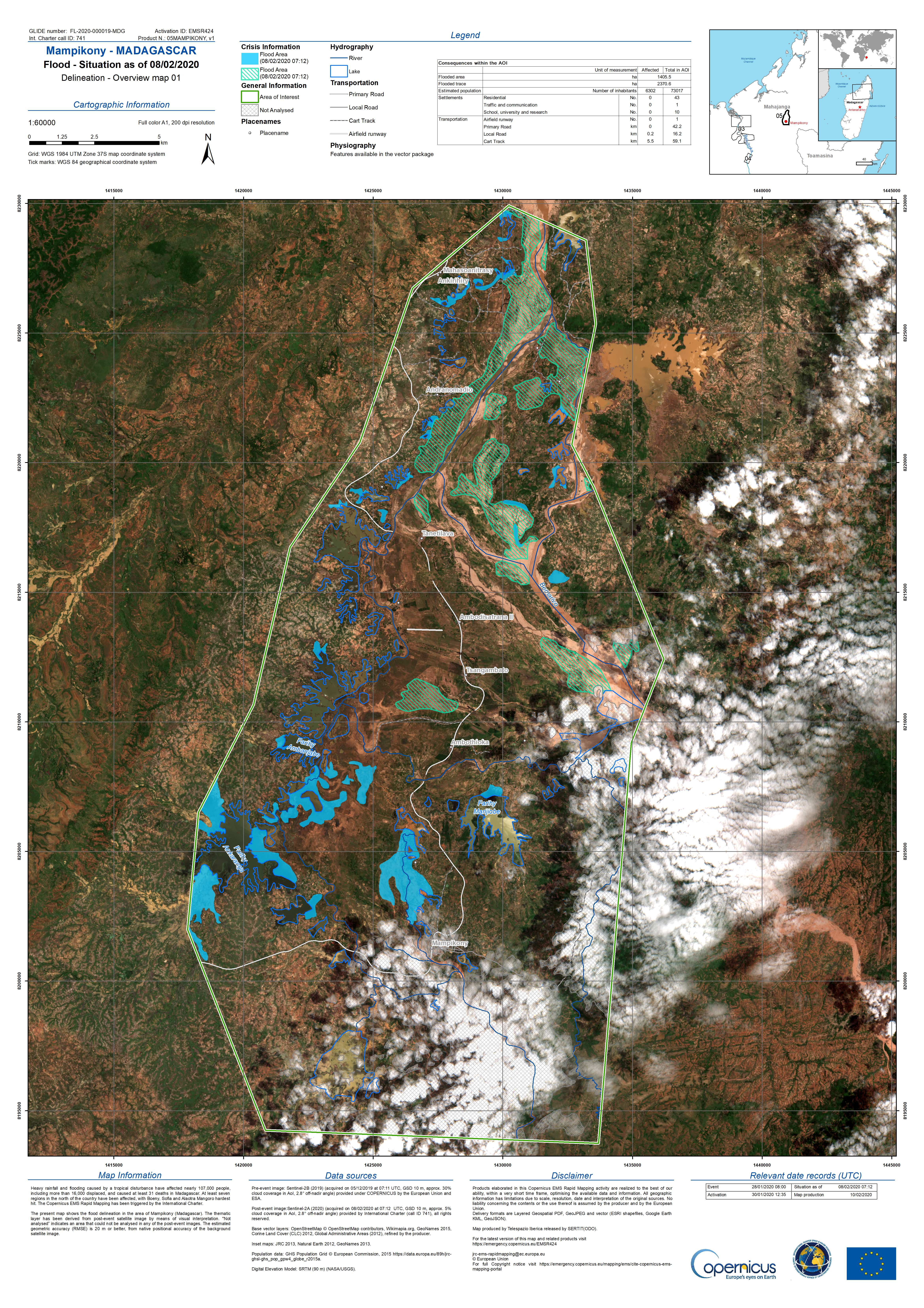
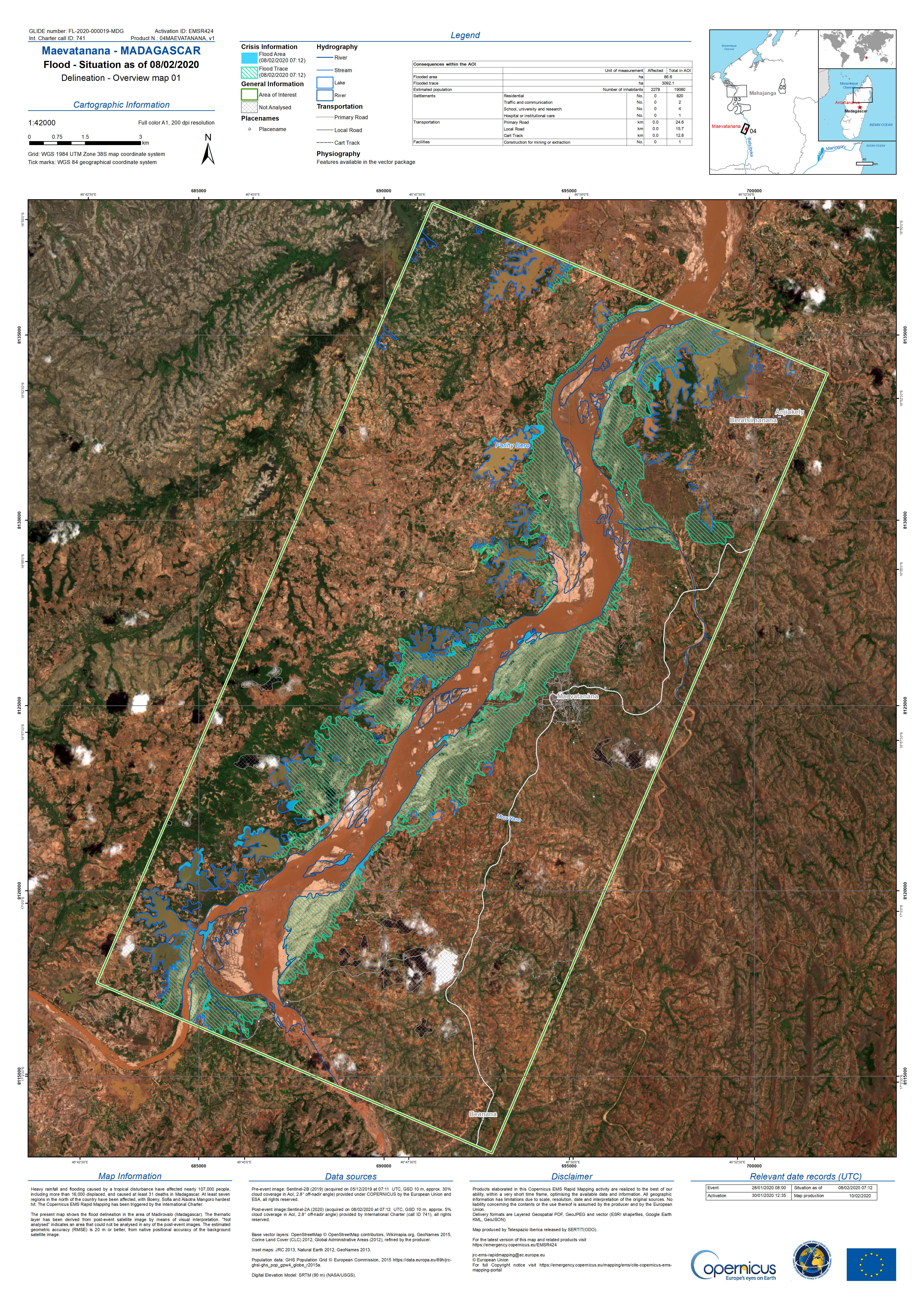
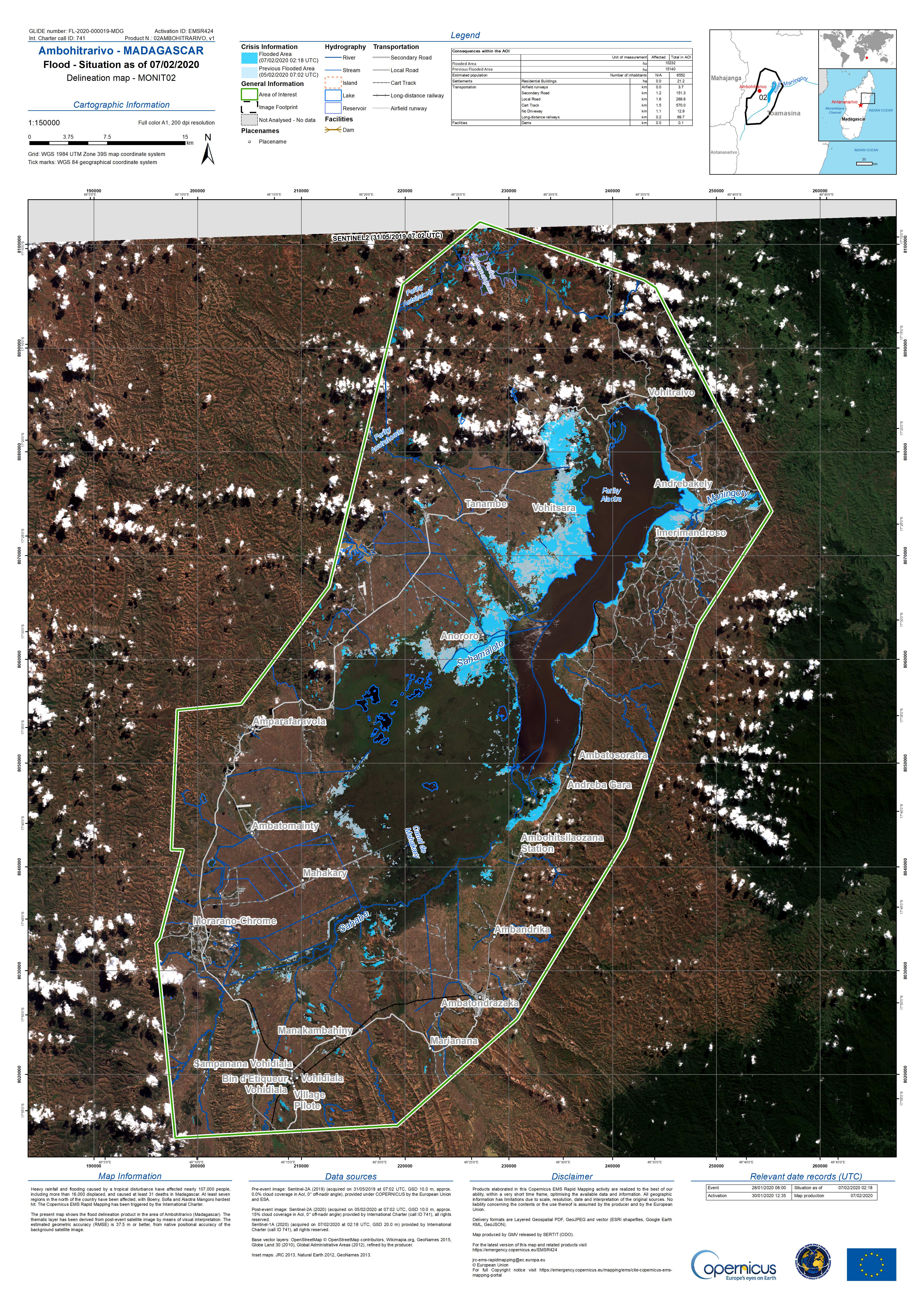
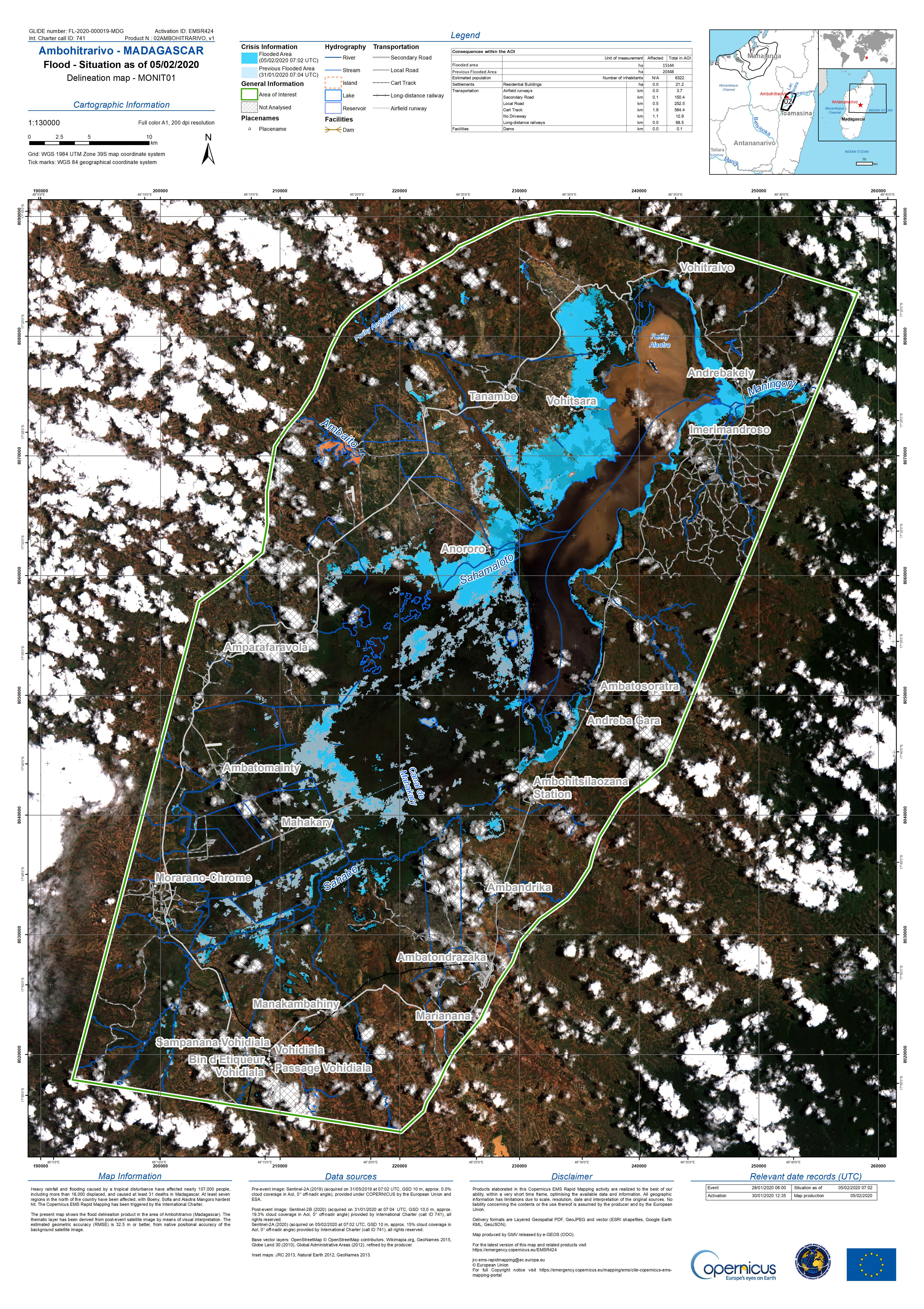
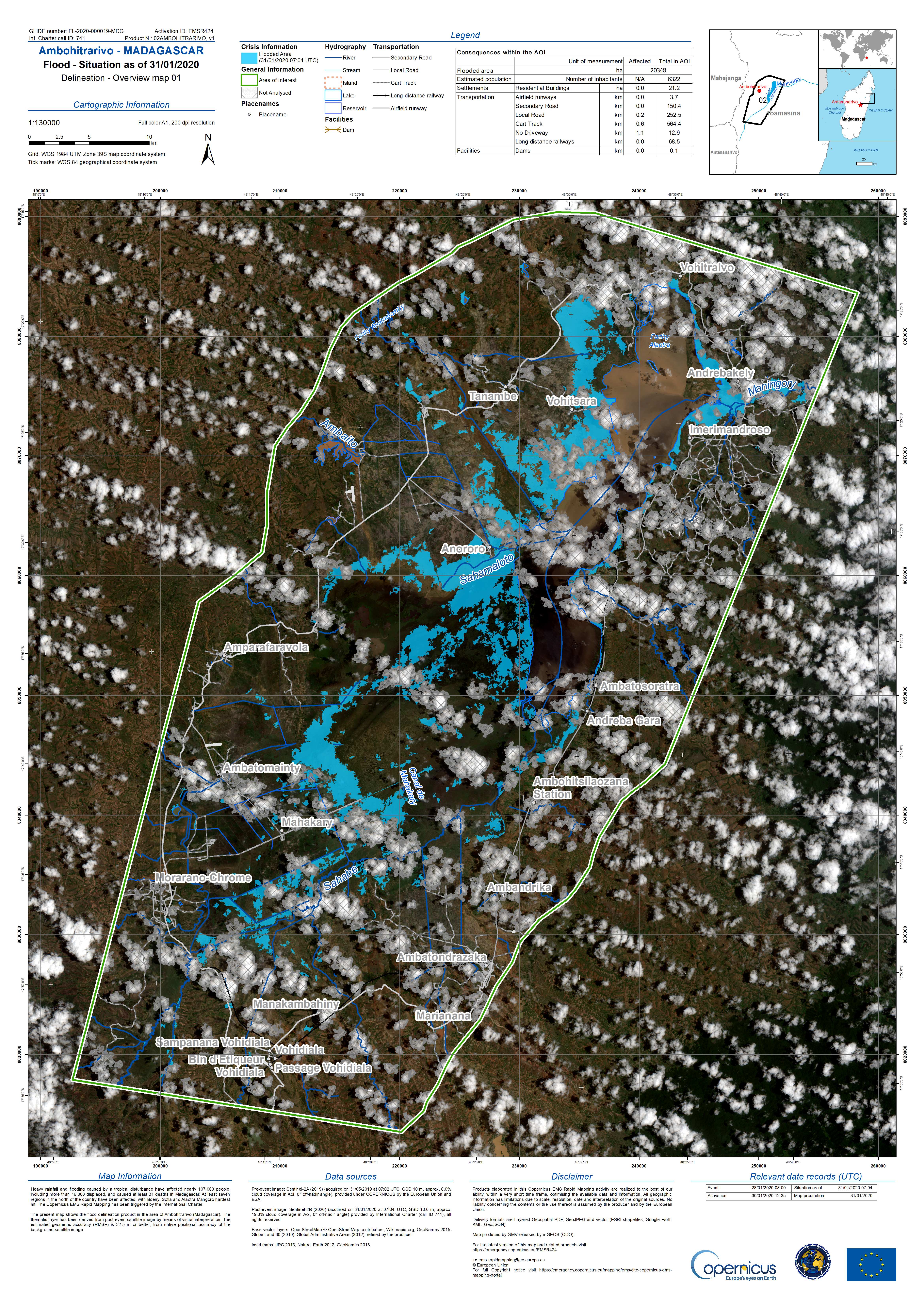
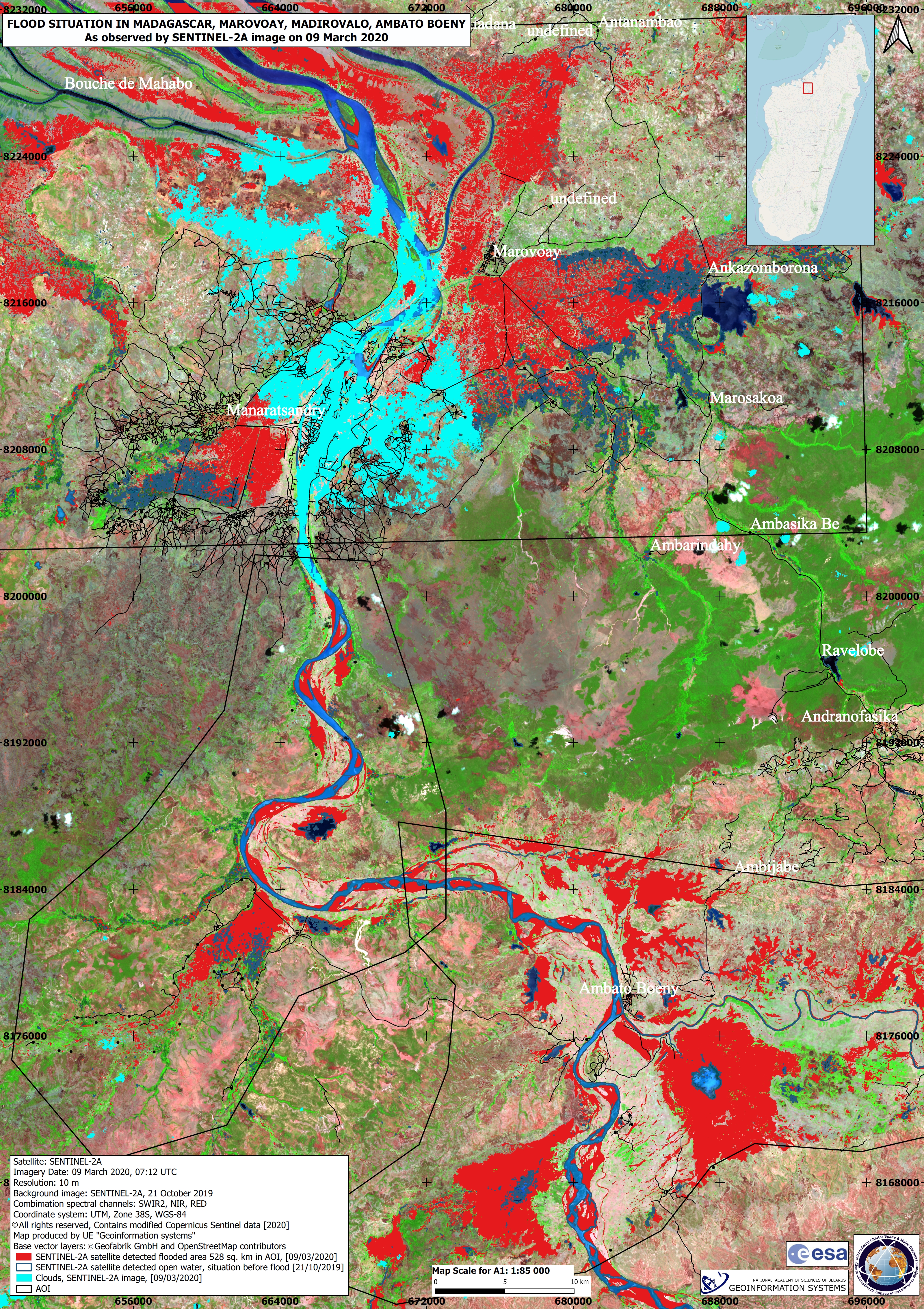
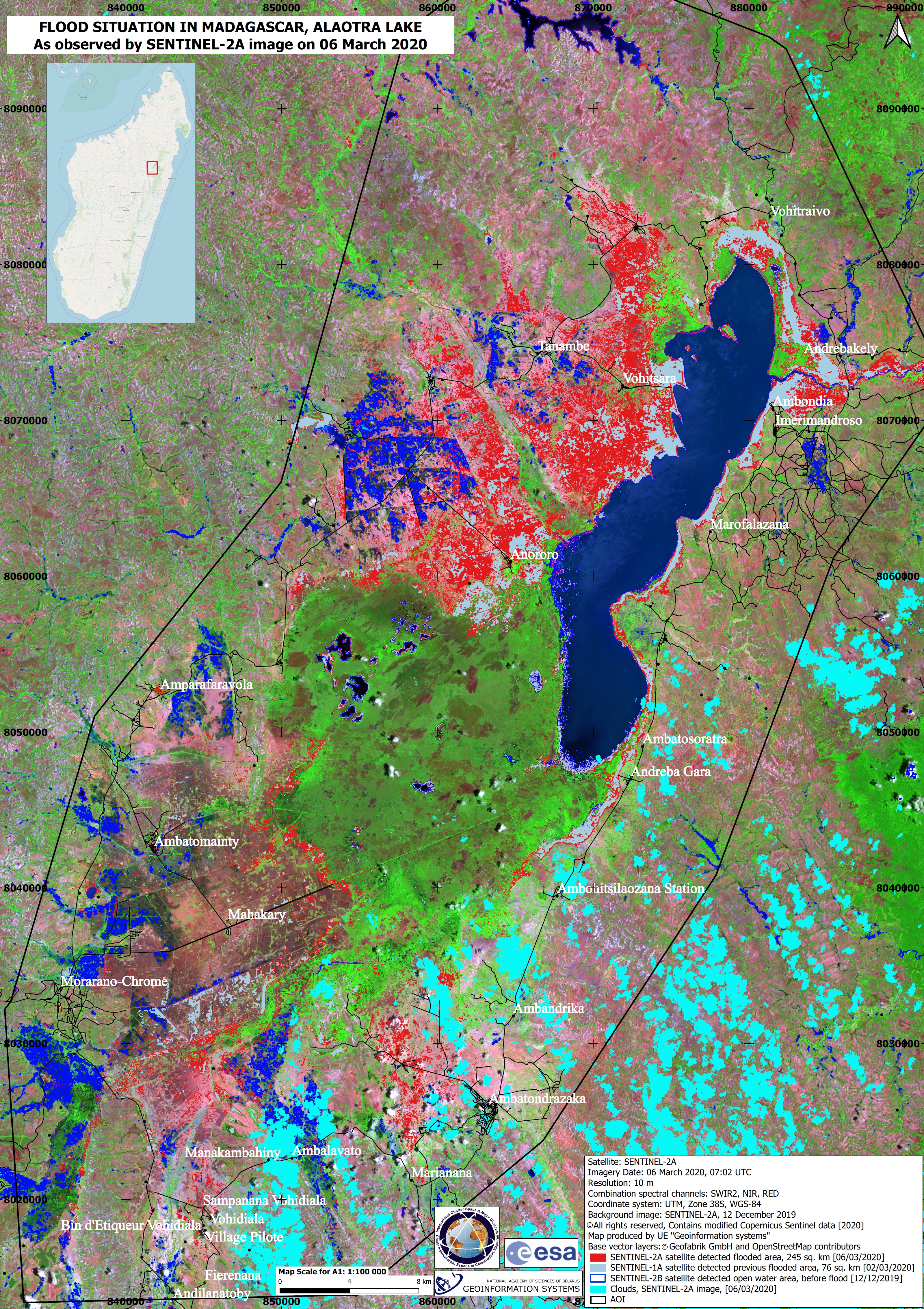
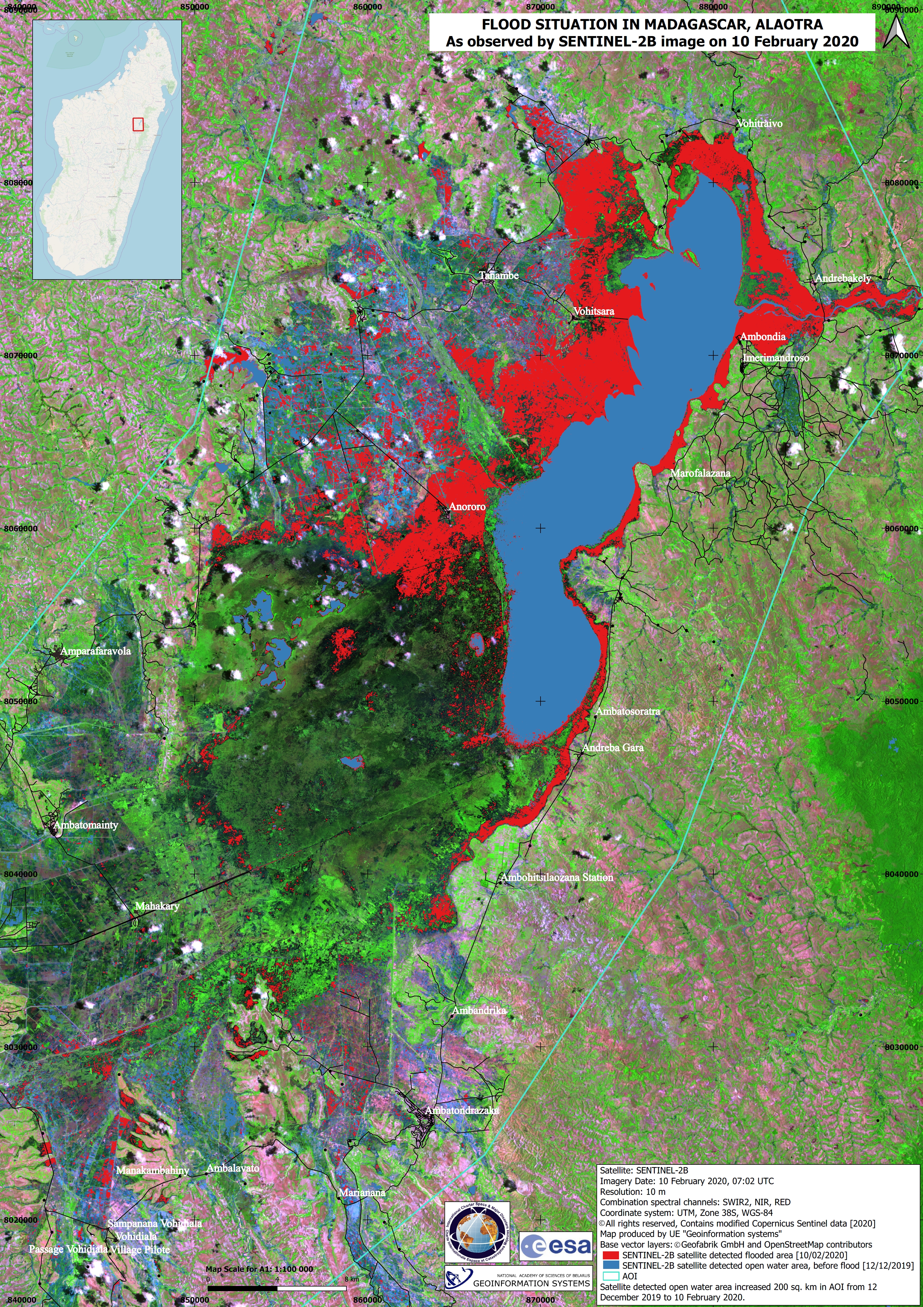
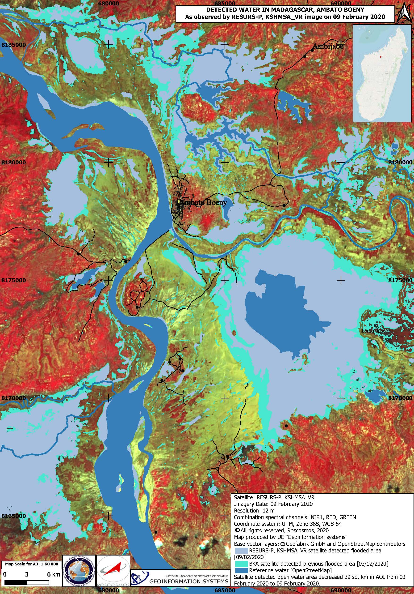
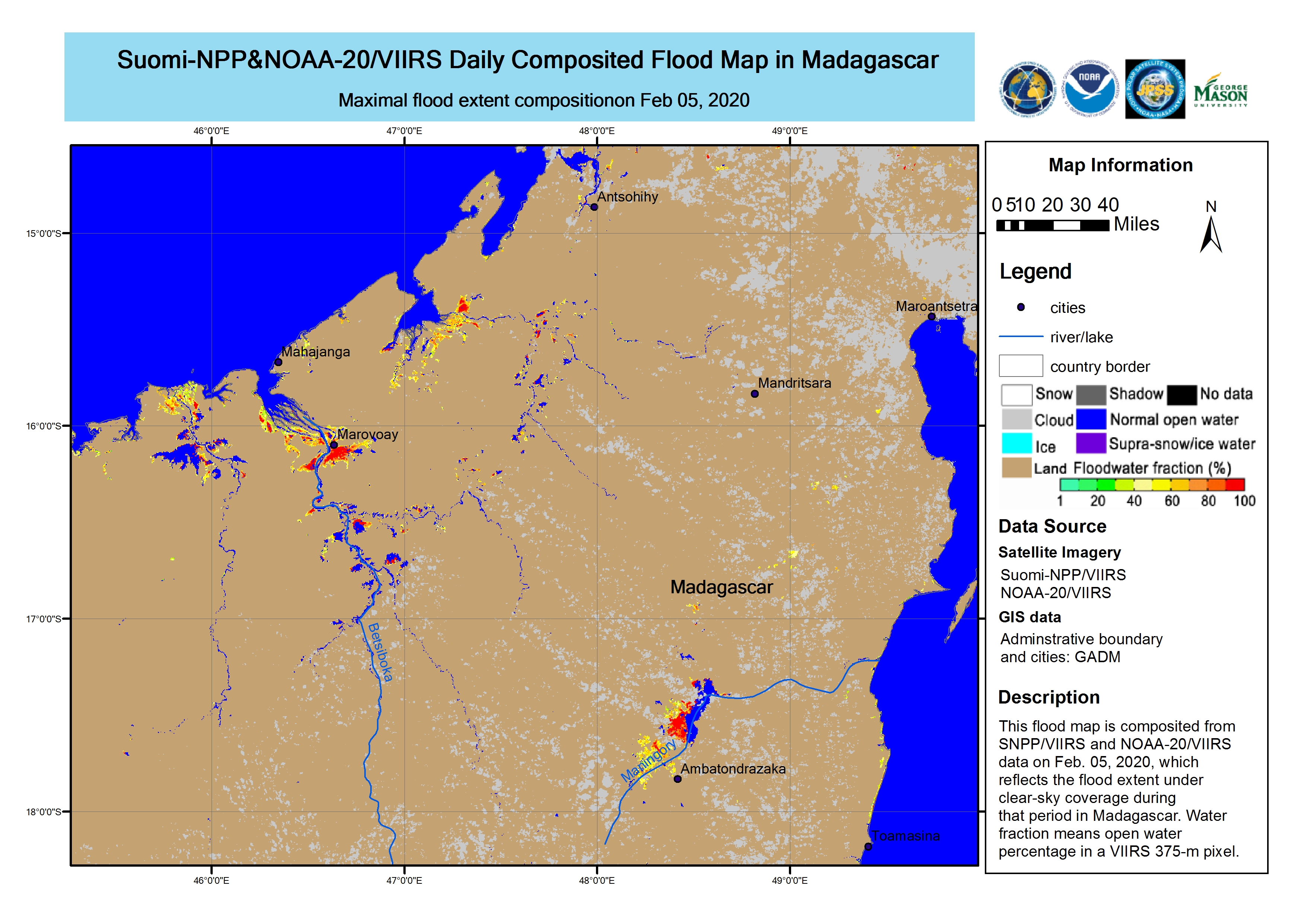
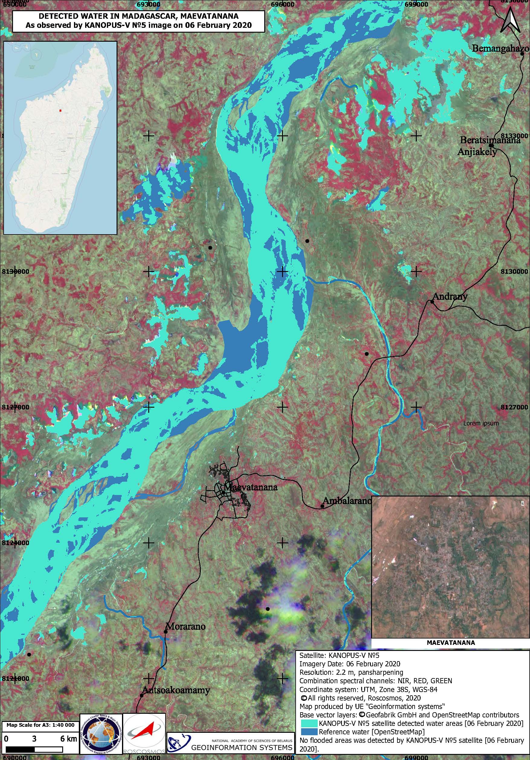
Flood and Landslide in Madagascar

Heavy rainfall throughout January has triggered flash flooding and landslides across several areas of Madagascar. At least 12 people have been killed with 18 more reported missing.

Madagascar's disaster agency BNGRC, reported the capital city Antananarivo suffered severe damage from flooding where 500 people were affected and 40 houses were destroyed. The University of Antananarivo was also badly affected and had to be closed.

Four fatalities were reported due to flash floods and landslides across Antananarivo. Two more people were killed after being washed away by floodwaters in Andapa, northern Sava Region.

Heavy flooding was also reported in the port city of Mahajanga in the Boeny region, where over a thousand people are affected with many being evacuated and placed in temporary accommodation.

The Sambirano River in the Diana region had a rapid increase in water levels and began to burst its banks. Red warnings for heavy rain were issued for areas in north-western Madagascar, while red warnings for strong winds and high waves were in place for the country's coastal western area.

The Government declared a State of Emergency on 24 January and is leading the humanitarian response. Severe weather conditions including further rainfall are forecast for the coming days.


Related News and Resources

事件类型:Flood
事件地点:Madagascar
启动宪章的日期:2020-01-27
宪章启动时间:12:19
宪章启动时区:UTC+01:00
宪章要求者:Bureau National de Gestion des Risques et des Catastrophes (BNGRC) Général de Brigade ELACK Olivier Andriakaja
启动ID:643
项目经理:SERTIT

Products

Flood delineation map over Mampikony, Madagascar

版权: Contains modified Copernicus Sentinel data (2020)
Map produced by Copernicus EMS

Information about the Product

已获得: 08/02/2020

源: Sentinel-2

Flood delineation map over Maevatanana, Madagascar

版权: Contains modified Copernicus Sentinel data (2020)
Map produced by Copernicus EMS

Information about the Product

已获得: 08/06/2020

源: Sentinel-2

Flood delineation map over Ambohitrarivo, Madagascar

版权: Contains modified Copernicus Sentinel data (2020)
Map produced by Copernicus EMS

Information about the Product

已获得: 07/02/2020

源: Sentinel-1

Flood delineation map over Ambohitrarivo, Madagascar

版权: Contains modified Copernicus Sentinel data (2020)
Map produced by Copernicus EMS

Information about the Product

已获得: 05/02/2020

源: Sentinel-2

Flood delineation map over Ambohitrarivo, Madagascar

版权: Contains modified Copernicus Sentinel data (2020)
Map produced by Copernicus EMS

Information about the Product

已获得: 31/01/2020

源: Sentinel-2

Flooding in Marovoay, Madirovalo, Ambato Boeny, Madagascar

版权: © Contains modified Copernicus Sentinel data (2020)
Map produced by National Academy of Sciences of Belarus

Information about the Product

已获得: 21/10/2019, 09/03/2020

源: Sentinel-2

Floods at Lake Alaotra, Madagascar

版权: Sentinel-1 and 2 © Contains modified Copernicus Sentinel data (2020)
Map produced by National Academy of Sciences of Belarus

Information about the Product

已获得: Sentinel-1: 02/03/2020
Sentinel-2: 12/12/2019 and 06/03/2020

源: Sentinel-1 / Sentinel-2

Flooding in Marovoay, Madirovalo, Ambato Boeny, Madagascar

版权: © Contains modified Copernicus Sentinel data (2020)
Map produced by National Academy of Sciences of Belarus

Information about the Product

已获得: 21/10/2019, 28/02/2020 and 04/03/2020

源: Sentinel-2

Flood at Mampikony, Madagascar

版权: Sentinels © Contains modified Copernicus Sentinel data (2020)
Map produced by National Academy of Sciences of Belarus

Information about the Product

已获得: Sentinel-1: 19/02/2020 and 02/03/2020
Sentinel-2: 21/10/2019

源: Sentinel-1 / Sentinel-2

Floods at Lake Alaotra, Madagascar

版权: Sentinel-1 and 2 © Contains modified Copernicus Sentinel data (2020)
Map produced by National Academy of Sciences of Belarus

Information about the Product

已获得: Sentinel-1: 19/02/2020 and 02/03/2020
Sentinel-2: 12/12/2019

源: Sentinel-1 / Sentinel-2

Floods at Lake Alaotra, Madagascar

版权: Sentinel-1 and 2 © Contains modified Copernicus Sentinel data (2020)
Map produced by National Academy of Sciences of Belarus

Information about the Product

已获得: Sentinel-1: 19/02/2020
Sentinel-2: 12/12/2019 and 25/02/2020

源: Sentinel-1 / Sentinel-2

Flooding in Marovoay, Madirovalo, Ambato Boeny, Madagascar

版权: © Contains modified Copernicus Sentinel data (2020)
Map produced by National Academy of Sciences of Belarus

Information about the Product

已获得: 21/10/2019 and 28/02/2020

源: Sentinel-2

Flood at Mampikony, Madagascar

版权: © Contains modified Copernicus Sentinel data (2020)
Map produced by National Academy of Sciences of Belarus

Information about the Product

已获得: 21/10/2019 and 28/02/2020

源: Sentinel-2

Flood at Mampikony, Madagascar

版权: Landsat 8 data and products © USGS (2020) - All rights reserved
Sentinel-1 © Contains modified Copernicus Sentinel data (2019)
Map produced by National Academy of Sciences of Belarus

Information about the Product

已获得: Landsat 8: 21/02/2020
Sentinel-1: 21/10/2019

源: Landsat 8 / Sentinel-1

Floods at Lake Alaotra, Madagascar

版权: © Contains modified Copernicus Sentinel data (2020)
Map produced by NOAA

Information about the Product

已获得: 19/02/2020

源: Sentinel-1

Flooding at Mampikony, Madagascar

版权: Sentinels © Contains modified Copernicus Sentinel data (2020)
Map produced by National Academy of Sciences of Belarus

Information about the Product

已获得: Sentinel-1: 19/02/2020
Sentinel-2: 21/10/2019

源: Sentinel-1 / Sentinel-2

Flooding at Alaotra, Madagascar

版权: Sentinel-1 and -2 © Contains modified Copernicus Sentinel data (2020)
Map produced by National Academy of Sciences of Belarus

Information about the Product

已获得: Sentinel-1: 19/02/2020
Sentinel-2: 10/02/2020

源: Sentinel-1 / Sentinel-2

Flooding at Marovay, Madirovalo and Ambato Boeny, Madagascar

版权: © Contains modified Copernicus Sentinel data (2020)
Map produced by National Academy of Sciences of Belarus

Information about the Product

已获得: Pre-disaster: 29/10/2019
Post-disaster: 18/02/2020

源: Sentinel-2

Flood in Marovoay, Madirovalo, and Ambato Boeny in Madagascar

版权: © Contains modified Copernicus Sentinel data (2020)
Map produced by National Academy of Sciences of Belarus

Information about the Product

已获得: Sentinel-1: 12/02/2020
Sentinel-2: 21/10/2019

源: Sentinel-1 / Sentinel-2

Flooding at Mampikony, Madagascar

版权: Sentinels © Contains modified Copernicus Sentinel data (2020)
Map produced by National Academy of Sciences of Belarus

Information about the Product

已获得: Sentinel-1: 12/02/2020
Sentinel-2: 21/10/2019

源: Sentinel-1 / Sentinel-2

Flooding at Maevatanana, Madagascar

版权: © DigitalGlobe Inc.
Map produced by National Academy of Sciences of Belarus

Information about the Product

已获得: 09/02/2020

源: WorldView-3

Flooding at Mampikony, Madagascar

版权: © Contains modified Copernicus Sentinel data (2020)
Map produced by National Academy of Sciences of Belarus

Information about the Product

已获得: 10/02/2020

源: Sentinel-2

Flooding at Alaotra, Madagascar

版权: © Contains modified Copernicus Sentinel data (2020)
Map produced by National Academy of Sciences of Belarus

Information about the Product

已获得: 10/02/2020

源: Sentinel-2

Water detected in Madagascar, Ambato Boeny

版权: © All rights reserved, Roscosmos, 2020
Map produced by UE "Geoinformation Systems"

Information about the Product

已获得: 09/02/2020

源: Resurs-P / KSHMSA_VR

Composited flood water extents in Madagascar

版权: © NOAA (2020)
Map produced by George Mason University

Information about the Product

已获得: 05/02/2020

源: Suomi NPP

Detected water in Maevatanana, Madagascar

版权: © All rights reserved, Roscosmos, 2020
Map produced by UE "Geoinformation Systems"

Information about the Product

已获得: 06/02/2020

源: KANOPUS-V

Flood assessment, Mampikony, Madagascar

版权: Landsat 8 data and products © USGS (2020) - All rights reserved
Sentinel-2 © Contains modified Copernicus Sentinel data (2020)
Map produced by National Academy of Sciences of Belarus

Information about the Product

已获得: Sentinel-2: 03/02/2020
Landsat 8: 05/02/2020

源: Sentinel-2 / Landsat 8

Floods in Madagascar, MahaJamba - Mampikony

版权: © Contains modified Copernicus Sentinel data (2020)
Map produced by National Academy of Sciences of Belarus, Geoinformation Systems

Information about the Product

已获得: 03/02/2020

源: Sentinel-2

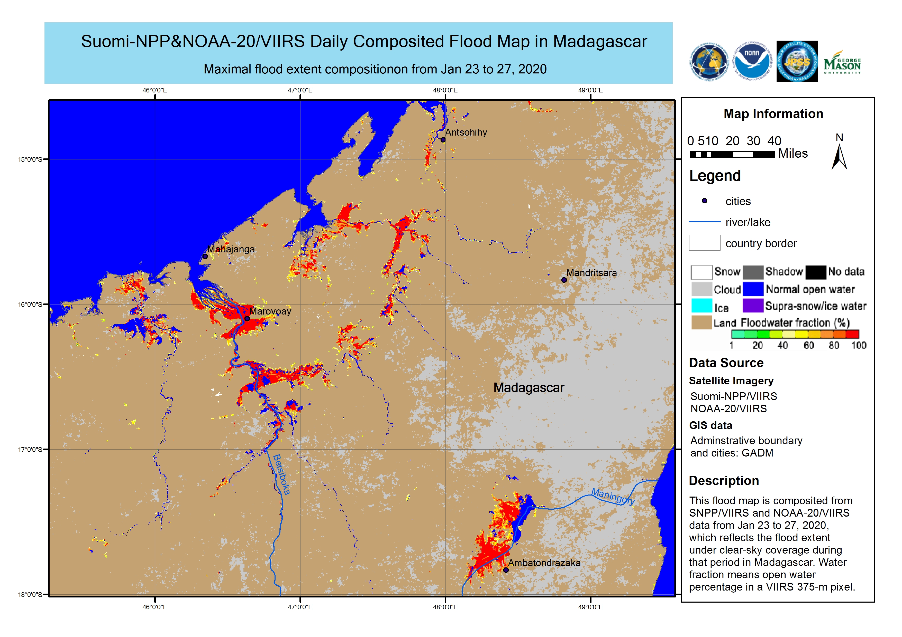
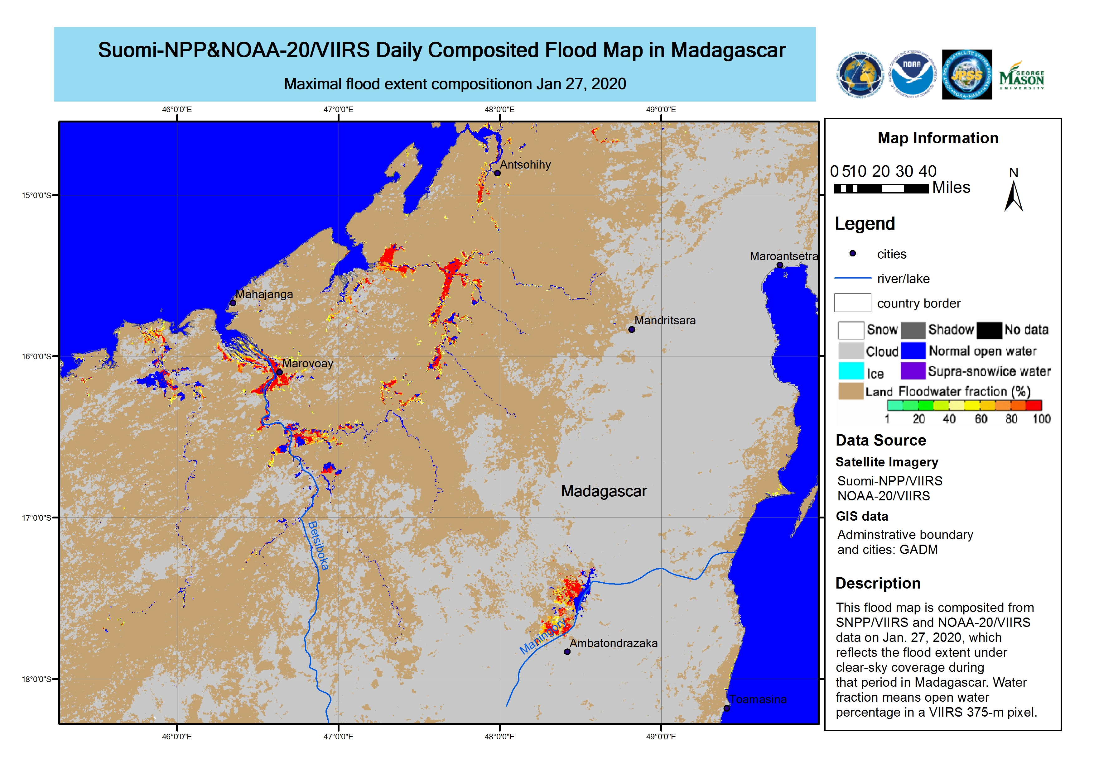
Satellite detected waters extents, Republic of Madagascar

版权: © NOAA (2020)
Map produced by UNITAR/UNOSAT

Information about the Product

已获得: 29/01/2020 to 02/02/2020

源: Suomi NPP

Floods in Madagascar

版权: © Contains modified Copernicus Sentinel data (2020)
Produced by NOAA

Information about the Product

已获得: 01/02/2020

源: Sentinel-1

Satellite Detected Water in Ambatoboney, Morafeno, Maevatanana Madagascar

版权: Contains modified Belarusian satellite data
© UE "Geoinformation systems
Map produced by UE "Geoinformation systems"

Information about the Product

已获得: 03/02/2020

源: BKA

Floods in Madagascar

版权: © Contains modified Copernicus Sentinel data (2020)
Produced by NOAA

Information about the Product

已获得: 31/01/2020

源: Sentinel-1

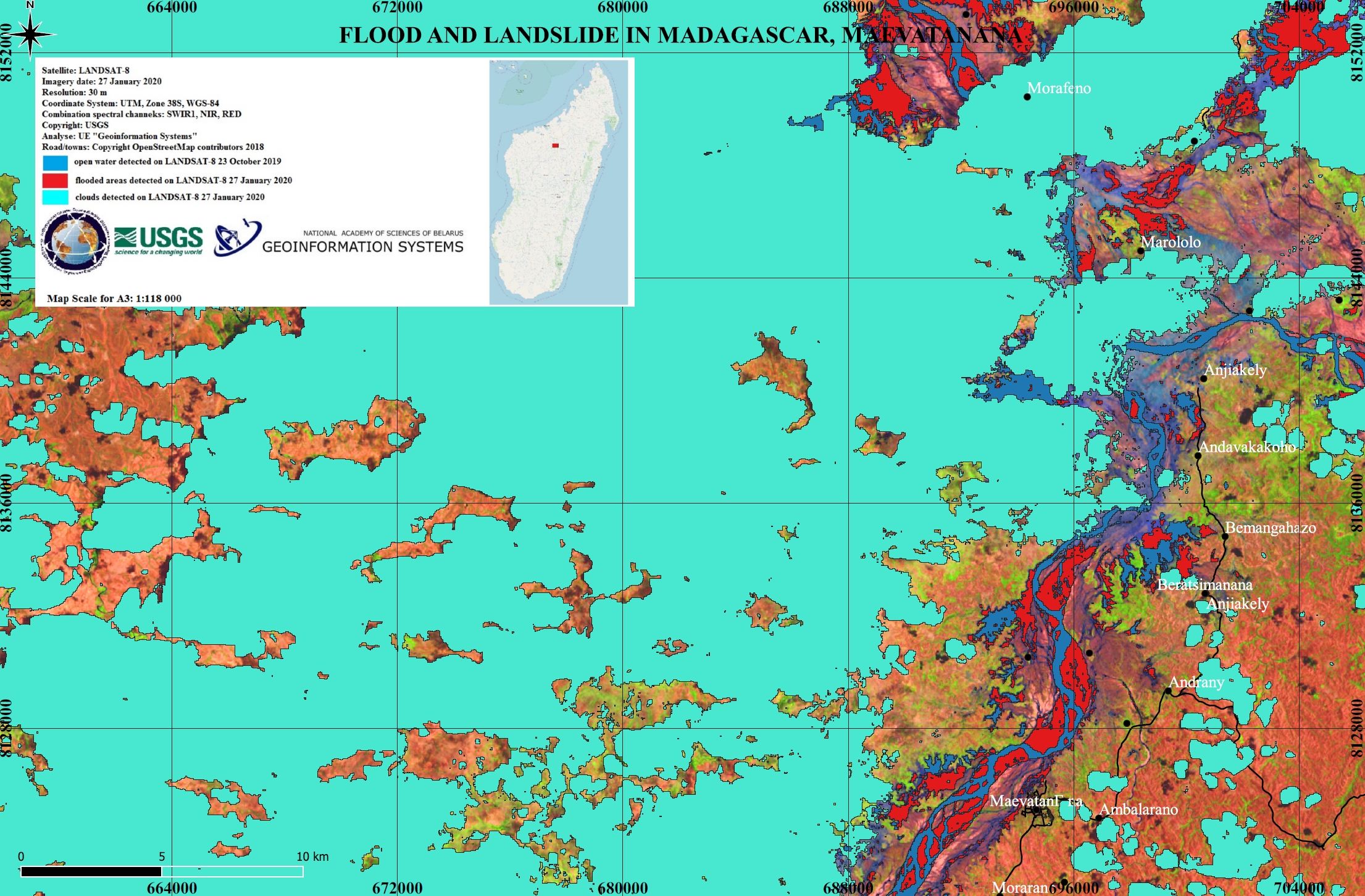
Flood in Morafeno, Madagascar

版权: TerraSAR-X © DLR e. V. 2020, Distribution: Airbus DS Geo GmbH
Sentinel-2 © Contains modified Copernicus Sentinel data (2019)
Map produced by National Academy of Sciences of Belarus

Information about the Product

已获得: TerraSAR-X: 29/01/2020 and 02/02/2020
Sentinel-2: 20/11/2019

源: TerraSAR-X / Sentinel-2

Flooded areas in Boriziny, Madagascar

版权: Sentinels © Contains modified Copernicus Sentinel data (2020)
Map produced by National Academy of Sciences of Belarus

Information about the Product

已获得: Sentinel-1: 19/01/2020 and 31/01/2020
Sentinel-2: 21/10/2019

源: Sentinel-1 / Sentinel-2

Flooded areas in Amparafaravola, Madagascar

版权: Sentinels © Contains modified Copernicus Sentinel data (2020)
Map produced by National Academy of Sciences of Belarus

Information about the Product

已获得: Sentinel-1: 14/01/2020 and 26/01/2020
Sentinel-2: 12/11/2019

源: Sentinel-1 / Sentinel-2

Flood situation in Ambohitrarivo, Madagascar

版权: Sentinel-2 © Contains modified Copernicus Sentinel data (2019)
ALOS-2 © JAXA (2020) All rights reserved
Map produced by Copernicus EMS

Information about the Product

已获得: Sentinel-2: 31/05/2019
ALOS-2: 29/01/2020

源: Sentinel-2 / ALOS-2

Flooded areas in Madagascar

版权: TerraSAR-X © DLR e. V. 2020, Distribution: Airbus DS Geo GmbH
Sentinel-2 © Contains modified Copernicus Sentinel data (2019)
Map produced by National Academy of Sciences of Belarus

Information about the Product

已获得: TerraSAR-X: 04/04/2008 and 29/01/2020
Sentinel-2: 20/11/2019

源: TerraSAR-X / Sentinel-2

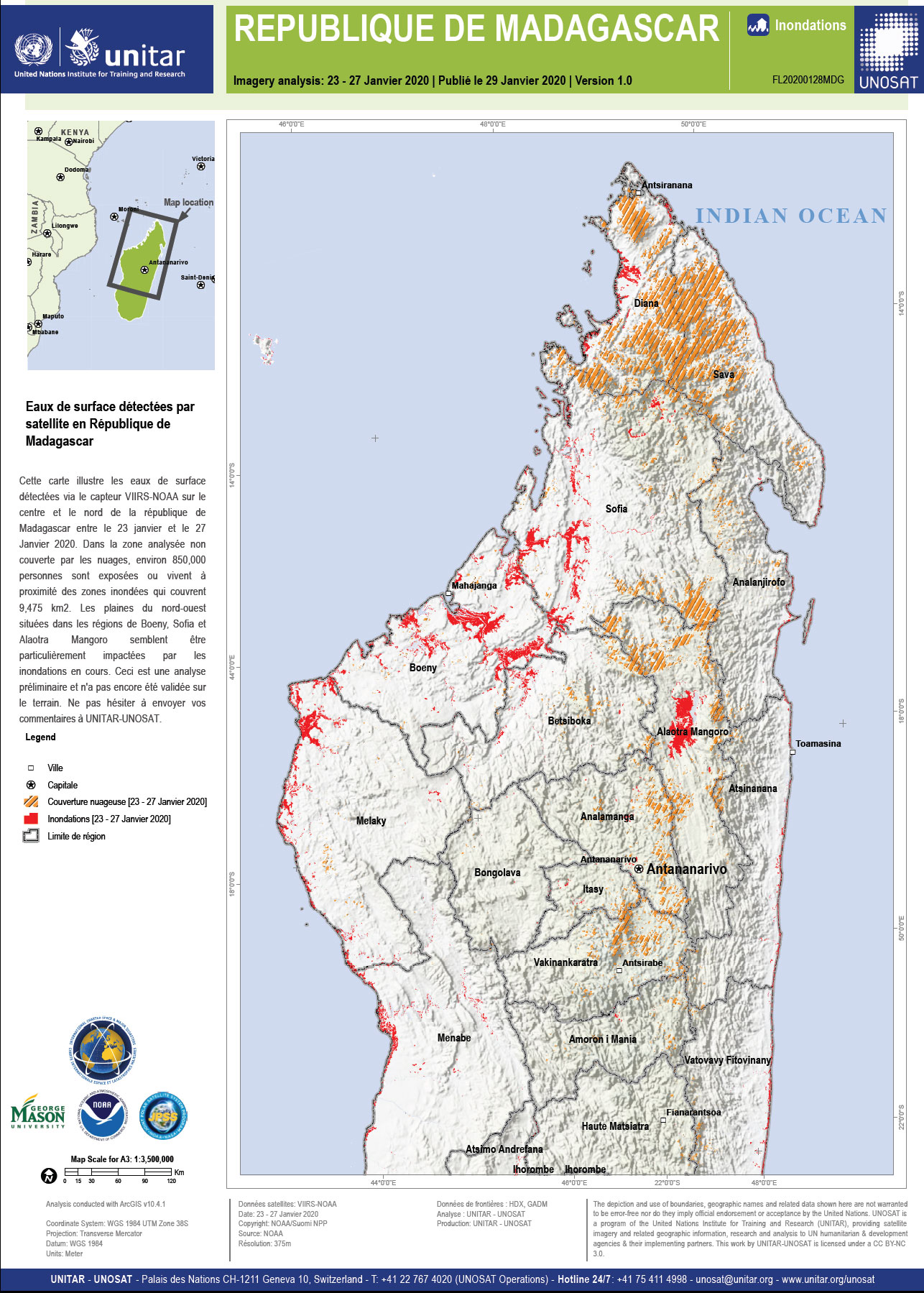
Surface water detected in Madagascar

版权: © NOAA (2020)
Map produced by UNITAR/UNOSAT

Information about the Product

已获得: 23/01/2020 to 27/01/2020

源: Suomi NPP

Flood and landslide analysis in Madagascar

版权: Landsat 8 data and products © USGS (2020) - All rights reserved
Map produced by National Academy of Sciences of Belarus

Information about the Product

已获得: 23/01/2020 and 27/01/2020

源: Landsat 8

Composited flood water extents in Madagascar

版权: © NOAA (2020)
Map produced by George Mason University

Information about the Product

已获得: 23 to 27/01/2020

源: Suomi NPP

Composited flood water extents in Madagascar

版权: © NOAA (2020)
Map produced by George Mason University

Information about the Product

已获得: 27/01/2020

源: Suomi NPP

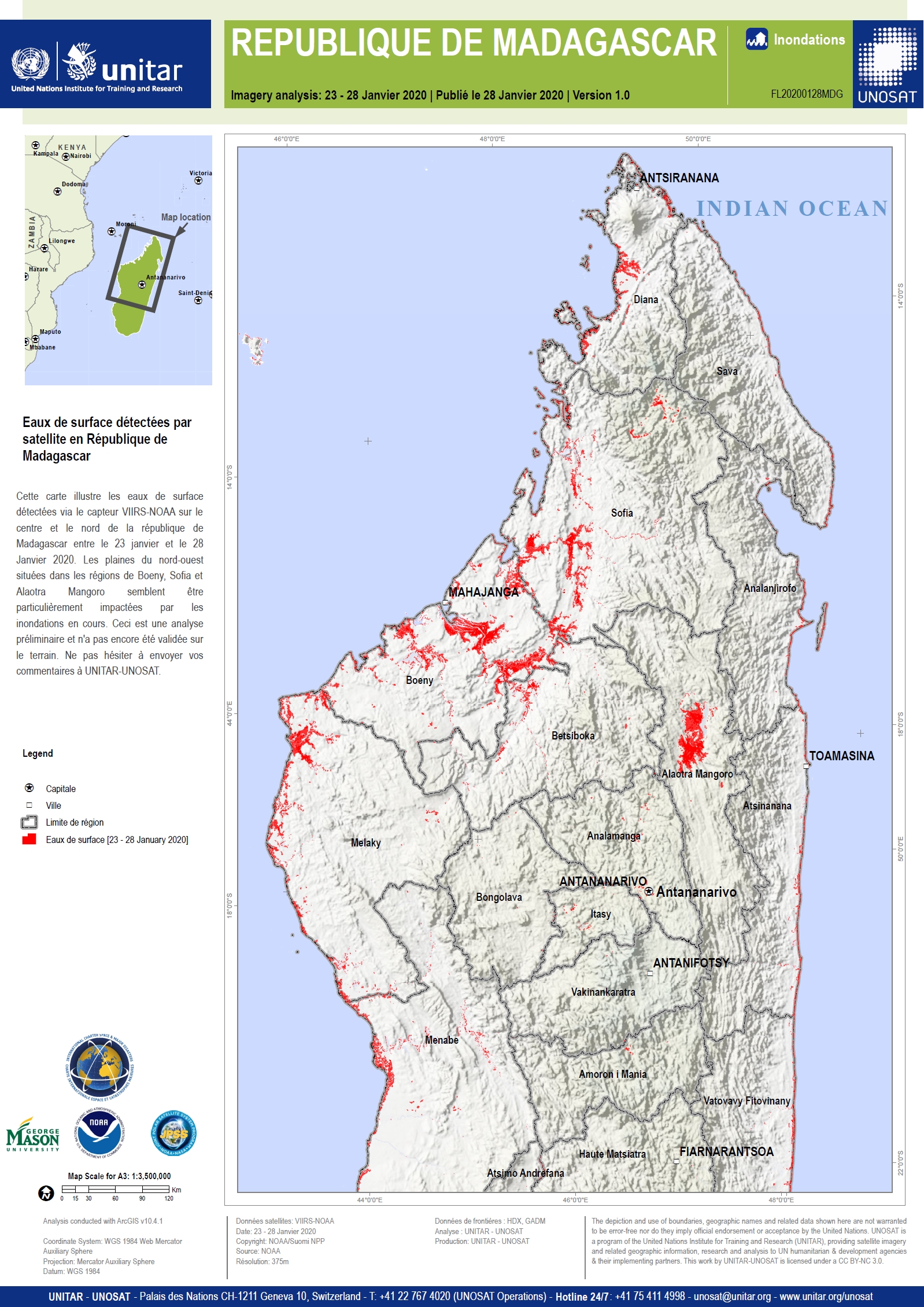
Satellite detected waters in Madagascar

版权: © NOAA (2020)
Map produced by UNITAR/UNOSAT

Information about the Product

已获得: 23 to 28/01/2020

源: Suomi NPP

返回完整的响应档案