 English
 Spanish
 French
 Chinese
 Russian
 Portuguese
 最新宪章启动
Charter activations
菲律宾台风黑格比
台风黑格比(在当地叫做鲁比)于12月6日登陆菲律宾。黑格比在菲律宾东部登陆,为三级飓风,造成了21人死亡。据估计,有近一百万人受到黑格比的影响。
台风黑格比在登陆之前加强为五级飓风,是萨菲尔-辛普森等级法中的最高级别,但在登陆菲律宾前不久降为三级飓风。去年十一月,五级台风海燕给菲律宾带来了毁灭性的影响,造成了七千多人死亡,数百万人无家可归以及大量的破坏。黑格比来袭之时,菲律宾群岛仍处于此次灾难的恢复之中。
出于对台风造成威胁的恐惧,成千上万的人在黑格比到来之前就已撤离。他们躲到政府设立的紧急避难所躲避,或是在风暴来临之时搬到安全的地方。此次提前撤离,加上黑格比比预期的强度要弱,挽救了许多生命。
登陆后,黑格比缓慢向西北方向移动,在之后的两天经过菲律宾北部。风暴带来了暴雨和强风,造成菲律宾东部房屋的严重损毁,并引发了洪水。据报道,将近20,000吨水稻庄稼被风暴摧毁,致使菲律宾要从别处获取资源以保证2015年充足的粮食供应。
据分析,黑格比造成了38,000 房屋的损毁,受灾人数为四百万人。
| 事件类型: | 洪水,海洋风暴 - 台风 |
| 事件地点: | 菲律宾 |
| 启动宪章的日期: | 2014年12月4日 |
| 宪章要求者: | UNITAR/UNOSAT代表 UN OCHA Philippines |
| 项目经理: | ESA |
Products
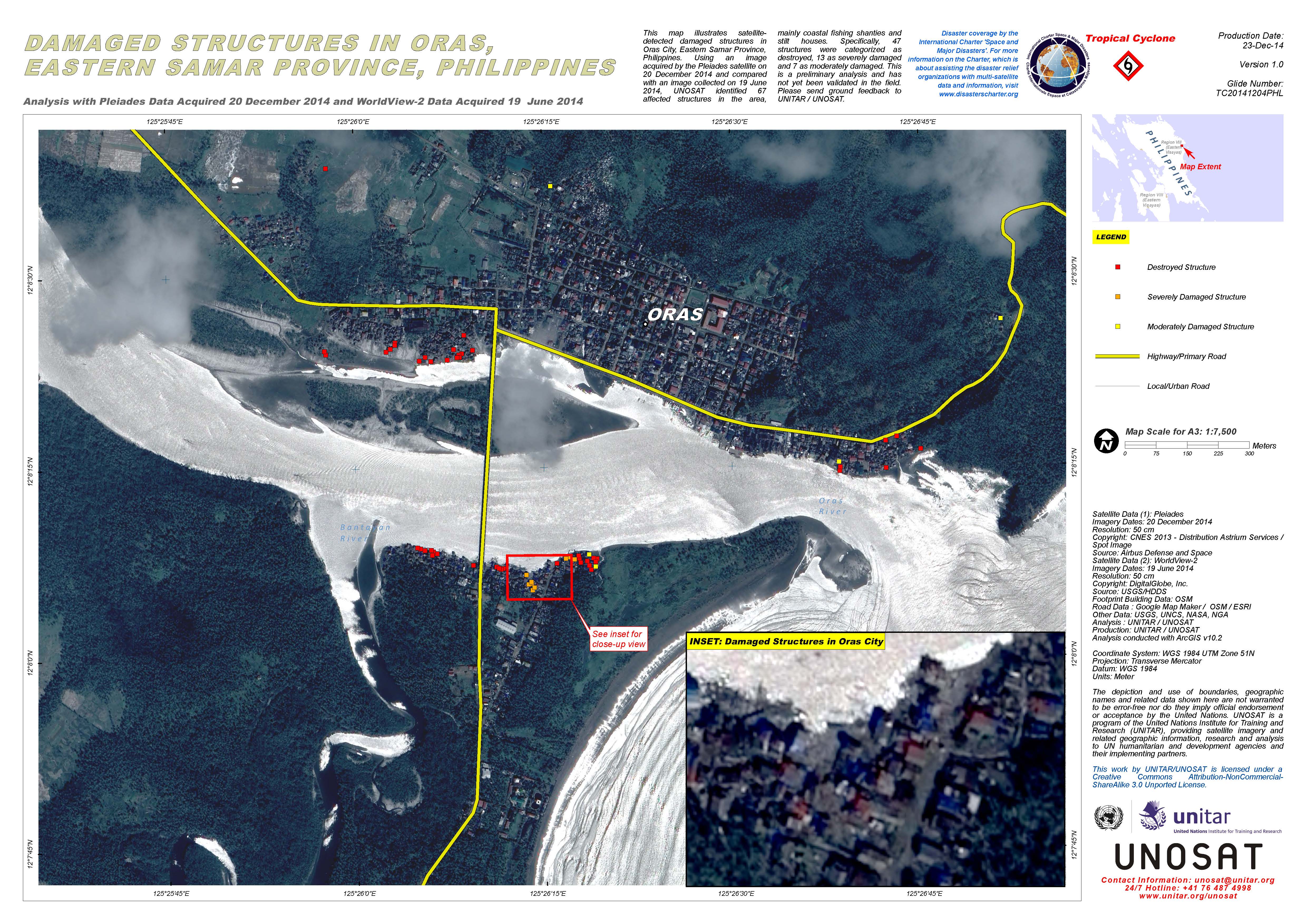
Damaged structures in Oras, Eastern Samar Province, in the Philippines
版权: Pleiades © CNES 2014 - Distribution: Airbus Defence and Space, all rights reserved
WorldView-2 © DigitalGlobe Inc.
Map produced by UNITAR/UNOSAT
Information about the Product
已获得: Pleiades: 20/12/2014
WorldView-2: 19/06/2014
源: Pleiades / WorldView-2
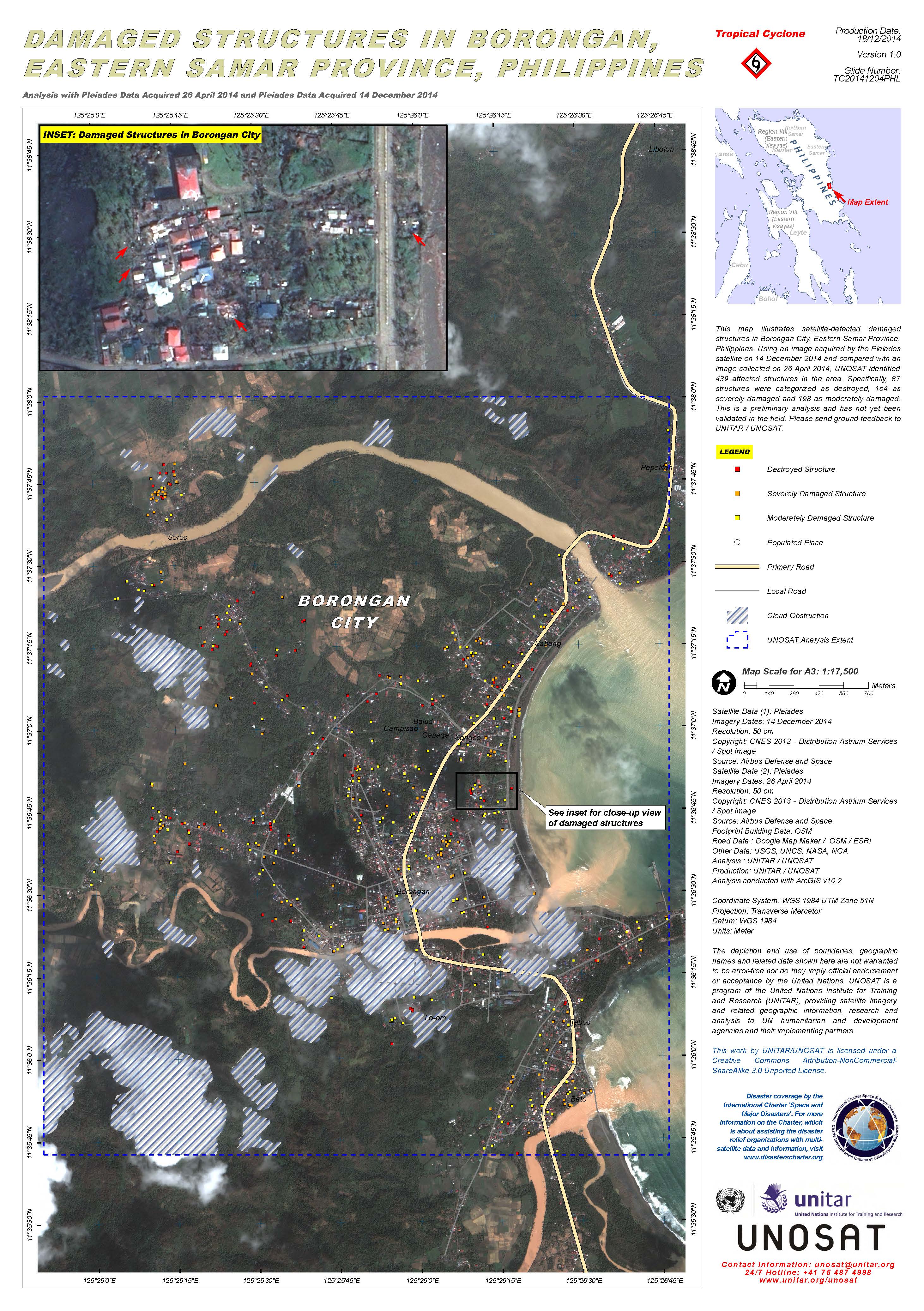
Damaged structures in Borongan, Eastern Samar Province, in the Philippines
版权: Pleiades © CNES 2014 - Distribution: Airbus Defence and Space, all rights reserved
Map produced by UNITAR/UNOSAT
Information about the Product
已获得: Pre-disaster: 26/04/2014
Post-disaster: 14/12/2014
源: Pleiades

Damaged structures in San Julian area, Eastern Samar, in the Philippines
版权: DigitalGlobe Inc.
Map produced by UNITAR/UNOSAT
Information about the Product
已获得: WorldView-2: 12/12/2014
WorldView-1: 12/07/2014
源: WorldView-2 / WorldView-1
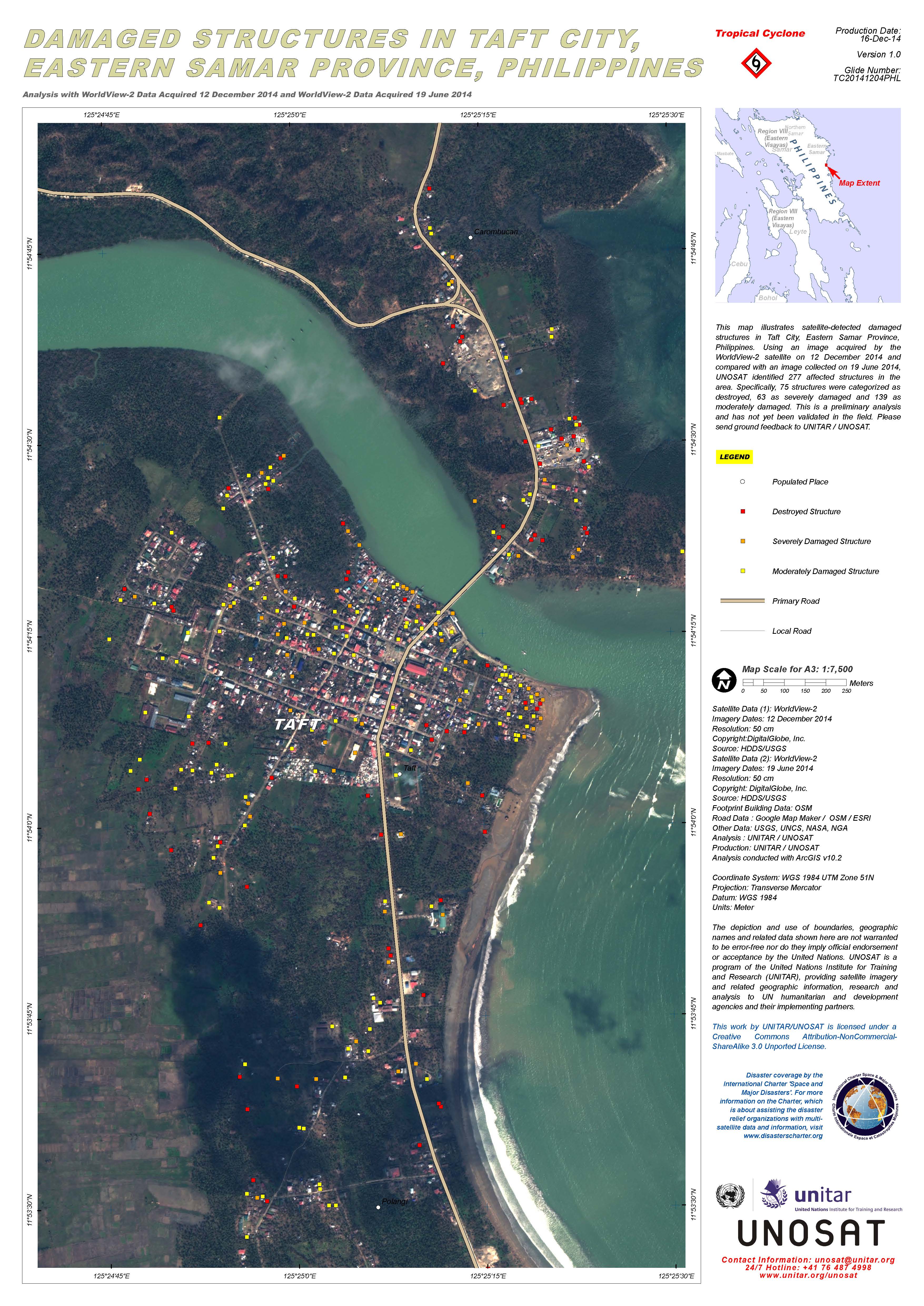
Damaged structures in Taft City, Eastern Samar Province, in the Philippines
版权: DigitalGlobe Inc.
Map produced by UNITAR/UNOSAT
Information about the Product
已获得: Pre-disaster: 19/06/2014
Post-disaster: 12/12/2014
源: WorldView-2
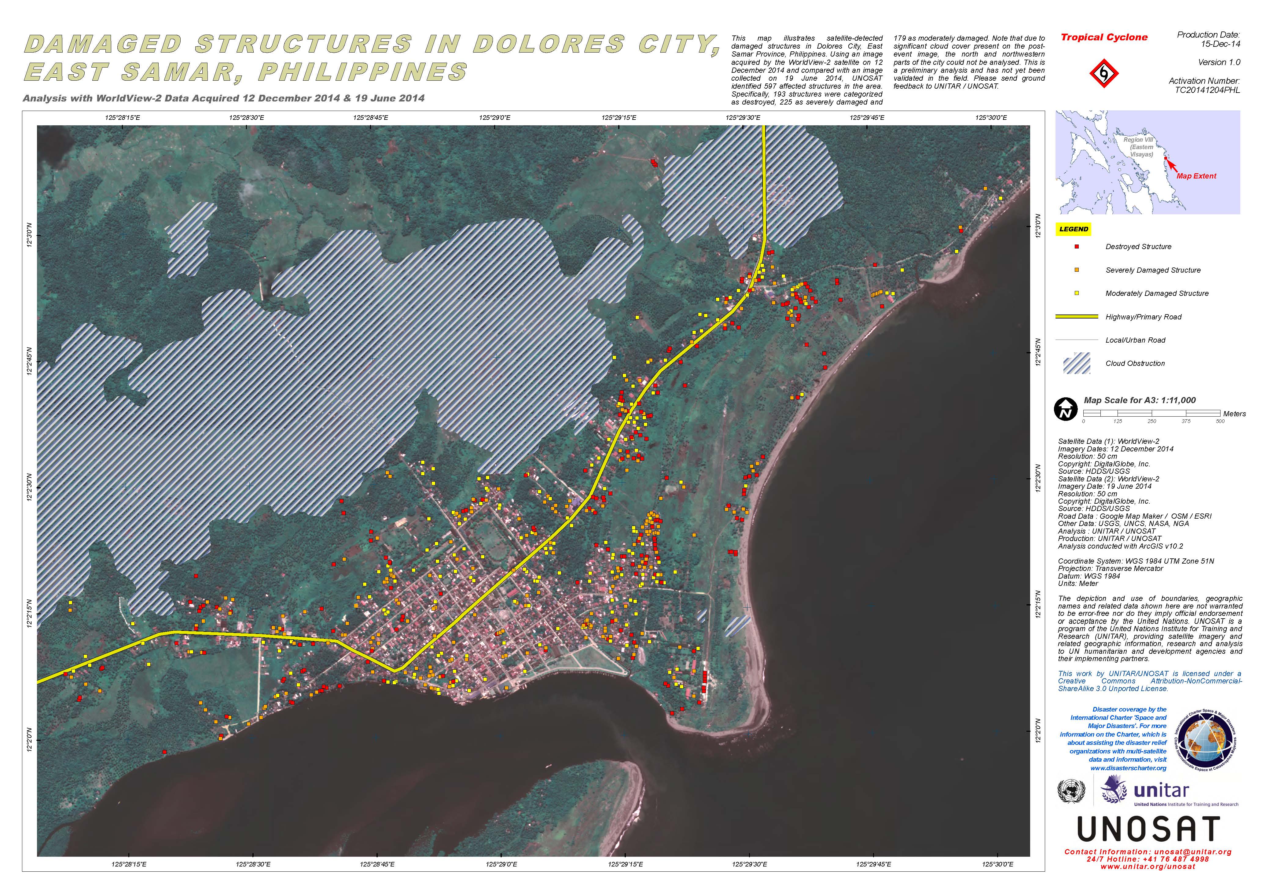
Damaged structures in Dolores City, East Samar, in the Philippines
版权: DigitalGlobe Inc.
Map produced by UNITAR/UNOSAT
Information about the Product
已获得: Pre-disaster: 19/06/2014
Post-disaster: 12/12/2014
源: WorldView-2
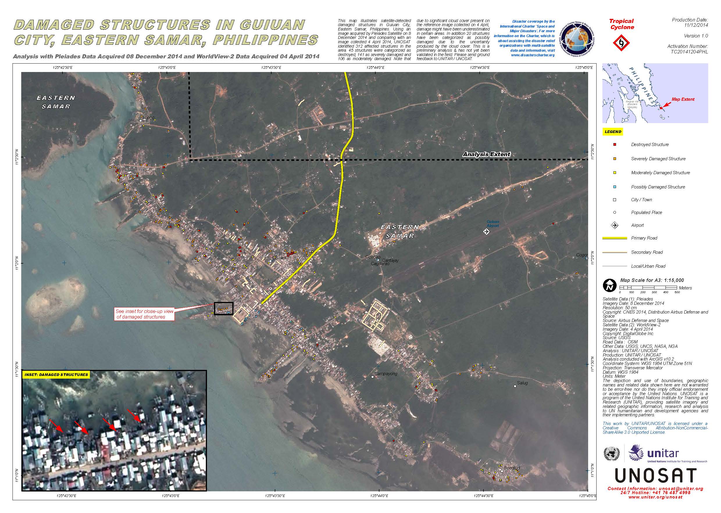
Damaged structures in Guiuan City, Eastern Samar, in the Philippines
版权: Pleiades © CNES 2014 - Distribution: Airbus Defence and Space, all rights reserved
WorldView-2 © DigitalGlobe Inc.
Map produced by UNITAR/UNOSAT
Information about the Product
已获得: Pleiades: 08/12/2014
WorldView-2: 04/04/2014
源: Pleiades / WorldView-2
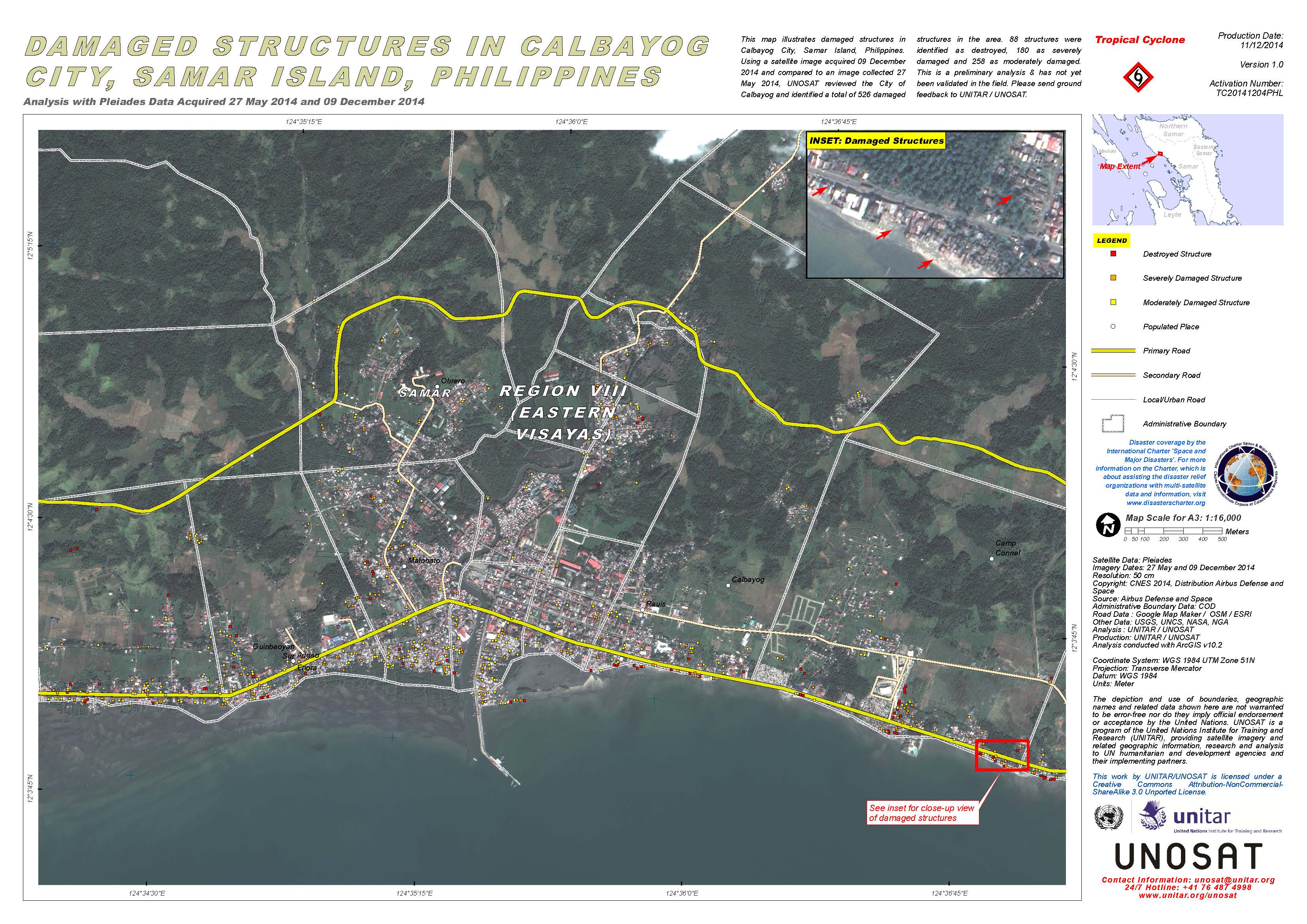
Damaged structures in Calbayog City, Samar Island, in the Philippines
版权: Pleiades © CNES 2014 - Distribution: Airbus Defence and Space, all rights reserved
Map produced by UNITAR/UNOSAT
Information about the Product
已获得: Pre-disaster: 27/05/2014
Post-disaster: 09/12/2014
源: Pleiades

Satellite detected waters over Can-Avid in the Dolores area of Eastern Samar, in the Eastern Visayas region of the Philippines
版权: Copernicus 2014 / ESA
Map produced by UNITAR/UNOSAT
Information about the Product
已获得: Pre-disaster: 12/11/2014
Post-disaster: 08/12/2014
源: Sentinel-1

Potentially damaged zones in Tacloban City, Leyte, in the Philippines after Typhoon Hagupit
版权: Pleiades © CNES 2014 - Distribution: Airbus Defence and Space, all rights reserved
WorldView-2 © DigitalGlobe Inc.
Map produced by UNITAR/UNOSAT
Information about the Product
已获得: Pleiades: 09/12/2014
WorldView-2: 17/08/2014
源: Pleiades / WorldView-2
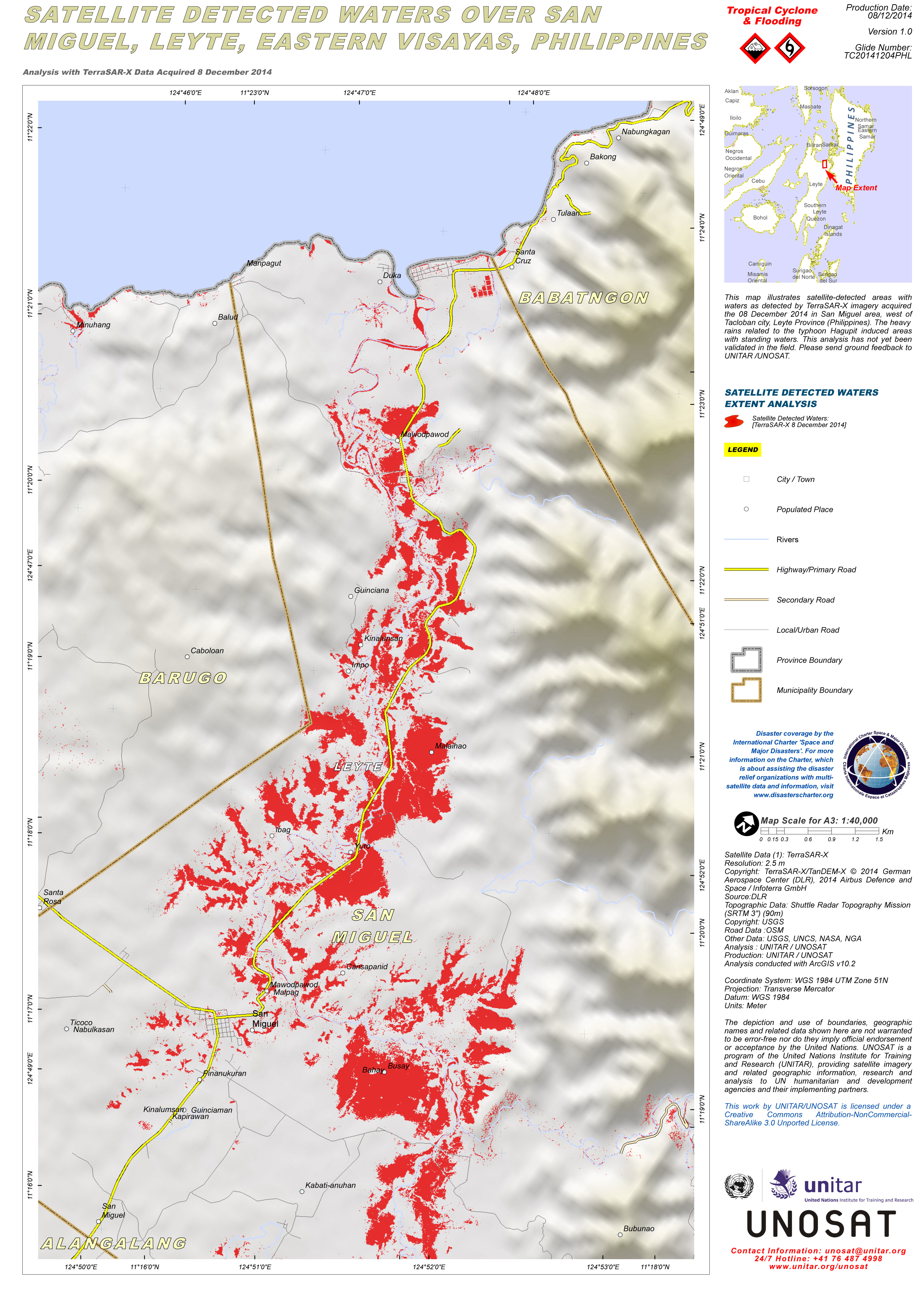
Map illustrating satellite-detected areas with waters as detected by TerraSAR-X imagery acquired over the San Miguel area, west of Tacloban city, Leyte Province in the Philippines.
版权: TerraSAR-X © German Aerospace Center (DLR), 2014 Airbus Defence and Space / Infoterra GmbH
SRTM 3 © USGS
Map produced by UNITAR/UNOSAT
Information about the Product
已获得: 08/12/2014
源: TerraSAR-X / SRTM
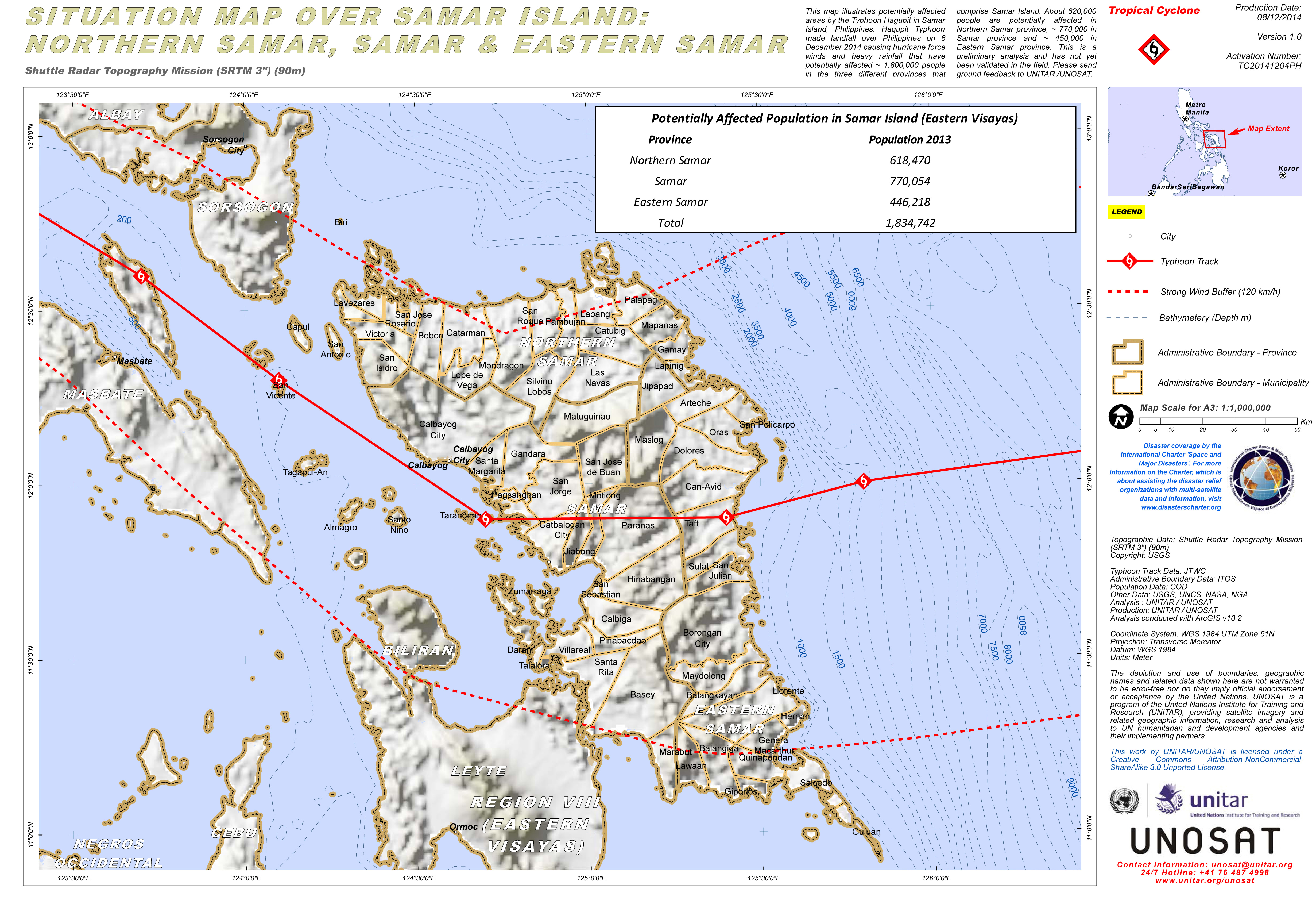
Situation map illustrating potentially affected areas of Samar Island, in the Philippines, by Typhoon Hagupit.
版权: USGS
Map produced by UNITAR/UNOSAT
Information about the Product
源: SRTM 3
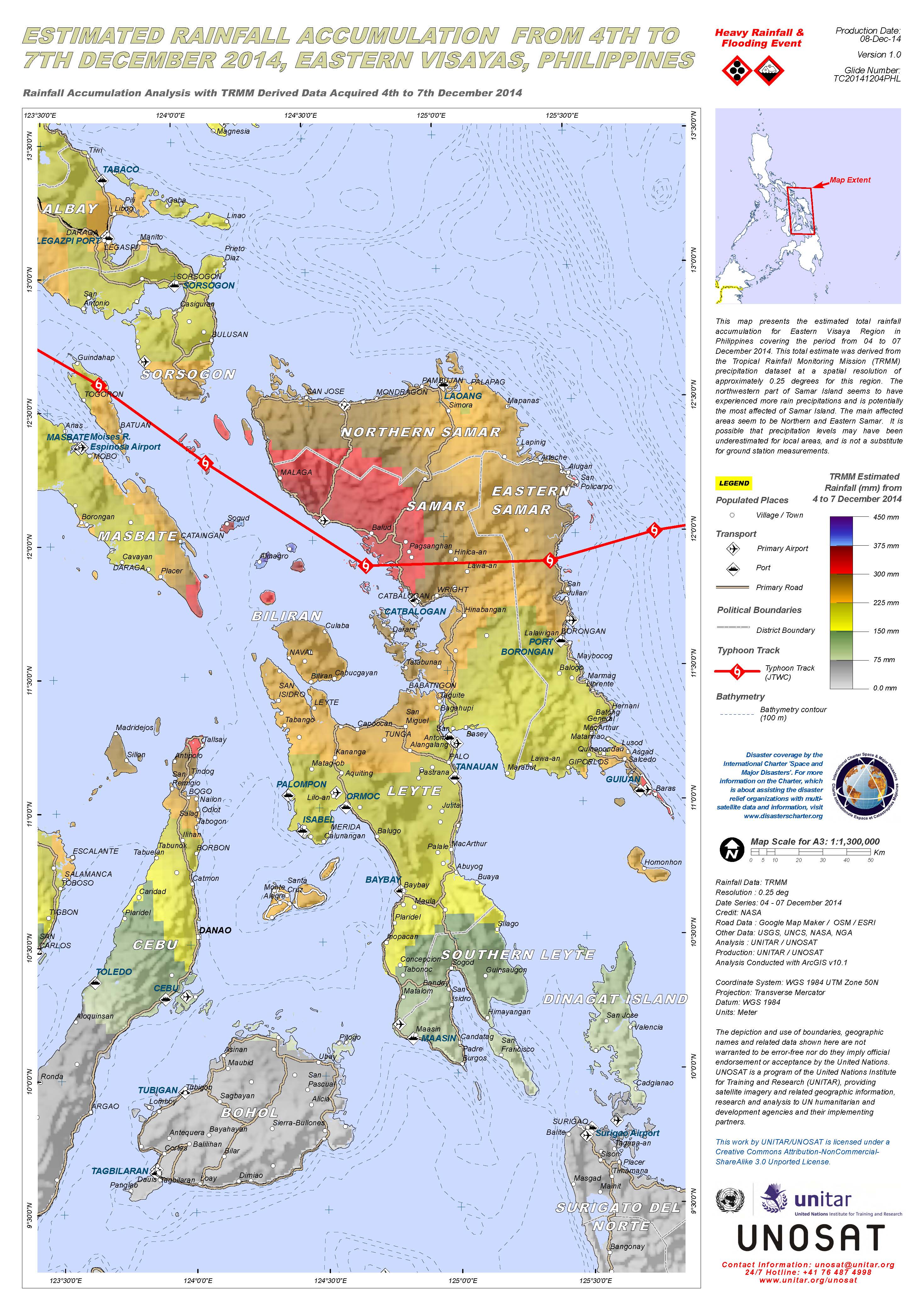
Estimated rainfall accumulation from Typhoon Hagupit over Eastern Visayas, the Philippines
版权: NASA
Map produced by UNITAR/UNOSAT
Information about the Product
已获得: 04/12/2014-07/12/2014
源: TRMM
 返回完整的响应档案

