 English
 Spanish
 French
 Chinese
 Russian
 Portuguese
 最新宪章启动
Charter activations
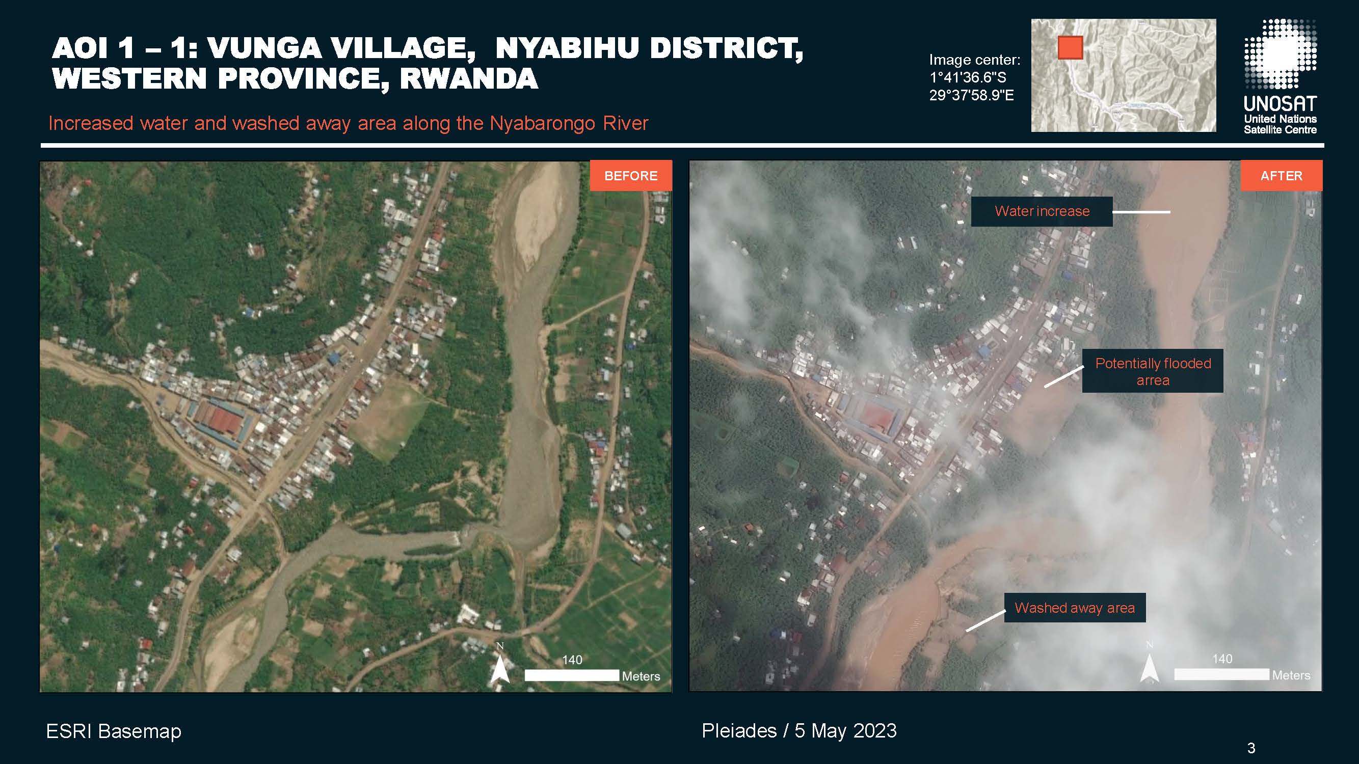
Flooding in Rwanda
In early May, torrential rainfall triggered flooding and landslides in many parts of Rwanda which is considered one of the most climate-impacted nations on Earth. The hardest-hit districts were Ngororero, Rubavu, Nyabihu, Rutsiro and Karongi.
At least 130 people died while thousands were displaced as several villages were inundated and buildings destroyed. 5000 homes, 17 roads (Including the Mukamira-Ngororero and Rubavu-Rutsiro roads which were impassable due to landslide debris), 26 bridges and a hospital were lost during the severe flooding.
Rwanda is one of the most densely populated countries in Africa. 65% of the population is employed in the agricultural industry. However, as more usable land is being eroded and degraded due to heavy rain and flooding, a majority is vulnerable to losing their occupation due to climate change. This vulnerability will only grow as, currently, Africa is warming up at almost twice the global average.
The National Meteorology Agency said above-average rainfall was expected in many parts of the country during the first 10 days of May following a period of drought. From January to April, 60 people died in weather-related disasters and many houses and acres of land across the country were destroyed. The hilly landscapes of the western and Northern provinces of the country and the capital, Kigali, make them vulnerable to landslides during the rainy season.
| 事件类型: | Floods |
| 事件地点: | Rwanda |
| 启动宪章的日期: | 2023-05-04 |
| 宪章启动时间: | 19:31 |
| 宪章启动时区: | UTC+02:00 |
| 宪章要求者: | UNITAR on behalf of United Nations Office for the Coordination of Humanitarian Affairs (OCHA) / Regional Office for Southern & Eastern Africa |
| 启动ID: | 816 |
| 项目经理: | Zachary Foltz (Argans) |
| act-value-adders: | Jakrapong Tawala (UNITAR) Yves Hategekimana (Rwanda Space Agency) |
Products
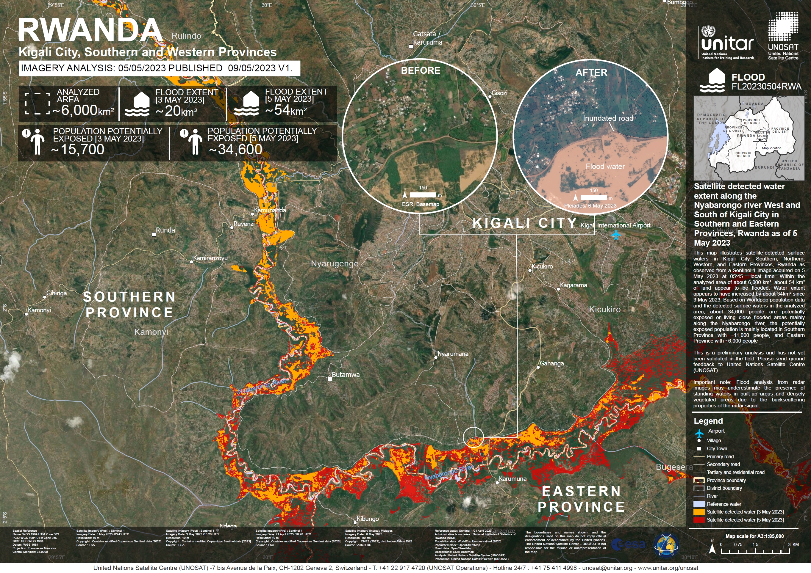
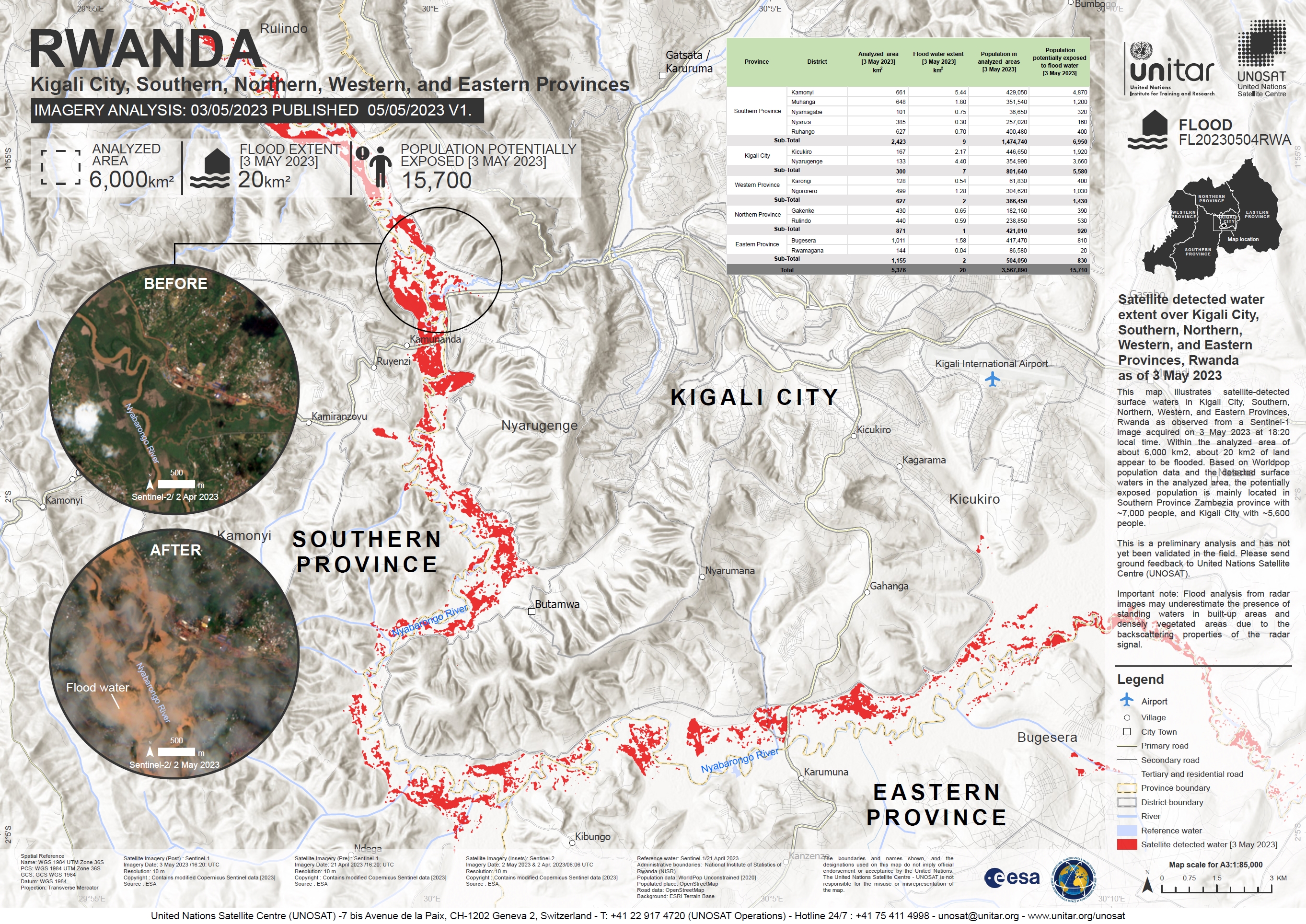
Satellite Detected Water Extent along the Nyabarongo River, West and South of Kigali City in the Southern and Eastern Provinces, Rwanda
版权: Contains modified Copernicus Sentinel data (2023)
Includes Pleiades material © CNES (2023), Distribution Airbus DS.
Map produced by UNOSAT and UNITAR.
Information about the Product
已获得: Sentinel-1: 21/04/2023, 03/05/2023 and 05/05/2023
Pleiades: 06/05/2023
源: Sentinel-1 and Pleiades
类别: Delineation Map
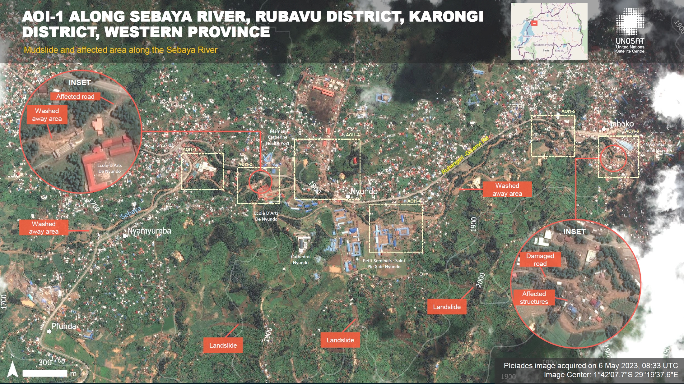
Preliminary Satellite Flood and Landslide Assessment Report along the Sebaya River, Rubavu District and Karongi District Western Province, Rwanda
Download Full Report
版权: © (2023) DigitalGlobe, Inc., Longmont CO USA 80503. DigitalGlobe and the DigitalGlobe logos are trademarks of DigitalGlobe, Inc.
The use and/or dissemination of this data and/or of any product in any way derived there from are restricted.
Unauthorised use and/or dissemination is prohibited
Includes Pleiades material © CNES (2023), Distribution Airbus DS.
Report produced by UNOSAT and UNITAR.
Information about the Product
已获得: WorldView-2: 04/07/2022
Pleiades: 06/05/2023
源: WorldView-2 and Pleiades
类别: Reference Map
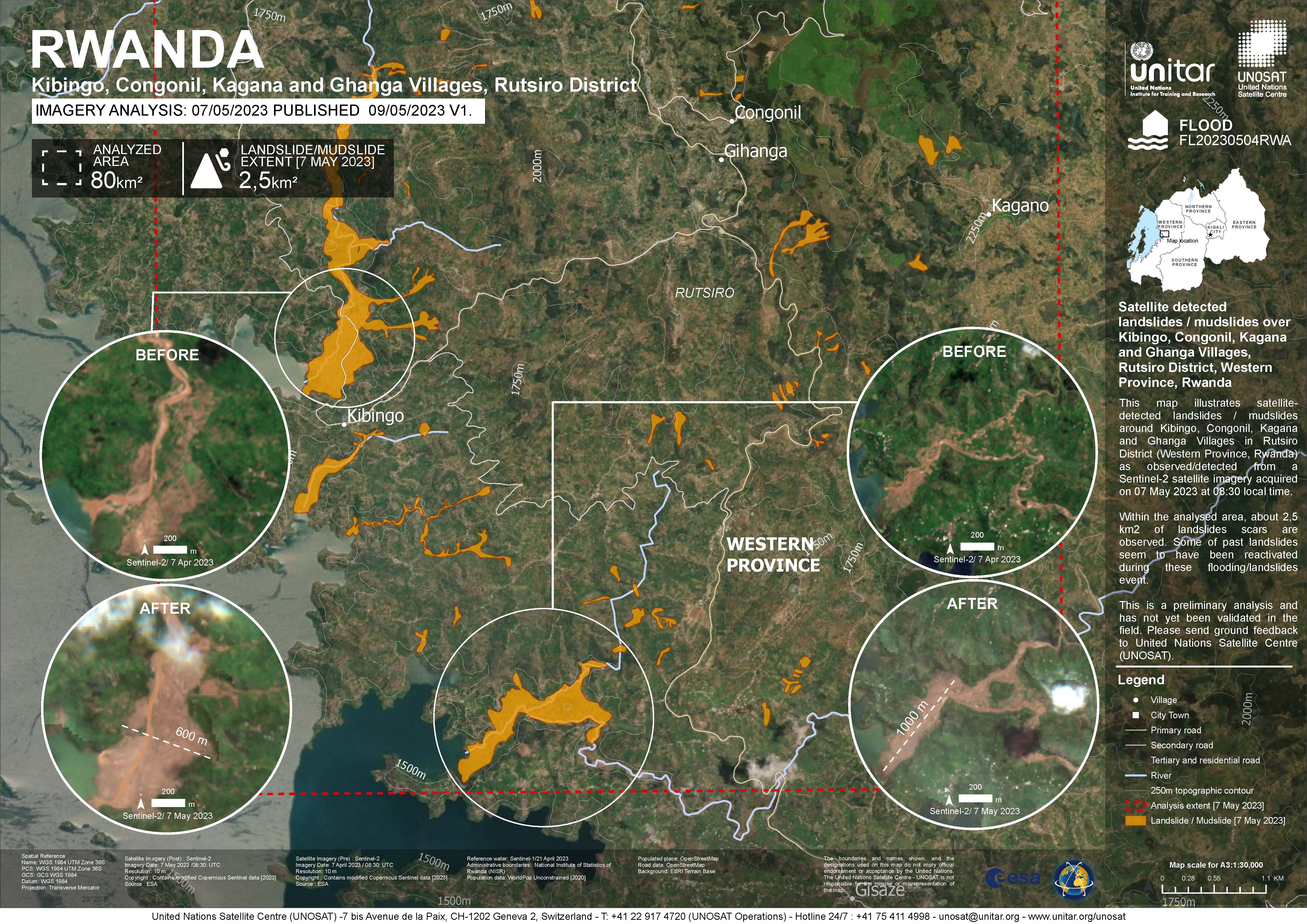
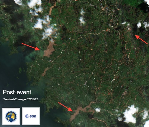
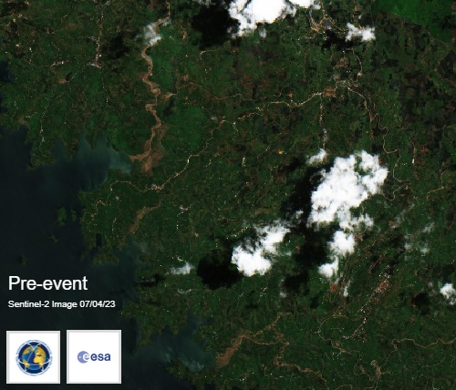
Satellite detected landslides / mudslides over Kibingo, Congonil, Kagana and Ghanga Villages, Rutsiro District, Western Province, Rwanda
版权: Contains modified Copernicus Sentinel data (2023)
Map produced by UNITAR / UNOSAT
Information about the Product
已获得: 07/04/2023
07/05/2023
源: Sentinel-2
类别: Delineation Map
Preliminary Satellite Flood and Landslide Assessment Report, Rutsiro and Karongi Districts, Western Province, Rwanda
Download full report
版权: Includes Pleiades material © CNES (2023), Distribution Airbus DS.
Report prepared by UNITAR / UNOSAT
Information about the Product
已获得: 07/05/2023
源: Pleiades
类别: Dossier
Preliminary Satellite Flood Assessment Report, Nyabarongo River, Western, Northern, Southern Provinces and Kigali City, Rwanda
Download full report
版权: Includes Pleiades material © CNES (2023), Distribution Airbus DS.
Report prepared by UNITAR / UNOSAT
Information about the Product
已获得: 05/05/2023
源: Pleiades
类别: Reference Map
Quickviews
Quickviews are produced for illustration purposes only and do not contain any verified analysis of the disaster.
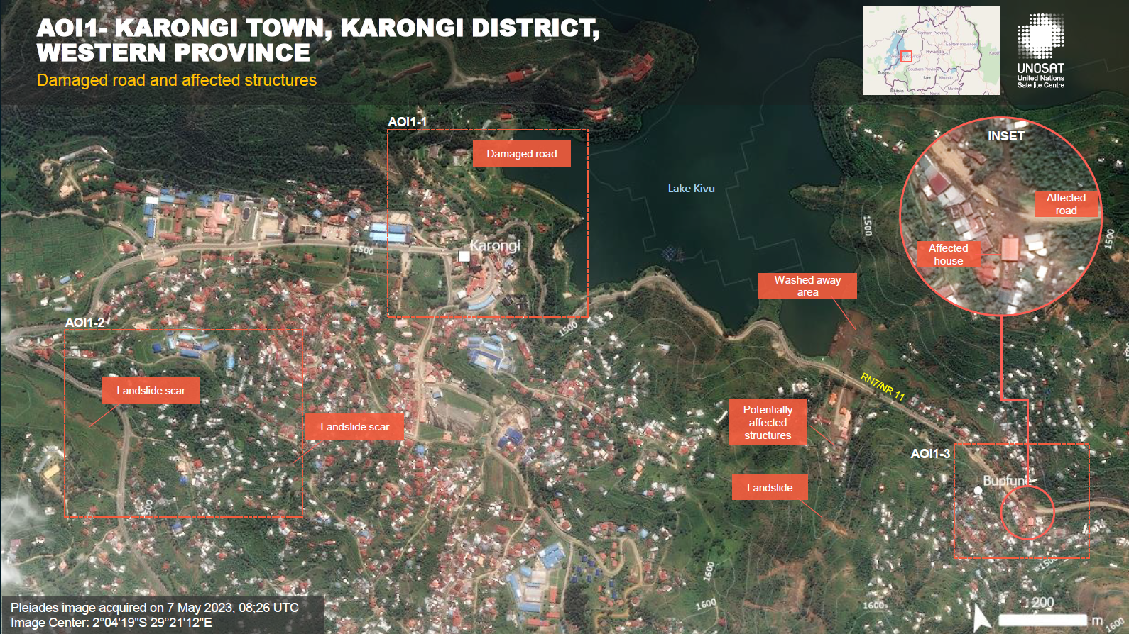
Possible mudslides/landslides near the village of Karongi in North-Western Rwanda
Copyrights: Contains modified Copernicus Sentinel data (2023)
Information about the Quickview
Acquired: 2023-04-07 / 2023-05-07
Source(s): Sentinel-2
 返回完整的响应档案

