 English
 Spanish
 French
 Chinese
 Russian
 Portuguese
 最新宪章启动
Charter activations
Hurricane Florence in the United States
Hurricane Florence is heading for the East Coast of America, with forecasters predicting it is to make landfall on 14 September in the Carolinas. The storm is currently category four and is expected to strengthen in the coming days.
Florence is the most powerful storm to threaten the Carolinas in almost thirty years with current sustained wind speeds of over 140mph. Forecasts predict as much as 20 inches of rain, and the region could be without power for several days. Storm surge is also predicted to flood large areas.
A state of emergency has already been declared in Virginia, Maryland, Washington DC as well as North and South Carolina. Officials have already asked residents in low-lying coastal areas to leave their homes with a million people expected to evacuate.
On the morning of 12 September Florence is still over 700 miles offshore but will remain extremely powerful until landfall.
Related News and Resources
- Products published by Copernicus EMS (Copernicus)
- A View Inside Hurricane Florence (NASA)
- Hurricane Florence (Planet)
- Copernicus Sentinel maps Florence hurricane flood (ESA)
- Evaluating Florence damage from the air: NOAA begins aerial surveys (NOAA)
- Hurricane Florence – DLR provides satellite information (DLR)
- USGS, AmericaView Connection Proves Valuable with Hurricane Florence (USGS)
| 事件类型: | Ocean Storm - Hurricane |
| 事件地点: | United States |
| 启动宪章的日期: | 2018-09-11 |
| 宪章启动时间: | 17:03 |
| 宪章启动时区: | UTC-05:00 |
| 宪章要求者: | US Geological Survey on behalf of US Federal Emergency Management Agency (FEMA) |
| 启动ID: | 585 |
| 项目经理: | University of Louisiana at Lafayette Regional Application Center (RAC) |
Products
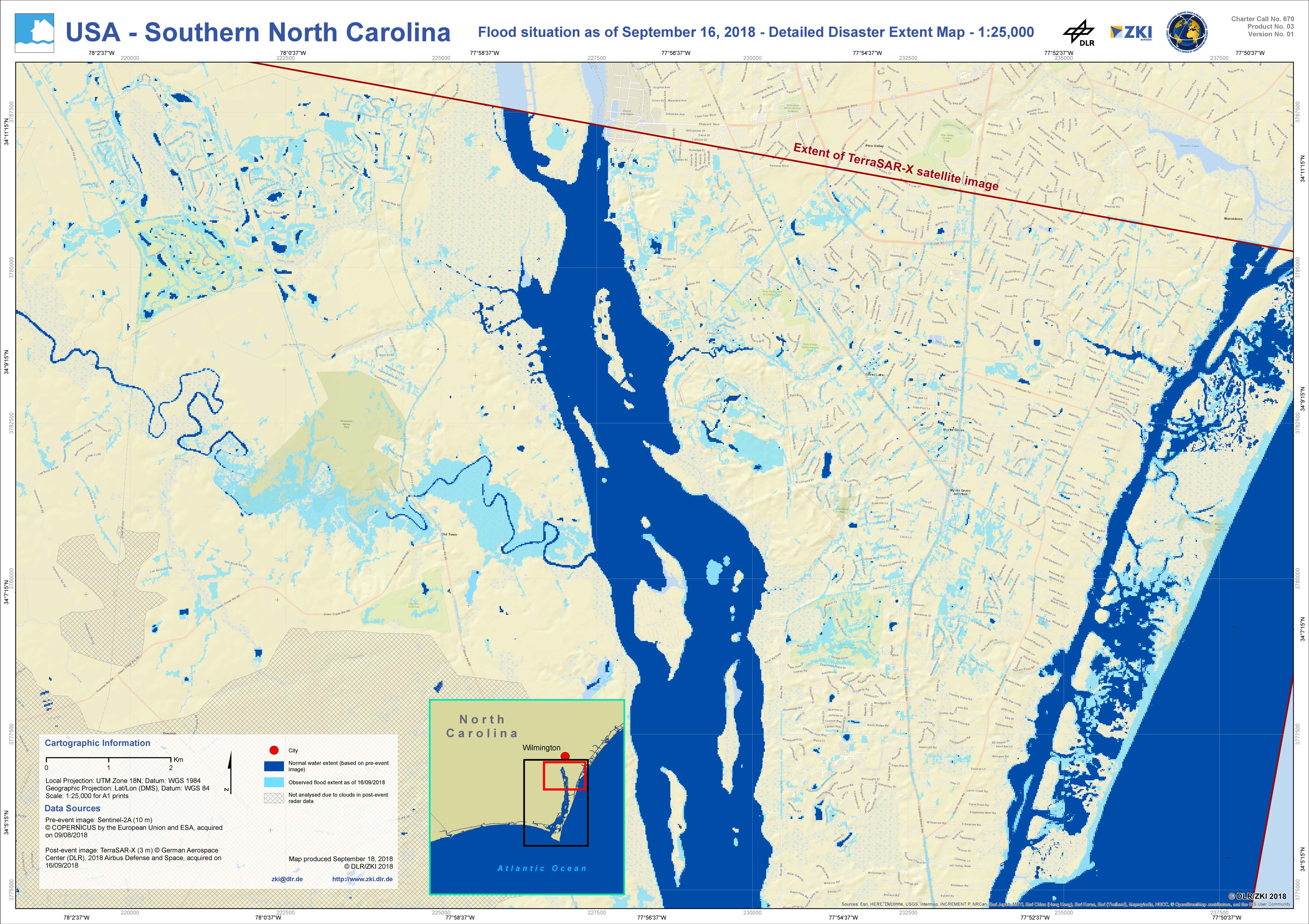
Southern North Carolina - Flood situation as of 16 September
版权: Sentinel-2 © Copernicus Sentinel data (2018)
TerraSAR-X © DLR e. V. 2018, Distribution: Airbus DS Geo GmbH
Map produced by DLR/ZKI
Information about the Product
已获得: Sentinel-2: 09/08/2018
TerraSAR-X: 16/09/2018
源: Sentinel-2 / TerraSAR-X
Flood extent map of the southern part of North Carolina after Hurricane Florence
版权: Sentinel-2 © Copernicus Sentinel data (2018)
TerraSAR-X © DLR e. V. 2018, Distribution: Airbus DS Geo GmbH
Map produced by DLR/ZKI
Information about the Product
已获得: Sentinel-2: 09/08/2018
TerraSAR-X: 16/09/2018
源: Sentinel-2 / TerraSAR-X

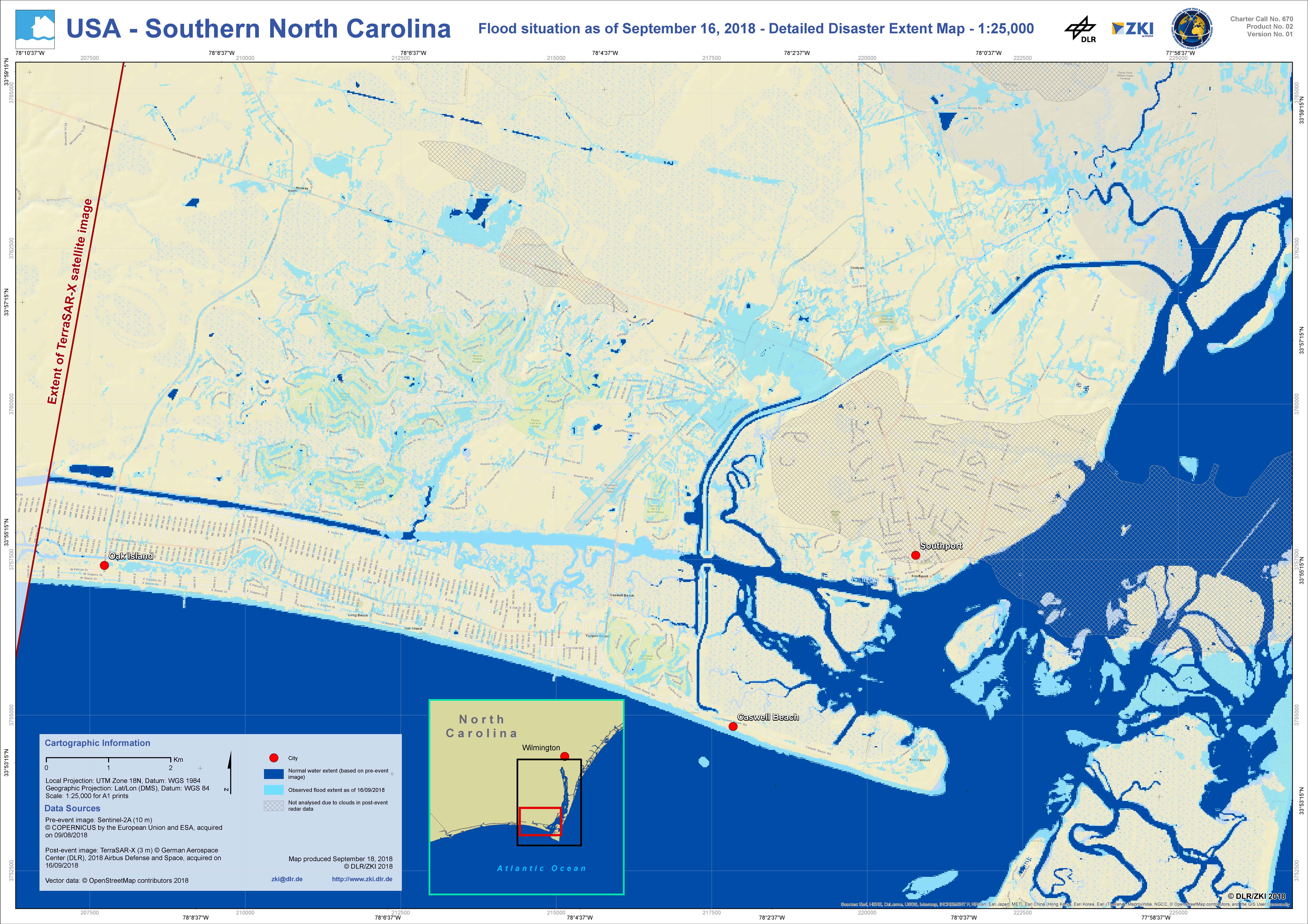
Southern North Carolina - Flood situation as of 16 September
版权: Sentinel-2 © Copernicus Sentinel data (2018)
TerraSAR-X © DLR e. V. 2018, Distribution: Airbus DS Geo GmbH
Map produced by DLR/ZKI
Information about the Product
已获得: Sentinel-2: 09/08/2018
TerraSAR-X: 16/09/2018
源: Sentinel-2 / TerraSAR-X
 返回完整的响应档案

