 English
 Spanish
 French
 Chinese
 Russian
 Portuguese
 Последняя Активация
Charter activations
Flood in Somalia
Flash floods in Somalia are now affecting over 460,000 people according to the United Nations Office for the Coordination of Humanitarian Affairs (OCHA).
Flooding began in March, after three years of drought, but in early May the Shabelle River burst its banks, flooding the town of Beledweyne in the centre of the country. The Food and Agriculture Organisation of the United Nations estimated that 79% of the city was flooded, and over 250,000 people were forced to evacuate their homes. It was described as the worst flooding the country has experienced since 1991.
22 people are reported to have been killed since March, and the floods have damaged both infrastructure and agriculture, washing away houses, crops and livestock.
Scientists have continuously warned of the consequences of climate change as the global temperature increases exponentially. Humanitarian emergencies have become more frequent and more people are falling victim to the climate crisis.
| Тип события: | Floods |
| Место события: | Somalia |
| Date of Charter Activation: | 2023-05-24 |
| Время активации Хартии: | 14:08 |
| TЧасовой пояс в районе активации Хартии: | UTC+02:00 |
| Запрос на активацию поступил от: | UNITAR on behalf of Food and Agriculture Organization of the United Nations (FAO) |
| Номер активации: | 821 |
| Менеждер проекта от: | Zachary Foltz (Argans) |
| act-value-adders: | Ida Svendsen (UNOSAT) Sandro Martinis (DLR) |
Products
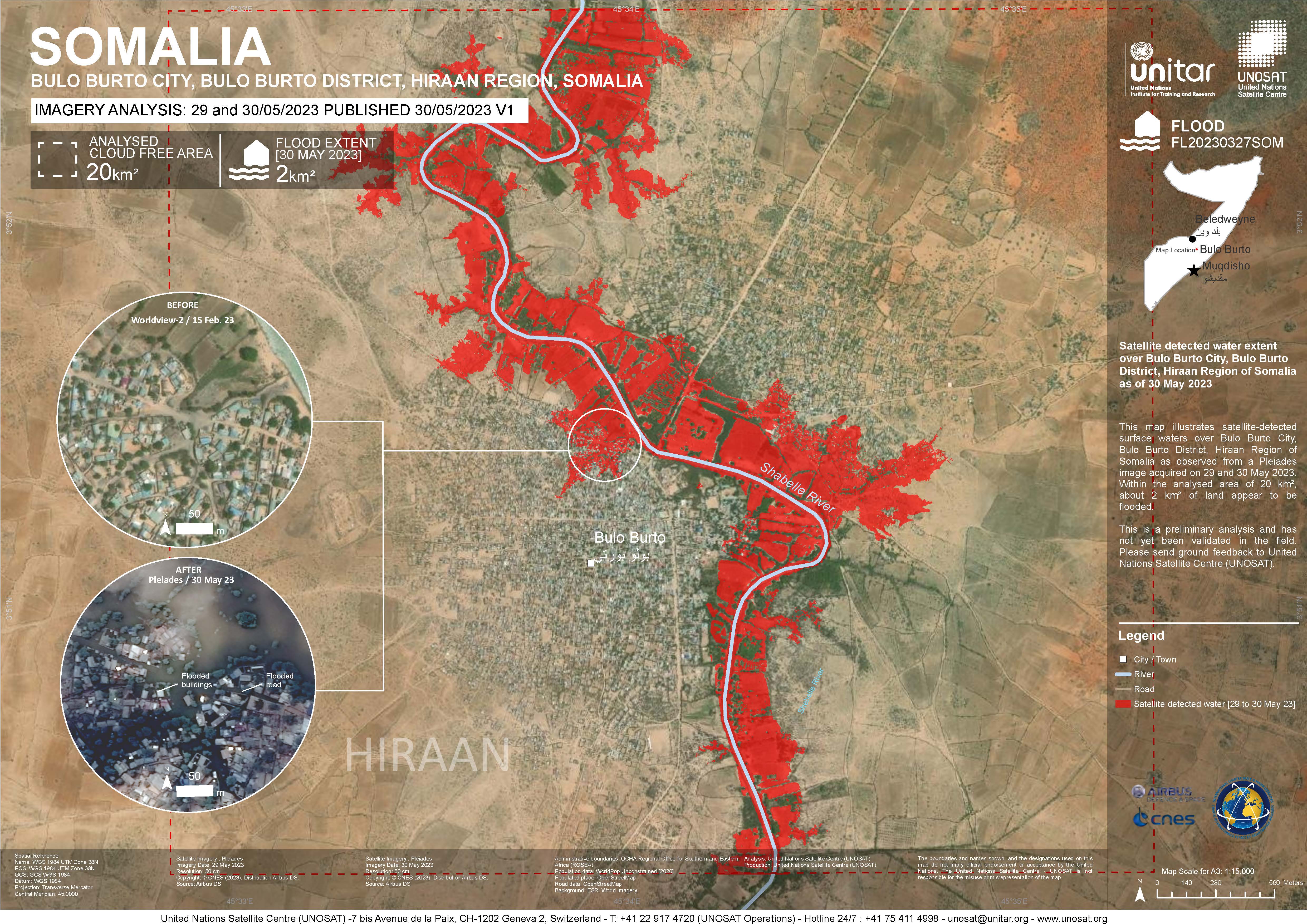
Satellite detected water extent over Bulo Burto City, Bulo Burto District, Hiraan Region of Somalia
Авторские права: Includes Pleiades material © CNES (2023), Distribution Airbus DS.
Map produced by UNITAR / UNOSAT
Information about the Product
Получено: 03/06/2023, 29/05/2023, 30/05/2023
Источник: Pleiades
Категория: Delineation Map
Preliminary Satellite Flood Assessment Report of Beledweyne City, Hirran Region and Jowhaar City, Middle Shabelle Region in Somalia
Download Full Report
Авторские права: Includes Pleiades material © CNES (2023), Distribution Airbus DS.
Contains modified Copernicus Sentinel data (2023)
Report produced by UNOSAT and UNITAR.
Information about the Product
Получено: Pleiades: 25/05/2023, 29/05/2023 and 30/05/2023
Sentinel-2: 29/05/2023
Источник: Pleiades and Sentinel-2
Категория: Delineation Map
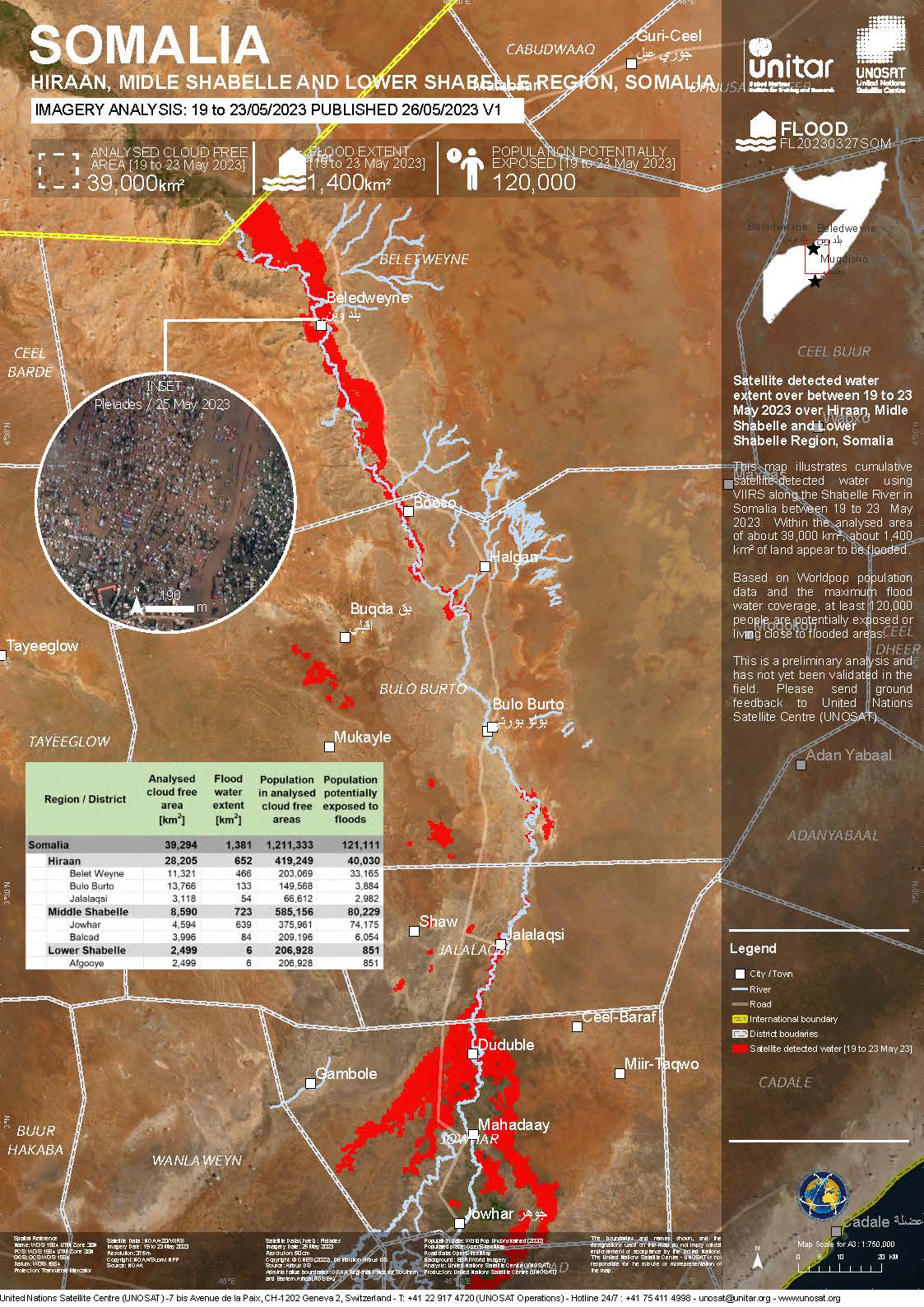
Satellite Detected Water Extent over Hiraan in the Middle Shabelle and Lower Shabelle Region, Somalia
Авторские права: NOAA/Suomi NPP
Pleiades © CNES (2023), Distribution Airbus D&S.
Map produced by UNOSAT and UNITAR.
Information about the Product
Получено: Suomi NPP: 28/05/2023
Pleiades: 29/05/2023
Источник: Suomi NPP and Pleiades
Категория: Delineation Map
Satellite detected water extent over Bulo Burto City, Bulo Burto District, Hiraan Region of Somalia
Авторские права: Includes Pleiades material © CNES (2023), Distribution Airbus DS.
Map produced by UNITAR / UNOSAT.
Information about the Product
Получено: 29/05/2023 and 30/05/2023
Источник: Pleiades
Категория: Delineation Map
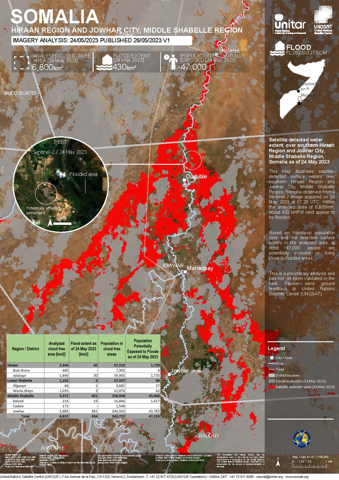
Satellite detected water extent over southern Hiraan Region and Jowhar CIty, Middle Shabelle Region, Somalia
Авторские права: Contains modified Copernicus Sentinel data (2023)
Map produced by UNITAR / UNOSAT
Information about the Product
Получено: 24/05/2023
Источник: Sentinel-2
Категория: Delineation Map
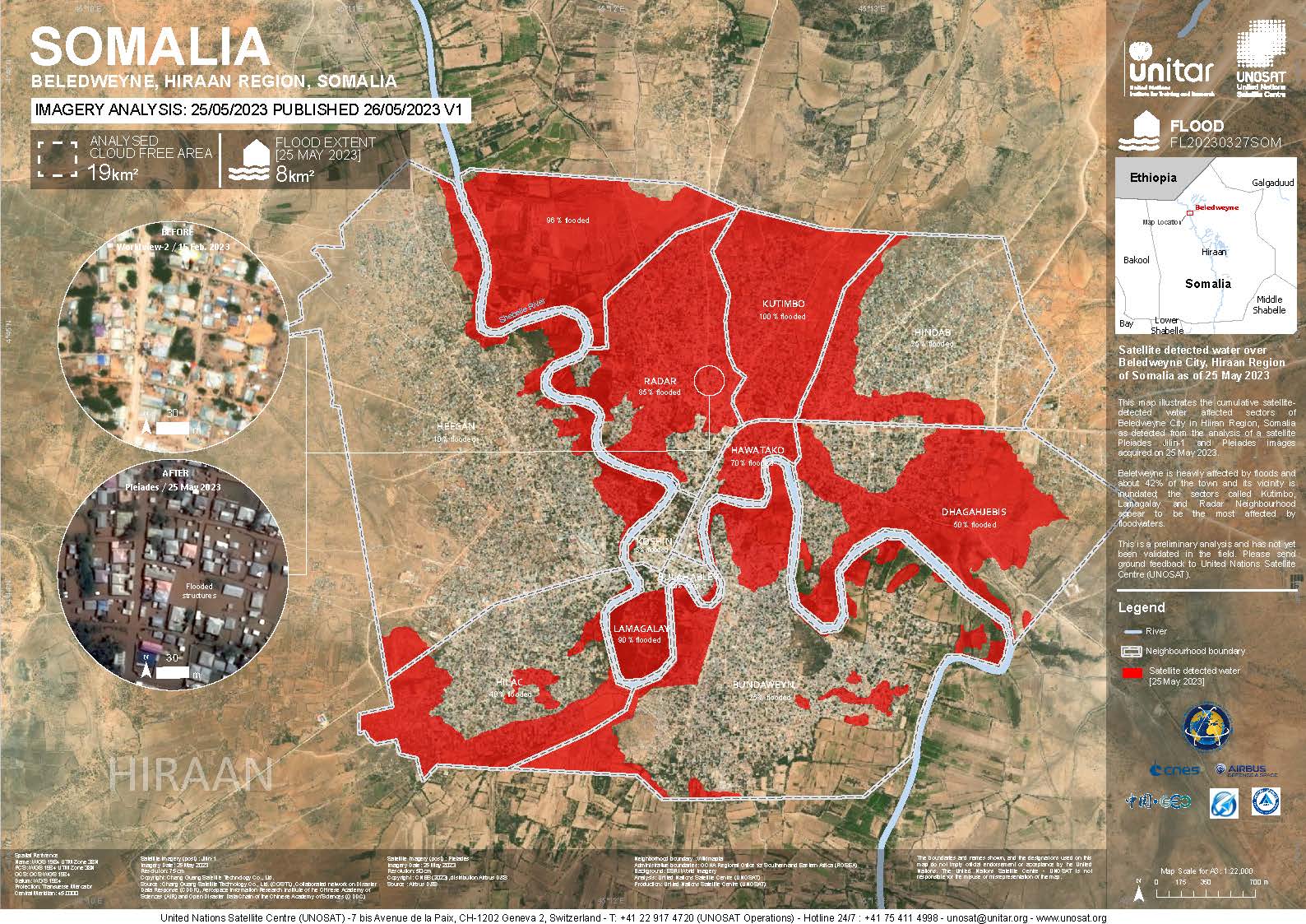
Satellite detected water over Beledweyne City, Hiraan Region of Somalia
Авторские права: JILIN-1 © 21AT (2023)
Includes Pleiades material © CNES (2023), Distribution Airbus DS.
Map produced by UNITAR/UNOSAT
Information about the Product
Получено: JILIN-01: 25/05/2023
Pleiades: 25/05/2023
Источник: JILIN-1 / Pleiades
Категория: Delineation Map
Satellite detected water extent over Hiraan, Midle Shabelle and Lower Shabelle Region, Somalia
Авторские права: Includes Pleiades material © CNES (2023), Distribution Airbus DS.
NOAA/Suomi NPP
Map produced by UNITAR/UNOSAT
Information about the Product
Получено: Pleiades: 25/05/2023
Suomi NPP: 23/05/2023
Источник: Pleiades / Suomi NPP
Категория: Delineation Map
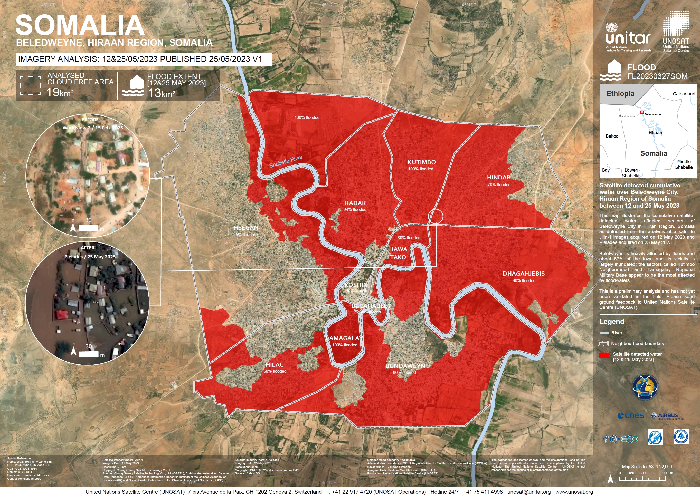
Satellite Detected Flooding over Beledweyne City in the Hiraan Region of Somalia
Авторские права: JILIN-1 Imagery © 21AT (2023)
Includes Pleiades material © CNES (2023), Distribution Airbus DS.
Map produced by UNOSAT and UNITAR.
Information about the Product
Получено: JILIN-1: 12/05/2023
Pleiades: 25/05/2023
Источник: JILIN-1 and Pleiades
Категория: Delineation Map
Quickviews
Quickviews are produced for illustration purposes only and do not contain any verified analysis of the disaster.
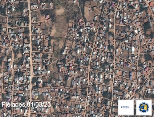
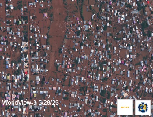
Pre and Post Flooding Images over the town of Beledweyne in Central Somalia, near the Ethiopian border.
Copyrights: Includes Pleiades material © CNES (2023), Distribution Airbus DS.
Worldview © (2023) DigitalGlobe, Inc., Longmont CO USA 80503. DigitalGlobe and the DigitalGlobe logos are trademarks of DigitalGlobe, Inc. The use and/or dissemination of this data and/or of any product in any way derived there from are restricted. Unauthorized use and/or dissemination is prohibited.
Information about the Quickview
Acquired: 2023-03-01 / 2023-05-28
Source(s): Pleiades / WorldView-3
 Вернуться к полному архиву активаций

