 English
 Spanish
 French
 Chinese
 Russian
 Portuguese
 Latest Activation
Charter activations
Sinabung Volcano in Indonesia
Mount Sinabung in Indonesia erupted on 21 May at 09:48 UTC (04:48 local time) and killed seven people in the nearby village of Gembar. The volcano is still erupting, pouring ash 3 km into the sky.
Sinabung is located on the island of Sumatra and claimed a dozen lives when it last erupted in 2014. In October of that year, following the most recent eruption, a 4 km danger zone was declared around the volcano. Residents were urged to avoid this zone due to the risk posed by further eruptions of the volcano, which is one of the most active in Indonesia. But Indonesia's National Disaster Management Agency have reported that some residents do occasionally enter the zone to check on their homes and farms. Any residents who have chosen to remain in the zone have again been urged to evacuate immediately.
The seven victims caught in this eruption were tending a farm in Gembar village, and two more have been left in a critical condition after the village was blanketed in ash clouds and gas.
Rescue teams are searching the area to try and find any other victims of the eruption, but it is unclear how many people may have been within the zone at the time of the eruption. The continuing eruption is also making it difficult for the search teams to safely venture into the area, as the clouds of ash pose a hazard.
The highest alert level is currently in place due to the risk of further activity from Mount Sinabung.
| Type of Event: | Volcano |
| Location of Event: | Indonesia |
| Date of Charter Activation: | 23 May 2016 |
| Time of Charter Activation: | 09:42:58 |
| Time zone of Charter Activation: | UTC+02:00 |
| Charter Requestor: | ADRC on behalf of LAPAN |
| Project Management: | LAPAN |
Products
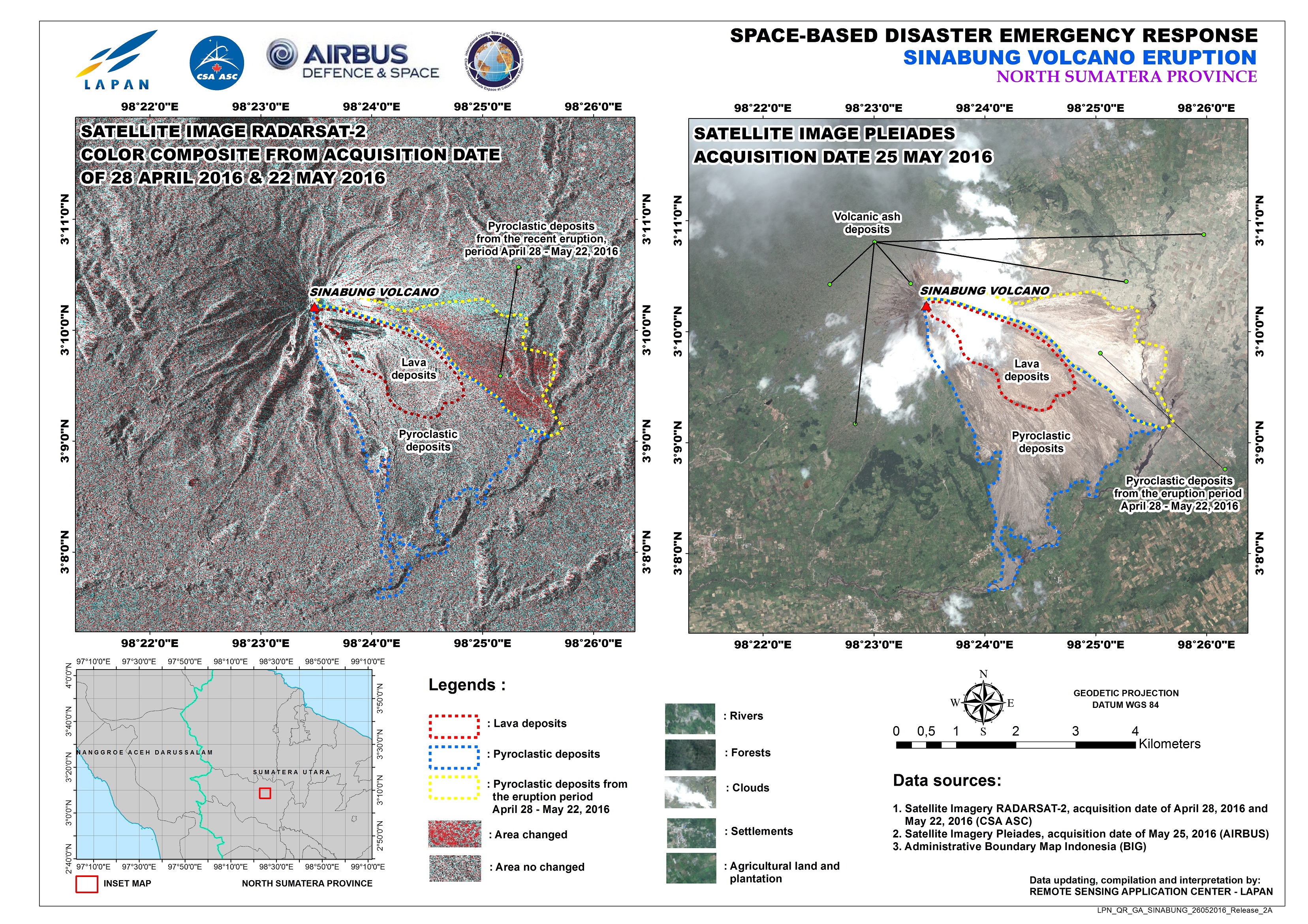
Sinabung Volcano assessment, North Sumatra province, Indonesia
Copyright: RADARSAT-2 Data and Products © MacDonald, Dettwiler and Associates Ltd. (2016) - All Rights Reserved. RADARSAT is an official trademark of the Canadian Space Agency.
Pleiades © CNES 2016 - Distribution: Airbus Defence and Space, all rights reserved
Map produced by LAPAN
Information about the Product
Acquired: RADARSAT-2: 28/04/2016 and 22/05/2016
Pleiades: 25/05/2016
Source: RADARSAT-2 / Pleiades
 Back to the full activation archive

