Charter activations
Super Typhoon Man-yi in the Philippines
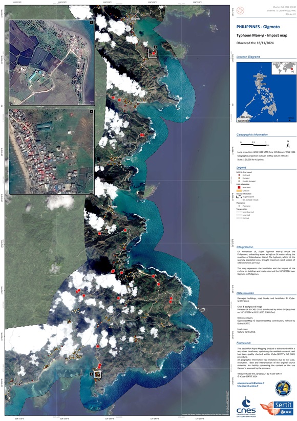
Super Typhoon Man-yi ( known locally as Pepito) hit the Philippines on 16 November, with waves up to 14 metres (46 feet) high battering the coastline of Catanduanes Island. The typhoon brought maximum wind speeds of 195 kilometers (121 miles) per hour as it impacted the sparsely populated island.
Man-yi triggered a mass evacuation, with more than 650,000 people fleeing their homes before it made landfall. Many sought refuge in schools, malls, and evacuation centers. Some took shelter in school classrooms, which were hot and cramped but safe. Around 400 people were squeezed into the provincial government building in the capital, Virac, with new arrivals being sent to a gymnasium.
Catanduanes Island was left without power after the storm knocked down trees and electricity posts. Other damages included homes with roofs blown off, a small kiosk shop was completely lifted off its foundation.
Typhoon Man-yi then swept across Luzon, the Philippines' main island, on Sunday, 17 November 2024, bringing heavy rainfall to the capital region, Metro Manila.
At least 163 people have died in the five storms that hit the Philippines in recent weeks, leaving thousands homeless and wiping out crops and livestock.
| Type of Event: | Storm |
| Location of Event: | Philippines |
| Date of Charter Activation: | 2024-11-17 |
| Time of Charter Activation: | 20:39 |
| Time zone of Charter Activation: | UTC+07:00 |
| Charter Requestor: | UNOSAT on behalf of United Nations Office for the Coordination of Humanitarian Affairs (OCHA) Regional Office for Asia and the Pacific, Bangkok |
| Activation ID: | 930 |
| Project Management: | Jakrapong Tawala (UNITAR) |
| Value Adding: | Konstantin Homenkov (Geoniformation systems) SERTIT Rapid Mapping Service Shaikha Ahmed Albesher (Mohammed Bin Rashid Space Centre) |
Products

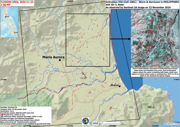
Flood situation in Philippines, Camarines Norte, Daet.
Copyright: USGS/NASA Landsat Program
Contains modified Copernicus Sentinel data (2024)
Map produced by Geo-Information Systems
Information about the Product
Acquired: Landsat-9: 18/11/2024, Sentinel-2: 04/12/2024
Source: Landsat-9, Sentinel-2
Category: Delineation Map

Preliminary satellite-derived impact assessment in Aurora Province, Central Luzon Region, The Philippines
Download full report
Copyright: Includes material © AIRBUS DS (2024)
© NTs OMZ, All Rights Reserved
Report produced by UNITAR / UNOSAT
Information about the Product
Acquired: PNEO4: 21/11/2024, Kanopus-V: 23/11/2024, PNEO3: 24/11/2024, Resures-P: 24/11/2024
Source: PNEO3 / PNEO4 / Kanopus-V / Resures-P
Category: Dossier

Building Damage Assessment in Panay Island, Catanduanes Province, Bicol Region, The Philippines
Copyright: Includes Pleiades material © CNES (2024), Distribution Airbus DS.
Map produced by UNITAR / UNOSAT
Information about the Product
Acquired: 18/11/2024, 20/11/2024
Source: Pleiades
Category: Grading Map

Building Damage Assessment in Bacak Village, Catanduanes Province, Bicol Region, The Philippines
Copyright: Includes Pleiades material © CNES (2024), Distribution Airbus DS.
Map produced by UNITAR / UNOSAT
Information about the Product
Acquired: 18/11/2024, 20/11/2024
Source: Pleiades
Category: Grading Map

Building Damage Assessment in Panganiban City, Catanduanes Province, Bicol Region, The Philippines
Copyright: Includes Pleiades material © CNES (2024), Distribution Airbus DS.
Map produced by UNITAR / UNOSAT
Information about the Product
Acquired: 18/11/2024, 20/11/202
Source: Pleiades
Category: Grading Map

Building Damage Assessment in Bagamanoc City, Catanduanes Province, Bicol Region, The Philippines
Copyright: Includes Pleiades material © CNES (2024), Distribution Airbus DS.
Map produced by UNITAR / UNOSAT
Information about the Product
Acquired: 18/11/2024, 20/11/2024
Source: Pleiades
Category: Grading Map

Preliminary satellite-derived impact assessment, Camarines Sur and Camarines Norte Provinces, Bicol Region, The Philippines
Download full report
Copyright: Contains modified Copernicus Sentinel data (2024)
Includes Pleiades material © CNES (2024), Distribution Airbus DS.
Report produced by UNITAR / UNOSAT
Information about the Product
Acquired: Pleiades: 18/11/2024, Sentinel-2: 19/11/2024
Source: Sentinel-2, Pleiades
Category: Dossier

Preliminary satellite-derived impact assessment, Catanduanes Province, Bicol Region, The Philippines
Download full report
Copyright: Includes Pleiades material © CNES (2024), Distribution Airbus DS.
RADARSAT Constellation Mission Imagery © Government of Canada (2024) - RADARSAT is an official mark of the Canadian Space Agency
Map produced by UNITAR / UNOSAT
Information about the Product
Acquired: Pleiades: 18/11/2024
RCM: 18/11/2024
Source: Pleiades / RCM
Category: Dossier

Flood situation in Camarines Norte, Daet, Philippines
Copyright: USGS/NASA Landsat Program
Includes Pleiades material © CNES (2024), Distribution Airbus DS.
Map produced by UE "Geoinformation systems"
Information about the Product
Acquired: Landsat 9: 18/11/2024
Pleiades: 18/11/2024
Source: Landsat 9 / Pleiades
Category: Reference Map
 Back to the full activation archive

 English
 Spanish
 French
 Chinese
 Russian
 Portuguese


