Minimize Latest Activation

Charter activations

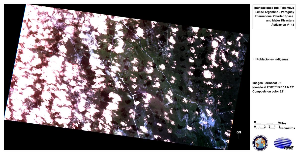
Floods in Bolivia-Paraguay-Argentina

Exceptional water level rise up to 9.7 m and water discharge (~ 11,000 m3/s) triggered permanent alert in Formosa (Argentina) with evacuations in the towns of María Cristina and Lote Ocho. About one hundred families have been isolated in the north east of Salta (Argentina) and massive evacuations have taken place in Bolivia as well.  

Type of Event:Floods
Location of Event:Bolivia-Paraguay-Argentina
Date of Charter Activation:19/01/2007 22:34 UTC
Charter Requestor:SIFEM Argentina
Project Management:CONAE

Products

Landsat-5, roads, vegetation, water, villages.

Copyright: USGS 2007 Image processing, map created 31/01/2007 by CONAE.

Information about the Product

Acquired: 21/01/2007

Source: Landsat-5

Landsat-5, NW Pilcomayo, Normalised differential water index.

Copyright: USGS 2007 Image processing, map created 31/01/2007 by CONAE.

Information about the Product

Acquired: 10/01/2007

Source: Landsat-5

Landsat-5, Normalised differential water index.

Copyright: USGS 2007 Image processing, map created 31/01/2007 by CONAE.

Information about the Product

Acquired: 10/01/2007

Source: Landsat-5

Landsat-5, Pilomayo River SE

Copyright: USGS 2007 Image processing, map created 31/01/2007 by CONAE.

Information about the Product

Acquired: 10/01/2007

Source: Landsat-5

Landsat-5, Pilomayo River SE

Copyright: USGS 2007 Image processing, map created 31/01/2007 by CONAE.

Information about the Product

Acquired: 10/01/2007

Source: Landsat-5

Landsat-5, Normalised differential water index.

Copyright: USGS 2007 Image processing, map created 31/01/2007 by CONAE.

Information about the Product

Acquired: 10/01/2007

Source: Landsat-5

Landsat-5, SE Pilcomayo, Normalised differential water index.

Copyright: USGS 2007 Image processing, map created 31/01/2007 by CONAE.

Information about the Product

Acquired: 10/01/2007

Source: Landsat-5

ASAR Road network, water bodies Radar image, in overlay, roads, water bodies, villages.

Copyright: ESA 2007 Image processing, map created 25/01/2007 by CONAE.

Information about the Product

Acquired: 24/01/2007

Source: Envisat ASAR

Formosat, 23/01/2007 Rio Pilcomayo

Copyright: NSPO Taiwan 2007 Image processing, map created 28/01/2007 by CONAE.

Information about the Product

Acquired: 23/01/2007

Source: Formosat-2

DMC, 27/01/2007 Rio Pilcomayo

Copyright: DMC International Imaging 2007 Image processing, map created 28/01/2007 by CONAE.

Information about the Product

Acquired: 27/01/2007

Source: DMC

NOAA-17 Rio Pilcomayo basin

Copyright: NOAA 2007 Image processing, map created 28/01/2007 by CONAE.

Information about the Product

Acquired: 23/01/2007

Source: NOAA-17

IRS, 12/01/2007 Rio Pilcomayo

Copyright: NRSA India 2007 Image processing, map created 28/01/2007 by CONAE.

Information about the Product

Acquired: 12/01/2007

Source: IRS-P6 AWiFS

SPOT, 22/01/2007 Rio Pilcomayo Flooding of the Pilcomayo River.

Copyright: CNES 2007
Image processing, map created 25/01/2007 by CONAE.

Information about the Product

Acquired: 22/01/2007

Source: SPOT-5

Landsat-5 TM Bands 7-5-3, Rio Pilcomayo

Copyright: USGS 2007 Image processing, map created 28/01/2007 by CONAE.

Information about the Product

Acquired: 10/01/2007

Source: Landsat-5

Palsar, 20/01/2007 Rio Pilcomayo Radar image, in overlay, roads, water bodies, villages.

Copyright: JAXA 2007 Image processing, map created 25/01/2007 by CONAE.

Information about the Product

Acquired: 20/01/2007

Source: ALOS Palsar

Formosat, 23/01/2007 Rio Pilcomayo

Copyright: NSPO Taiwan 2007 Image processing, map created 28/01/2007 by CONAE.

Information about the Product

Acquired: 23/01/2007

Source: Formosat-2

FORMOSAT, 26/01/2007 Rio Pilcomayo

Copyright: NSPO Taiwan 2007 Image processing, map created 28/01/2007 by CONAE.

Information about the Product

Acquired: 26/01/2007

Source: Formosat-2

FORMOSAT, 26/01/2007 Rio Pilcomayo

Copyright: NSPO Taiwan 2007 Image processing, map created 28/01/2007 by CONAE.

Information about the Product

Acquired: 26/01/2007

Source: Formosat-2

SAC-C, Rio Pilcomayo Water, vegetation, bare soil indexes.

Copyright: CONAE 2007 Image processing, map created 28/01/2007 by CONAE.

Information about the Product

Acquired: 23/01/2007

Source: SAC-C, NDWVI

Reference image. Rio Pilcomayo

Copyright: NRSA India 2007 Image processing, map created 28/01/2007 by CONAE.

Information about the Product

Acquired: 25/01/2004

Source: IRS-P6 LISS

Radar image composition showing surface water, Rio Pilcomayo

Copyright: CSA 2007 Image processing, map created 30/01/2007 by CONAE.

Information about the Product

Acquired: 23-24/01/2007

Source: RADARSAT-1

Multitemporal/difference radar image showing surface water, Rio Pilcomayo

Copyright: CSA 2007 Image processing, map created 30/01/2007 by CONAE.

Information about the Product

Acquired: 23-24/01/2007

Source: RADARSAT-1

Sac C, 21/01/2007 Rio Pilcomayo Flooding along the Argentine-Paraguay border.

Copyright: CONAE 2007 Image processing, map created 25/01/2007 by CONAE.

Information about the Product

Acquired: 21/01/2007

Source: SAC-C

Back to the full activation archive