Charter activations
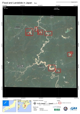
Flood and landslide in Japan
Typhoon Talas hit Kinki and Shikoku regions, Japan, on Saturday. The typhoon passed into the Sea of Japan on Sunday. At least 26 people have died and 55 people are missing after the storm. An emergency task-force rescue effort has been set up by the government, but figures are on a constant rise as several prefectures have been affected by the storm.
On Sunday, 460,000 evacuation orders were issued as the typhoon swept through the region; entire villages were flooded, whilst bridges and homes had been destroyed.
Japan's Meteorological Agency warned that heavy rains and strong winds would continue increasing the threat of more floods and landslides.
| Type of Event: | Floods, Landslides |
| Location of Event: | Gojyo-shi, Nara-pref, Japan |
| Date of Charter Activation: | 04/09/2011 |
| Charter Requestor: | Atsushi ONO/JAXA on behalf of Cabinet Office, Japan |
Products

Flood and landslide in Japan
Copyright: TerraSAR-X: German Aerospace Center (DLR) 2011- Commercial exploitation rights: Infoterra
RADARSAT-2 Data and Products © MacDonald, Dettwiler and Associates Ltd. (2011) - All Rights Reserved. RADARSAT is an official trademark of the Canadian Space Agency.
Map produced by JAXA
Information about the Product
Acquired: TerraSAR-X: 19/02/2011, 09/09/2011
RADARSAT-2: 11/08/2010, 06/09/2011
Source: TerraSAR-X / RADARSAT-2
 Back to the full activation archive

 English
 Spanish
 French
 Chinese
 Russian
 Portuguese


