English
 Spanish
 French
 Chinese
 Russian
 Portuguese
Technological disasters monitoring on a large scale
News
21 September 2020
Technological disasters monitoring on a large scale
The International Charter on Space and Major Disasters monitors the most common forms of natural disasters such as floods, earthquakes, landslides, cyclones and so on, but there are other types of disasters, which also benefit from satellite observations.
Technological disasters may occur in the event of a train or aircraft crash, or an accident at a factory, power plant or other large scale infrastructure. Satellite observations can be used to map the extent of the disaster area for first responders. Satellite imagery may also be used to help in the search for missing ocean-going vessels or aircraft, but this is very challenging. Unless there is a distinct area to start a search for a missing craft, the searching area could be anywhere in the ocean and it is impossible to find a lone craft in a vast ocean.
On the occasion of the 20th anniversary of the Charter, we take the opportunity to look back on examples of how the Charter has helped in some of these disasters.
One of the most recent industrial accidents that the Charter responded to is the explosion that occurred in the Port of Beirut, the capital city of Lebanon, at 18:08 local time (15:08 UTC) on August 4, 2020. It was caused by the explosion of a large quantity - 2,750 tons - of ammonium nitrate at a warehouse in the port. The explosion damaged half of Beirut and left at least 190 people dead and 300,000 homeless. It was so powerful that the United States Geological Survey registered it as a 3.3 magnitude earthquake. France (Centre Opérationnel de Gestion Interministérielle des Crises) activated the Charter on August 5. Satellite imagery acquired after the explosion showed a large crater where the warehouse had been and revealed damage to the port area. The Orient Queen, a cruise ship that was docked in port, was badly damaged and capsized on August 5.
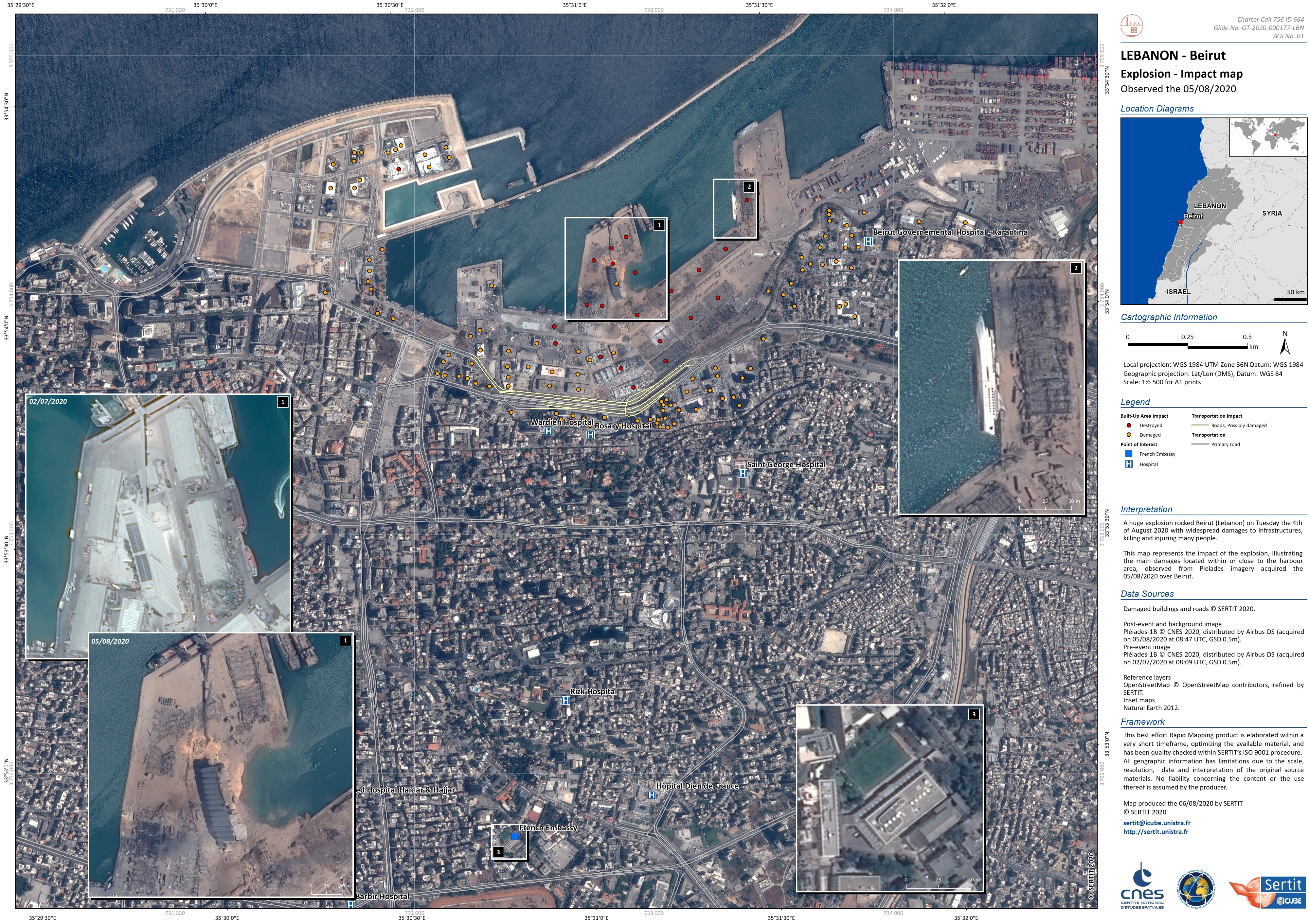
Industrial accident in Beirut (Lebanon) - Impact map. Pleiades image acquired on 08/05/2020. Copyright: Includes Pleiades material © CNES (2020), Distribution Airbus DS. Map produced by SERTIT
Other types of technological disasters that the Charter responded to include the recent oil spills in Mauritius (August 2020) and Russia (June 2020), two dam collapses in Brazil (January 2019 and November 2015), and the well-known Deepwater Horizon oil spill in the Gulf of Mexico (2010), which was also covered in a previous article in April 2020.
On April 20, 2010, an explosion occurred on the Deepwater Horizon oil platform, 70 km off the coast of Louisiana. The disaster was the result of a wellhead blowout, which killed 11 people and after two days of fires, caused the platform to sink on 22 April. Oil from the platform spilled into the Gulf of Mexico, causing the largest oil spill in U.S. history. United States Geological Survey (USGS) on behalf of the US Coast Guard requested to activate the Charter on April 22 and the National Oceanic and Atmospheric Administration (NOAA) provided a project manager. The satellite images that the Charter provided were used to observe the scope of the oil spill and help clean up efforts identify affected areas. The imagery was also able to help analysts anticipate where the oil would go by tracking its diffusion path, and take preventative measures.
Oil Spill in the Gulf of Mexico. Envisat image acquired on 04/25/2010. Copyright: ESA
The search and rescue of missing ocean-going vessels or aircraft is also an important part of industrial disaster response. The Charter first responded to a search of a missing aircraft in March 2014 for Malaysia Airlines Flight MH370. This flight, carrying 239 people (12 crew and 227 passengers) departed from Kuala Lumpur at 16:41 UTC on March 7 and was scheduled to arrive in Beijing at 22:30, but Vietnamese air traffic controllers lost contact with the aircraft at 17:30 (01:30 local time).
An international search began for the aircraft in the South China Sea, the last known location of the jet, and the search area later expanded to the Malacca Strait and the Indian Ocean. China Meteorological Administration requested to activate the Charter and provided a Project Manager to coordinate the mapping efforts. Though the Charter was not able to locate the aircraft great efforts were made during the search. Satellite imagery was employed to search for any evidence of the plane, both before and after it disappeared. China utilized 10 of its satellites to image the search area. The United States imaging corporation, DigitalGlobe, started a crowdsourcing campaign in which over two million volunteers studied DigitalGlobe images of the area. Satellite images revealed suspected debris and an oil spill that might have been caused by the crashed aircraft in a number of locations, but despite efforts to search an area of the southern Indian Ocean no trace of the plane was found.

Possible debris of missing aircraft. TerraSAR-X image acquired on 03/13/2014 Copyright: TerraSAR-X © German Aerospace Center (DLR), 2014 Airbus Defence and Space / Infoterra GmbHMap produced by National Satellite Meteorological Center (NSMC), China Meteorological Administration (CMA).
In addition to the missing Malaysia Airlines jet in 2014, there were other Charter activations about missing ships or aircraft: the aircraft crash in Egypt in 2015, the search and rescue of a submarine in Argentina in November 2017, an aircraft crash in Iran in February 2018, and a lost Chilean aircraft in Antarctica in December 2019.
Since its inception, the Charter has responded to a total of more than 30 industrial disasters around the world. The activations for these disasters added further experience for the Charter in responding to different types of disasters and highlight the Charter's aim to provide satellite data to support disaster response worldwide.

Related News