English
 Spanish
 French
 Chinese
 Russian
 Portuguese
800 activations for the International Charter
News
14 February 2023
800 activations for the International Charter
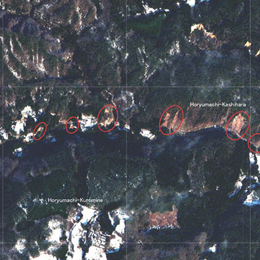
On 11 February 2023, the International Charter Space and Major Disasters received a request from the National Disaster Management Agency (NDMA) of Eswatini to provide satellite data in response to floods affecting the nation.
The Charter was activated in response, marking its 800th activation since November 2000.
As part of the activation, members of the Charter are mobilising their satellites to acquire data over the affected areas. The data are processed into maps by value adding teams to produce early estimates of flood extent and impact. The maps will provide NDMA and emergency services in Eswatini with valuable information to help in their efforts, offering them an overview of the situation they cannot obtain from the ground.
Weather-related disasters are the most common cause for a Charter activation, as they often result in floods as in Eswatini. The Charter responds to requests for other types of disaster every year, however, including the recent devastating earthquakes that affected Türkiye and Syria.
The floods in Eswatini are the second time the Charter has been activated for a disaster in the country, following Cyclone Eloise in 2021. Eswatini became an Authorised User of the Charter in 2019, as part of the Universal Access initiative. Authorised Users are organisations registered with the Charter to submit requests for satellite data in the event of a major disaster. They are typically national disaster management authorities or organisations acting on their behalf, and as the number of Authorised Users grows, the Charter is able to respond to requests for help in more countries
The Charter has been activated on average 42 times per year, though since 2020 it has been more than 50 per year. Its 800 activations have been in response to disasters in 131 countries and the Charter will continue to provide satellite data to support disaster response worldwide.

Related News