 English
 Spanish
 French
 Chinese
 Russian
 Portuguese
 Последняя Активация
Charter activations
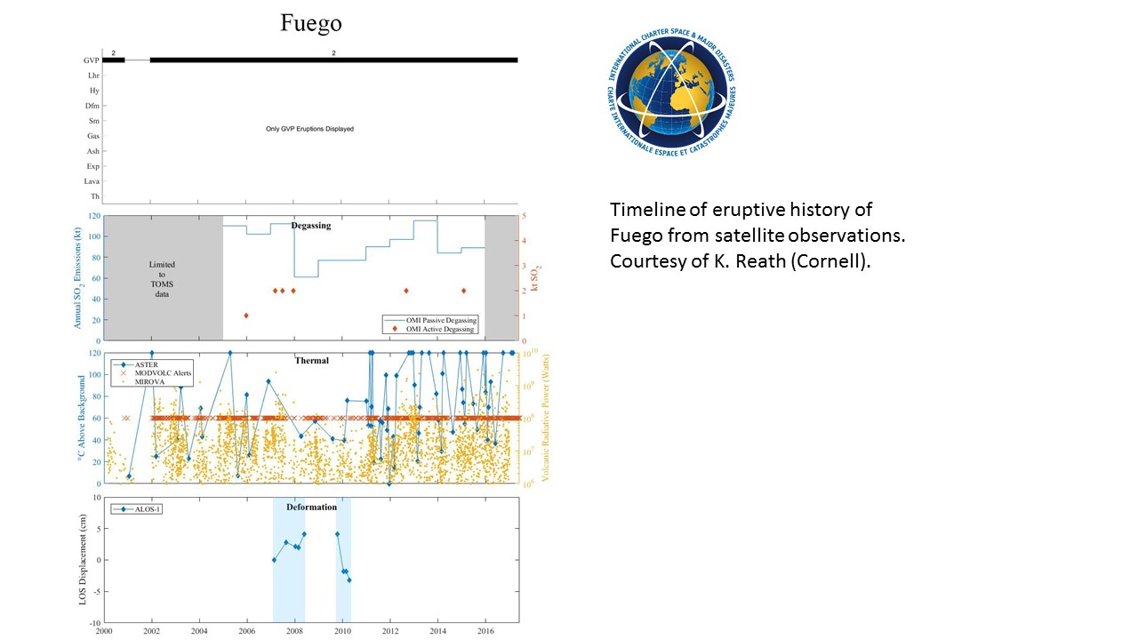
Fuego Volcano in Guatemala
Guatemala's Fuego volcano has erupted, covering villages in volcanic ash and debris during its most powerful eruption in over 100 years. Local reports confirm at least 69 people have been killed with many more still missing.
A state of emergency was declared as 3,000 people living near the volcano were evacuated to temporary shelters. The town of El Rodeo was worst affected, with rescuers still trying to reach the other nearby towns of Alotenango and San Miguel Los Lotes.
The eruption closed Guatemala's main international airport as columns of ash and smoke rose 10km into the air. The falling ash and rock has also covered the villages and coffee farms which sit on the slopes of the volcano.
Soldiers and firefighters assisting emergency workers are still searching for missing people in the dense covering of ash, mud and rock with at least 10 people being pulled from the lava flows by helicopter.
Related News and Resources
- Products published by Copernicus EMS
- The Copernicus EMS Monitors a Catastrophic Volcanic Eruption in Guatemala
- Guatemala volcano in pictures
- A Deadly Eruption Rocks Guatemala
- Video: GOES East Captures Fuego Volcano Eruption
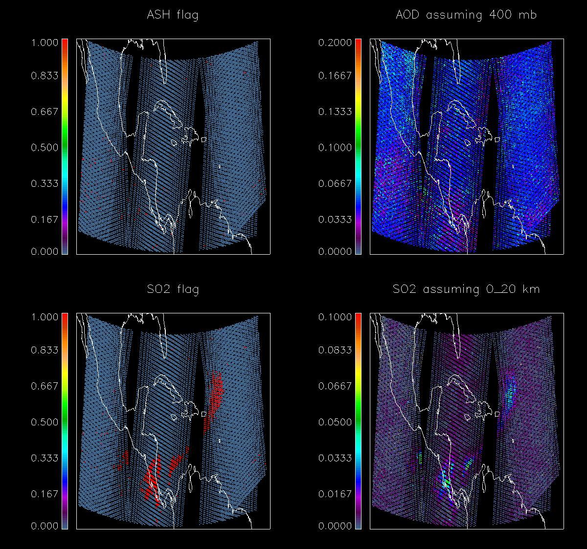
- Fuego Plume - Sentinel-5P satellite measures sulphur dioxide
- Heat Lingers from Fuego's Deadly Pyroclastic Debris Flows
| Тип события: | Volcano |
| Место события: | Guatemala |
| Date of Charter Activation: | 2018-06-05 |
| Время активации Хартии: | 09:12 |
| TЧасовой пояс в районе активации Хартии: | UTC+02:00 |
| Запрос на активацию поступил от: | CONRED |
| Номер активации: | 576 |
| Менеждер проекта от: | DLR |
Products
Fuego volcanic activity situation: Grading Map
Авторские права: Sentinel-2 © Contains modified Copernicus Sentinel data (2018)
Pleiades © CNES (2018) - Distribution: Airbus Defence and Space, all rights reserved
Map produced by Copernicus Emergency Management Service (2018 European Union)
Information about the Product
Получено: Sentinel-2: 15/01/2017
Pleiades: 09/06/2018
Источник: Sentinel-2 / Pleiades

Damage assessment at Estado de los puentes
Авторские права: WorldView-2 / 4 © DigitalGlobe Inc.
Map product by UNITAR / UNOSAT
Information about the Product
Получено: Worldview-2: 05/02/2018
Worldview-4: 06/06/2018
Источник: Worldview-2 / Worldview-4
Fuego volcanic activity situation, San Miguel Los Lotes
Авторские права: Pleiades © CNES (2018) - Distribution: Airbus Defence and Space, all rights reserved
Map produced by Copernicus Emergency Management Service (2018 European Union)
Information about the Product
Получено: Pleiades: 06/06/2018
Источник: Pleiades
Fuego volcanic activity situation, La Reunion
Авторские права: Pleiades © CNES (2018) - Distribution: Airbus Defence and Space, all rights reserved
Map produced by Copernicus Emergency Management Service (2018 European Union)
Information about the Product
Получено: Pleiades: 06/06/2018
Источник: Pleiades
Fuego Overview North: Delineation Map
Авторские права: Sentinel-2 © Contains modified Copernicus Sentinel data (2018)
Pleiades © CNES (2018) - Distribution: Airbus Defence and Space, all rights reserved
Map produced by Copernicus Emergency Management Service (2018 European Union)
Information about the Product
Получено: Sentinel-2: 15/01/2017
Pleiades: 09/06/2018
Источник: Sentinel-2 / Pleiades
Fuego Overview South: Delineation Map
Авторские права: Sentinel-2 © Contains modified Copernicus Sentinel data (2018)
Pleiades © CNES (2018) - Distribution: Airbus Defence and Space, all rights reserved
Map produced by Copernicus Emergency Management Service (2018 European Union)
Information about the Product
Получено: Sentinel-2: 15/01/2017
Pleiades: 09/06/2018
Источник: Sentinel-2 / Pleiades


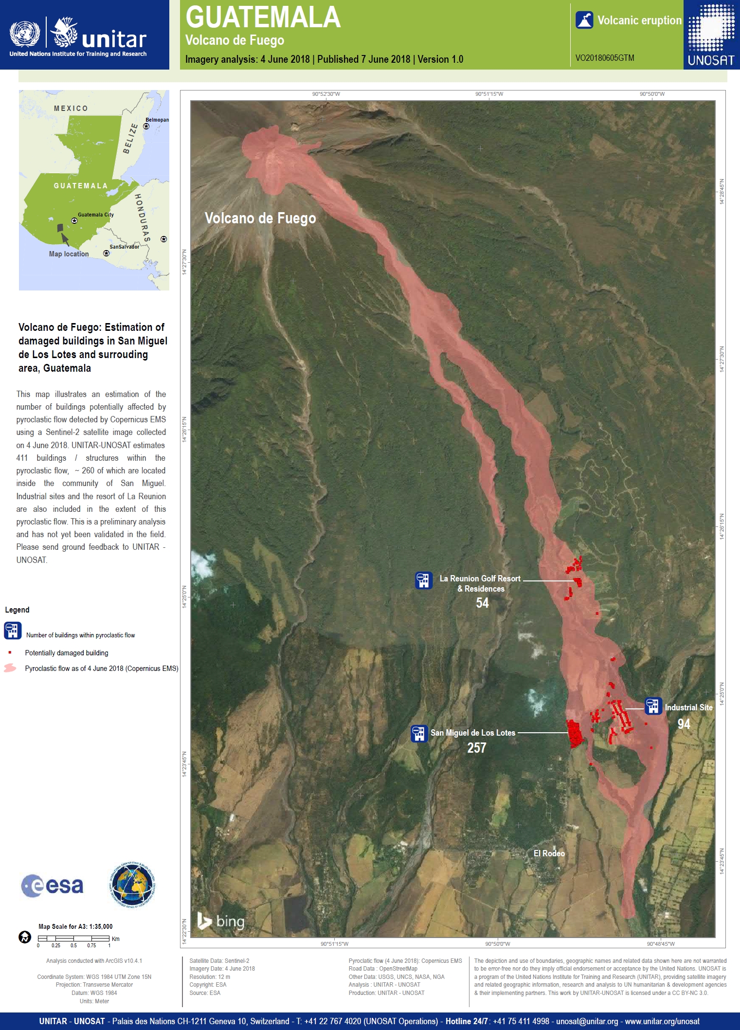
Estimation of damaged buildings in San Miguel de Los Lotes and surrounding area
Авторские права: Contains modified Copernicus Sentinel data (2018)
Map produced by UNITAR / UNOSAT
Information about the Product
Получено: 04/06/2018
Источник: Sentinel-2

 Вернуться к полному архиву активаций

