 English
 Spanish
 French
 Chinese
 Russian
 Portuguese
 Последняя Активация
Charter activations
Flood in Somalia
Weeks of heavy rainfall has resulted in extensive flooding in Somalia. The floods are estimated to have affected half a million people.
The rain caused the Shabelle and Juba rivers to bust their banks, and flood areas along the rivers. More than 200,000 people were forced to evacuate. The floods have affected HirShablle, Jubbaland and South West state. It has also been reported that Somali National security forces evacuated more than 10,000 people, marooned by the raging floods in Belet Weyne, in HirShabelle state.
Emergency settlements are being set up to tend to the victims, but there are concerns that limited access to clean water will pose a risk of water-borne diseases arising.
| Тип события: | Flood |
| Место события: | Somalia |
| Date of Charter Activation: | 2018-05-07 |
| Время активации Хартии: | 16:01 |
| TЧасовой пояс в районе активации Хартии: | UTC+02:00 |
| Запрос на активацию поступил от: | UNITAR-UNOSAT on behalf of United Nations Office for the Coordination of Humanitarian Affairs |
| Номер активации: | 570 |
| Менеждер проекта от: | UNITAR / UNOSAT |
Products

Situation report of flooding in Shebelle River, Southern Somalia
Авторские права: © CNES (2018) - Distribution: Airbus Defence and Space, all rights reserved
Download full report
Information about the Product
Получено: 15/05/2018
Источник: Pleiades
Situation report of flooding in Juba River, Southern Somalia
Авторские права: Pleiades © CNES (2018) - Distribution: Airbus Defence and Space, all rights reserved
Download full report
Information about the Product
Получено: 14/05/2018
Источник: Pleiades
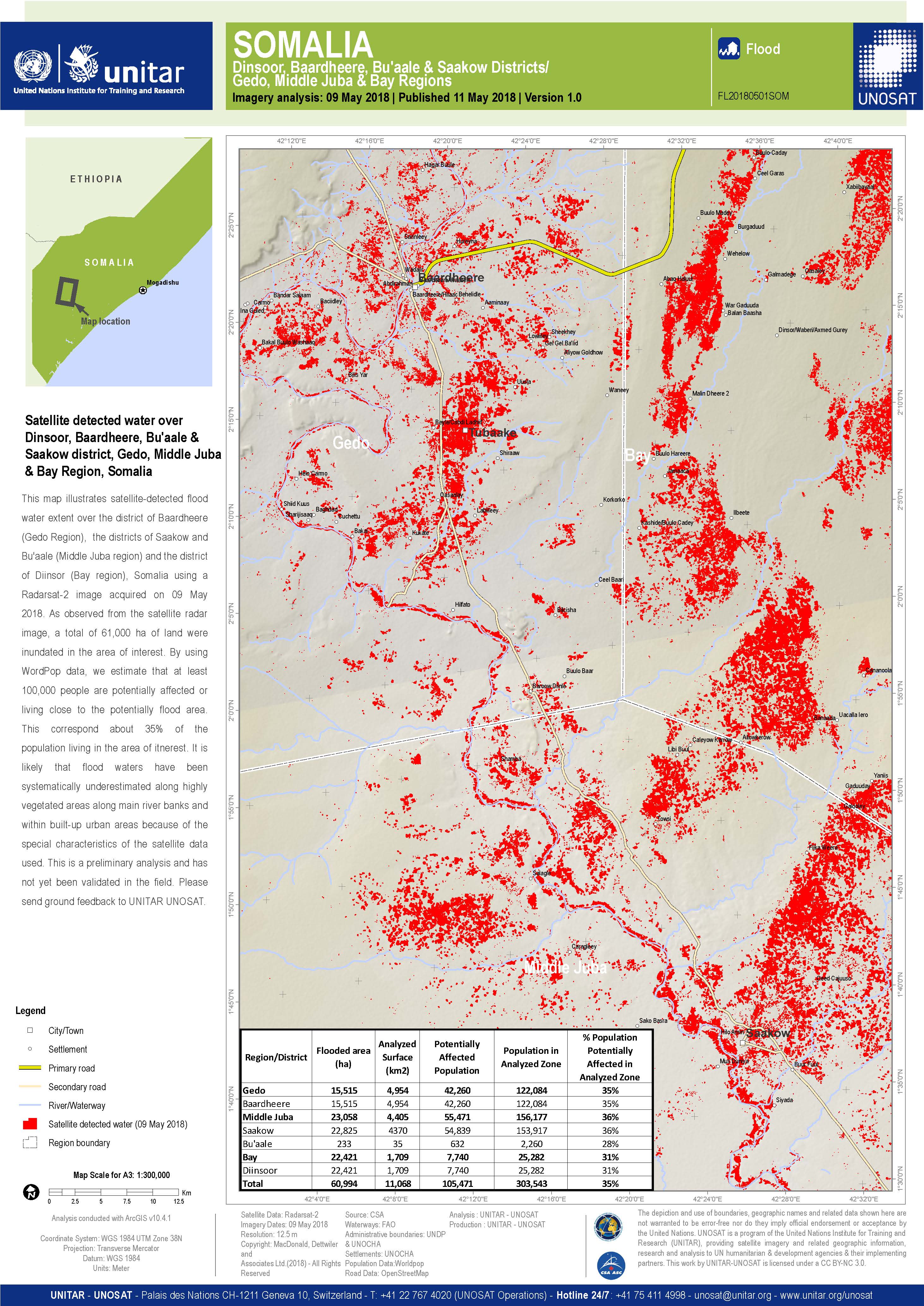
Flood detection in Dinsoor, Baardheere, Bu'aale, Saakow district, Gedo, Middle Juba and Bay Region, Somalia
Авторские права: RADARSAT-2 Data and Products © Maxar Technologies Ltd. (2018) - All Rights Reserved. RADARSAT is an official trademark of the Canadian Space Agency.
Map produced by UNITAR / UNOSAT
Information about the Product
Получено: 09/05/2018
Источник: RADARSAT-2
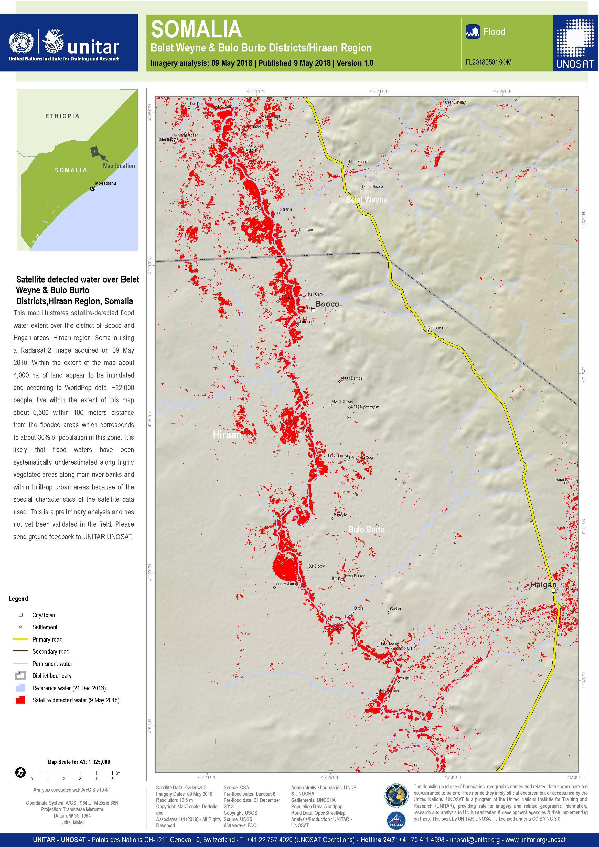
Flood detection in Belet Weyne and Bulo Burto Districts, Somalia
Авторские права: RADARSAT-2 Data and Products © Maxar Technologies Ltd. (2018) - All Rights Reserved. RADARSAT is an official trademark of the Canadian Space Agency.
Map produced by UNITAR / UNOSAT
Information about the Product
Получено: 09/05/2018
Источник: RADARSAT-2
 Вернуться к полному архиву активаций

