 English
 Spanish
 French
 Chinese
 Russian
 Portuguese
 Последняя Активация
Charter activations
Earthquake in Indonesia
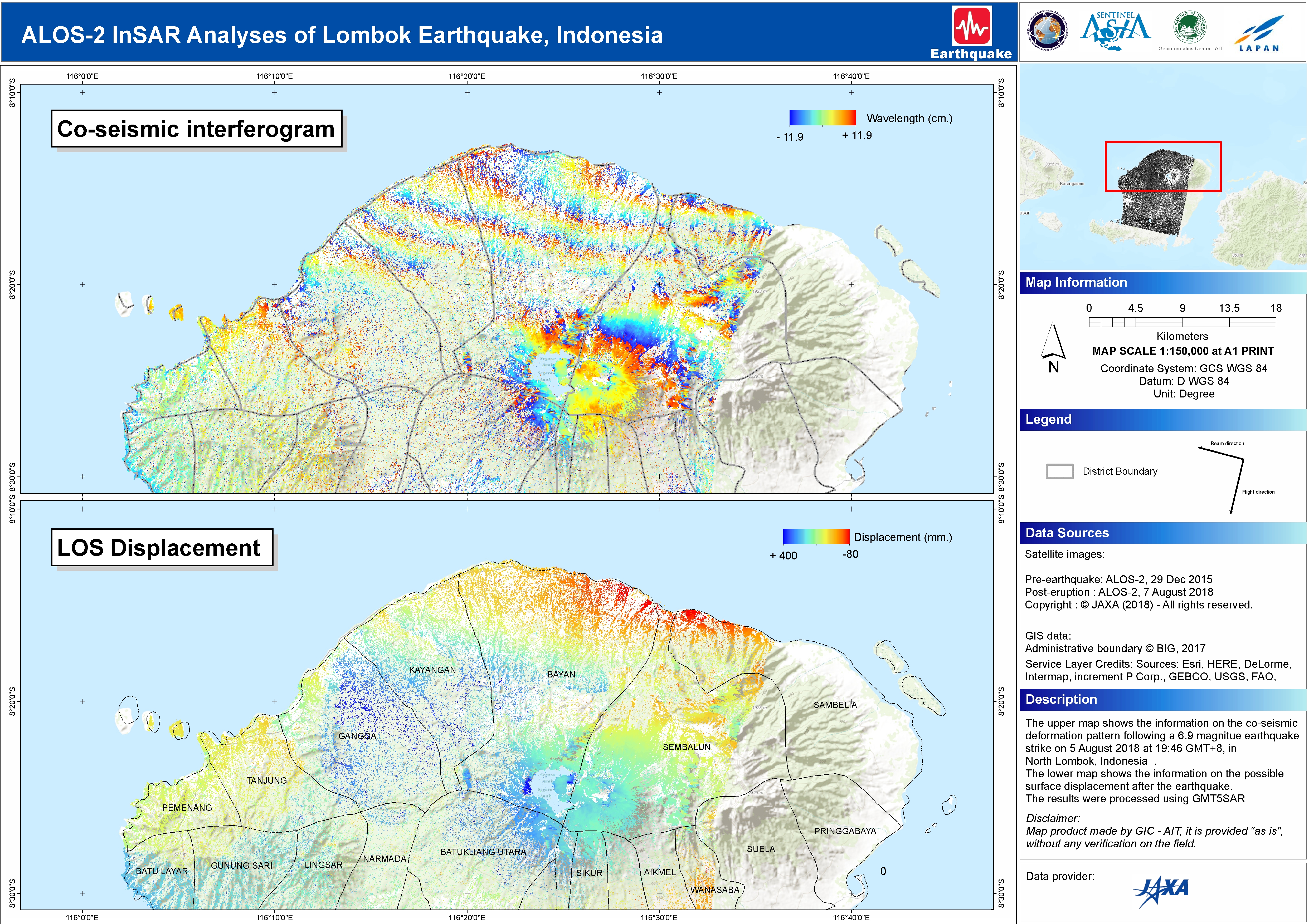
A magnitude 6.9 earthquake has struck the Indonesian island of Lombok. The neighbouring island of Bali was also affected. At least 91 people are reported to have been killed with many more injured.
The quake struck at a depth of 30 kilometres triggering tsunami warnings and the evacuation of thousands of people. 130 aftershocks have been recorded since the quake hit. This comes only a week after a smaller earthquake shook the island, killing 16 people.
Rescue officials reported most of the damage hit Lombok's main city of Mataram where thousands of buildings were damaged, causing widespread power cuts. Many tourists headed for the airport which was affected, but still operational. Others fled for the beach where boats evacuated people to safety.
Related News and Resources
| Место события: | Indonesia |
| Date of Charter Activation: | 2018-08-06 |
| Время активации Хартии: | 14:06 |
| TЧасовой пояс в районе активации Хартии: | UTC+09:00 |
| Запрос на активацию поступил от: | ADRC on behalf of LAPAN, Indonesia |
| Номер активации: | 580 |
| Менеждер проекта от: | AIT |
Products

Potentially affected settlements over Tanjung and Pemenang Districts, Indonesia
Download the full report
Авторские права: WorldView-2 © DigitalGlobe Inc.
Pleiades © CNES (2018), Distribution: Airbus DS
Map produced by UNITAR/UNOSAT
Information about the Product
Получено: WorldView-2: 11/07/2018 & 30/07/2018
Pleiades: 07/08/2018 & 08/08/2018
Источник: WorldView-2 / Pleiades
Earthquake damage grade assessment, South West Mataram, Indonesia
Авторские права: WorldView-2 © DigitalGlobe Inc.
Pleiades © CNES (2018), Distribution: Airbus DS
Copernicus Contributing Mission data. Map produced by the Copernicus Emergency Management Service
Information about the Product
Получено: WorldView-2: 03/06/2018
Pleiades: 07/08/2018
Источник: WorldView-2 / Pleiades
Earthquake damage grade assessment, North East Mataram, Indonesia
Авторские права: WorldView-2 © DigitalGlobe Inc.
Pleiades © CNES (2018), Distribution: Airbus DS
Copernicus Contributing Mission data. Map produced by the Copernicus Emergency Management Service
Information about the Product
Получено: WorldView-2: 03/06/2018
Pleiades: 07/08/2018
Источник: WorldView-2 / Pleiades

Potential Informal Gathering Sites over Tanjung & Pemenang Districts, Indonesia
Авторские права: WorldView-2 © DigitalGlobe Inc.
Pleiades © CNES (2018), Distribution: Airbus DS
Map produced by UNITAR/UNOSAT
Information about the Product
Получено: WorldView-2: 11/07/2018 & 30/07/2018
Pleiades: 07/08/2018 & 08/08/2018
Источник: WorldView-2 / Pleiades
Earthquake damage grade assessment, North West Mataram, Indonesia
Авторские права: WorldView-2 © DigitalGlobe Inc.
Pleiades © CNES (2018), Distribution: Airbus DS
Copernicus Contributing Mission data. Map produced by the Copernicus Emergency Management Service
Information about the Product
Получено: WorldView-2: 03/06/2018
Pleiades: 07/08/2018
Источник: WorldView-2 / Pleiades
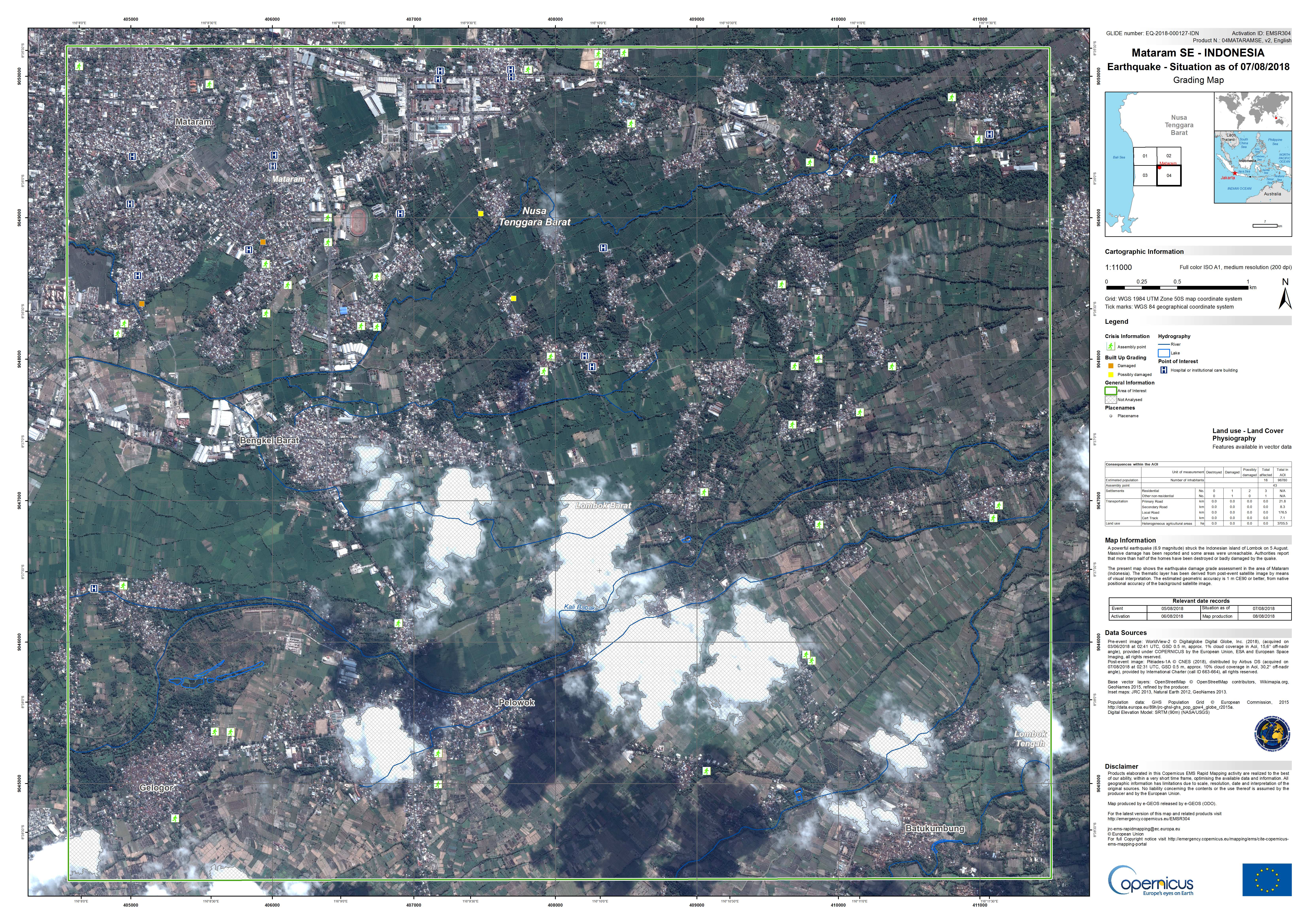
Earthquake damage grade assessment, South East Mataram, Indonesia
Авторские права: WorldView-2 © DigitalGlobe Inc.
Pleiades © CNES (2018), Distribution: Airbus DS
Copernicus Contributing Mission data. Map produced by the Copernicus Emergency Management Service
Information about the Product
Получено: WorldView-2: 03/06/2018
Pleiades: 07/08/2018
Источник: WorldView-2 / Pleiades
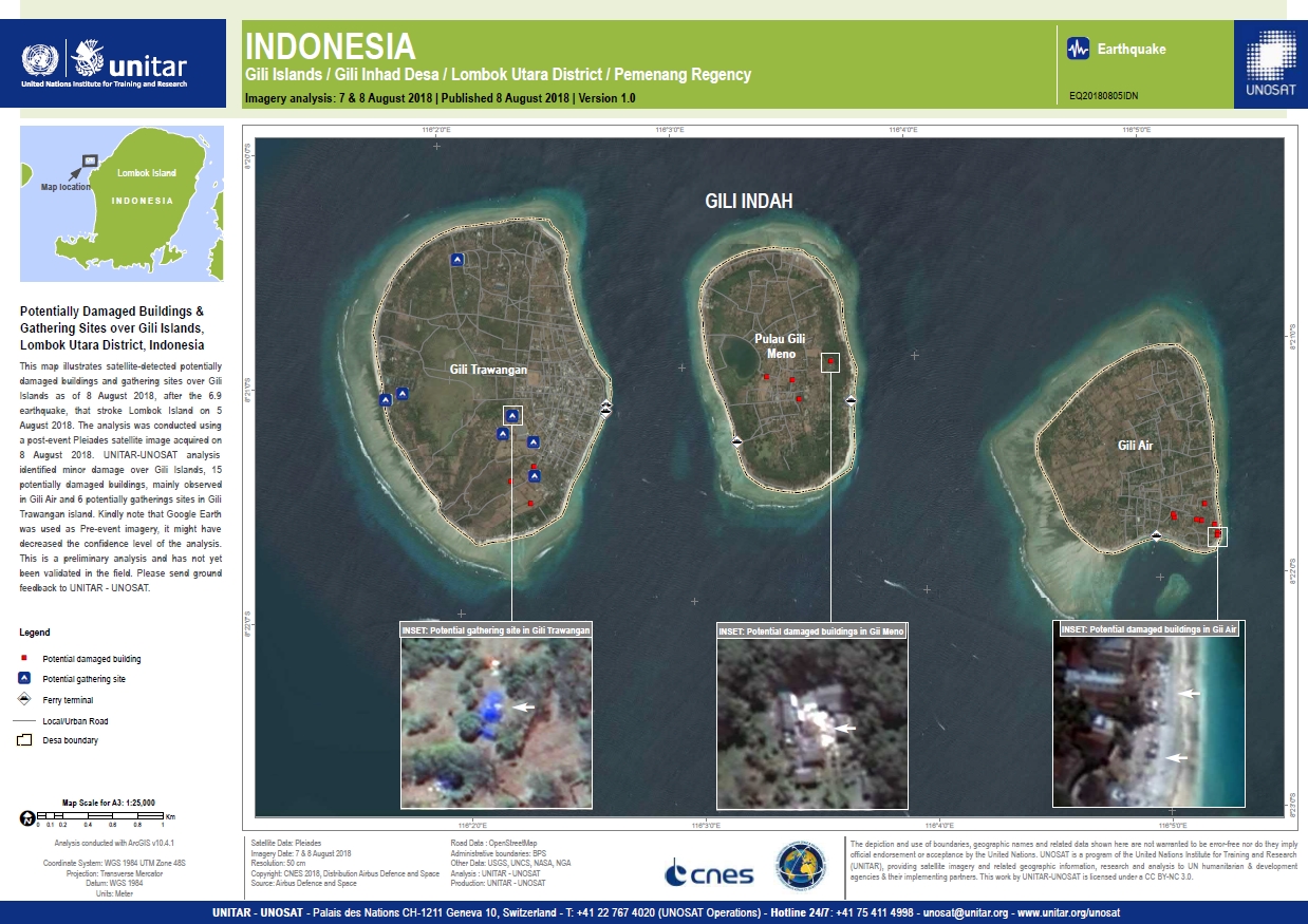
Potentially Damaged Buildings & Gathering Sites over Gili Islands, Lombok Utara District, Indonesia
Авторские права: Pleiades © CNES (2018), Distribution: Airbus DS
Map produced by UNITAR/UNOSAT
Information about the Product
Получено: 07/08/2018 & 08/08/2018
Источник: Pleiades
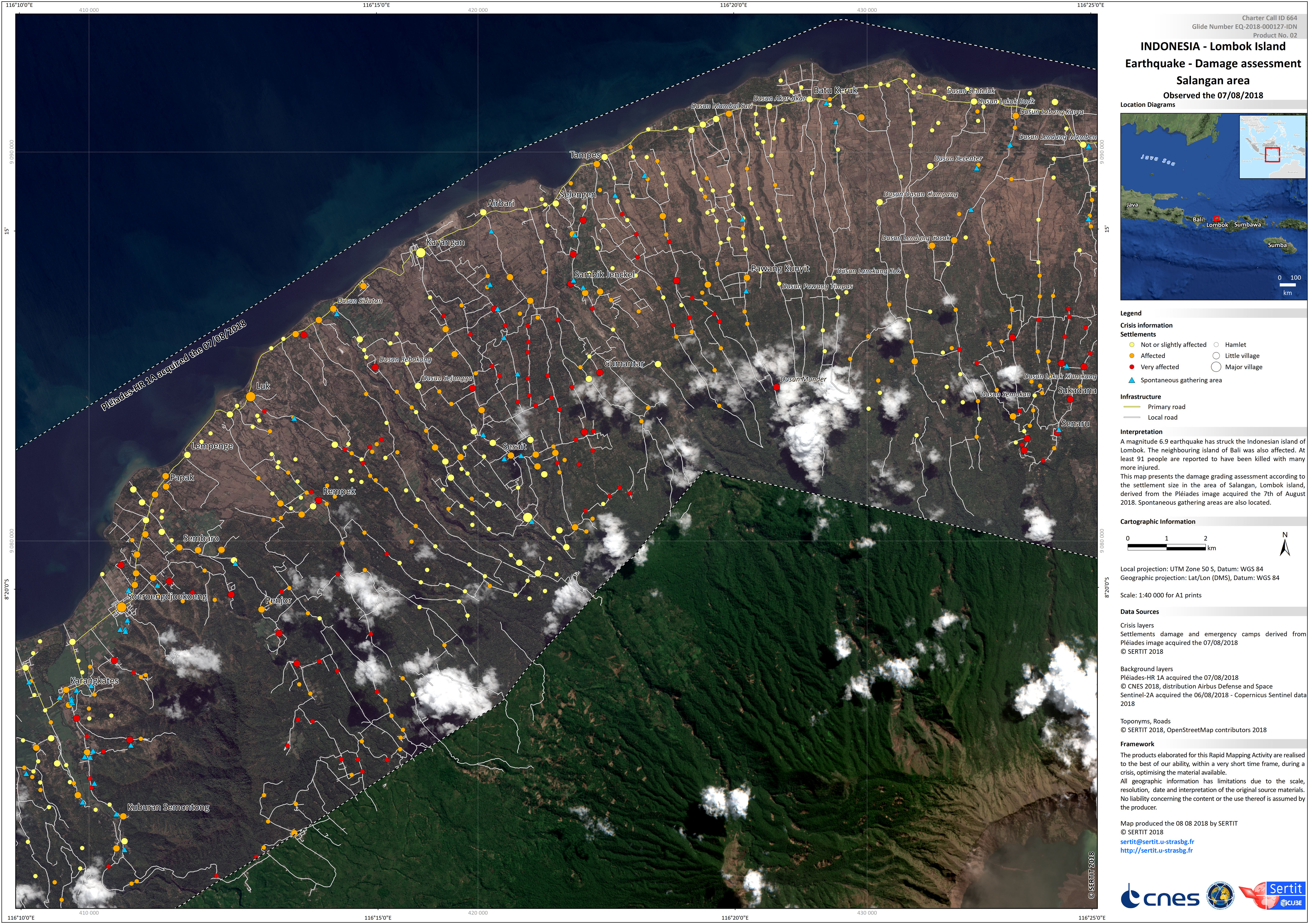
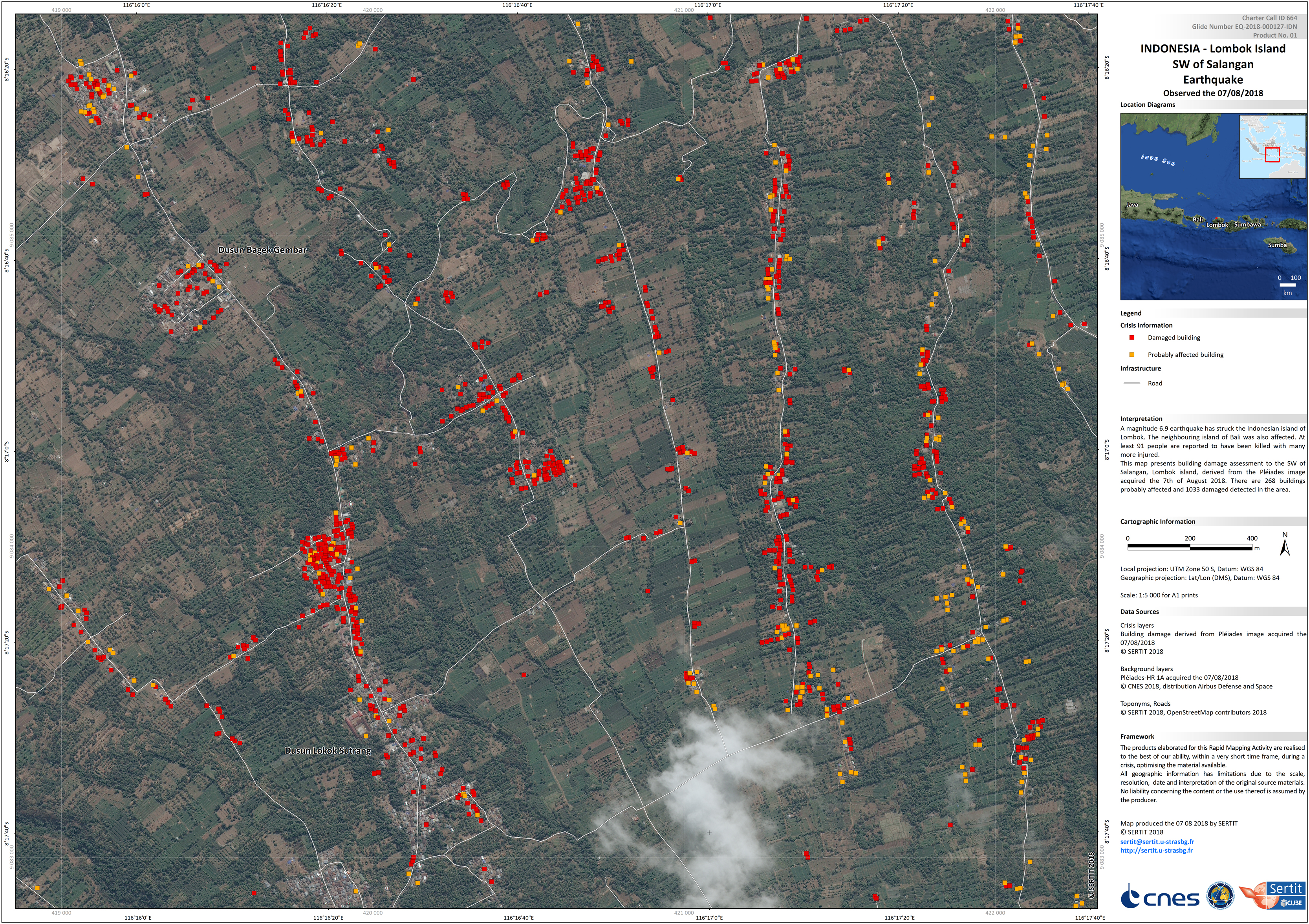
Damage assessment of Salangan, Lombok Island, Indonesia
Авторские права: Pleiades © CNES (2018), Distribution: Airbus DS
Sentinel-2 © Copernicus Sentinel data (2018)
Map produced by SERTIT
Information about the Product
Получено: Pleiades: 07/08/2018
Sentinel-2: 06/08/2018
Источник: Pleiades / Sentinel-2
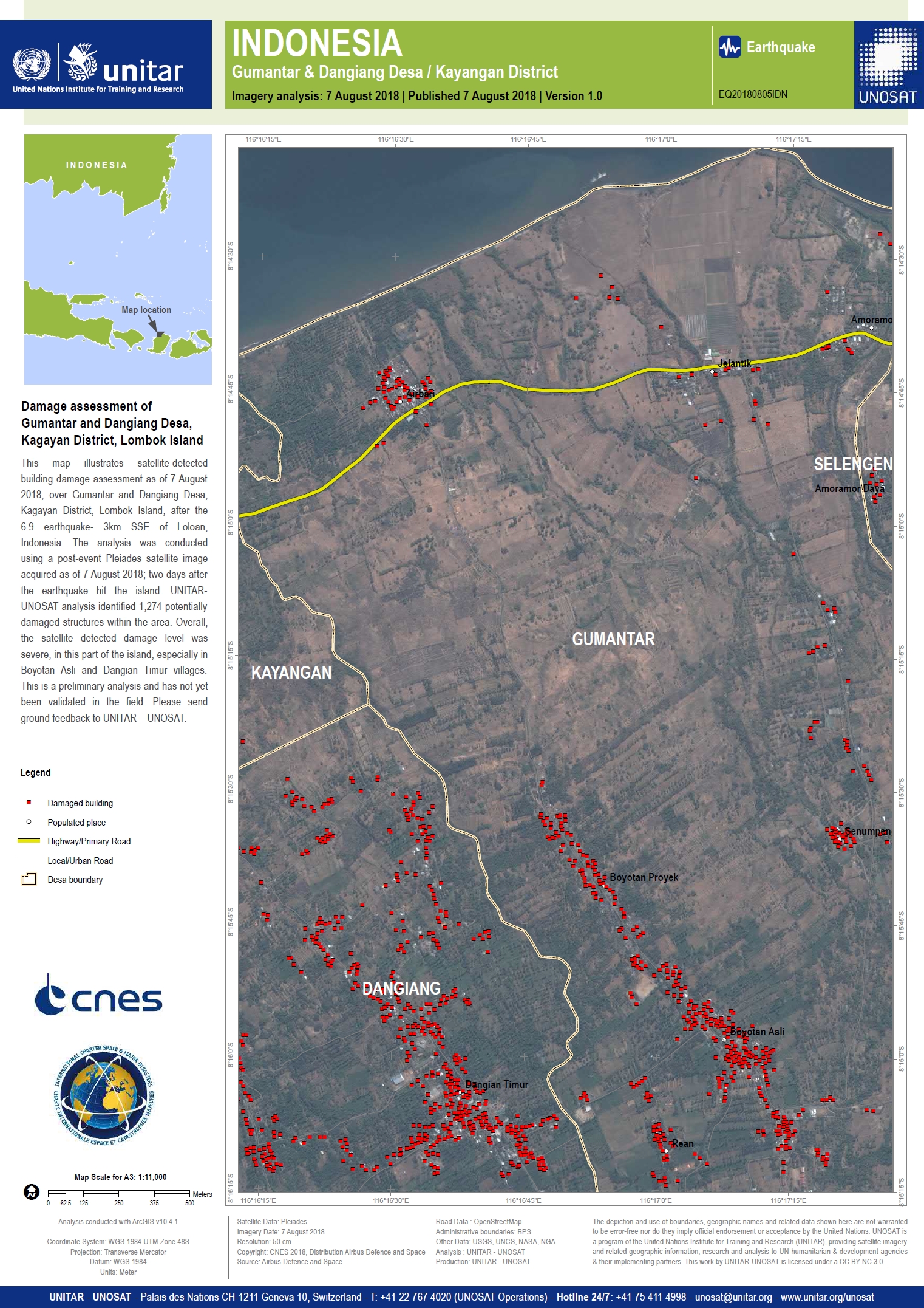
Damage assessment of Gumantar and Dangiang Desa, Kagayan District, Lombok Island, Indonesia
Авторские права: Pleiades © CNES (2018), Distribution: Airbus DS
Map produced by UNITAR/UNOSAT
Information about the Product
Получено: 07/08/2018
Источник: Pleiades
 Вернуться к полному архиву активаций

