Charter activations
Landslide in Karnataka State, India
Persistent heavy rainfall since 14 August has caused severe flooding and landslides across the districts of Karnataka. The worst affected areas are Somawarpet, Suntikoppa, Mukkodlu, Madapur, Harangi, Siddapur.
Discharges from dams including Mettur, has led to multiple villages and fields of crops being inundated along the banks of Cauvery and its tributary Bhavani. Almost 14,000 people have been displaced and moved to safe camps around the state.
The Chief Minister's Office reported the landslides and heavy rain have claimed six lives in the district since 16 August. According to the Karnataka State Natural Disaster Monitoring Centre, the district has received rainfall of up to 25.3cm and an average rainfall of 11.9 cm over the past 24 hours.
Local media have also reported that hundreds of people remain stranded on various hills of the district. Telecoms infrastructure is being restored as a priority. A number of boats and military relief forces are assisting in rescues across the area.
| Type of Event: | Landslide |
| Location of Event: | India |
| Date of Charter Activation: | 2018-08-21 |
| Time of Charter Activation: | 14:34 |
| Time zone of Charter Activation: | UTC+05:30 |
| Charter Requestor: | ISRO |
| Activation ID: | 584 |
| Project Management: | National Remote Sensing Centre |
Products

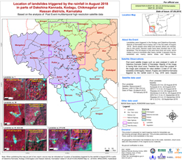
Location of landslides in Karnataka State, India
Copyright: ResourceSat-2 data and products © ISRO (2018) - All rights reserved
Pleiades © CNES (2018), Distribution: Airbus DS
KOMPSAT © KARI 2018
SPOT-7 and SPOT-6 © Airbus DS (2018)
WorldView-2 © DigitalGlobe Inc.
Gaofen-2 © CNSA 2018
Map produced by NRSC/ISRO
Information about the Product
Acquired: ResourceSat-2: 03/03/2018
Pleiades: 22/08/2018, 25/08/2018 and 01/09/2018
KOMPSAT: 22/08/2018
SPOT-7: 23/08/2018
WorldView-2: 25/08/2018
SPOT-6: 01/09/2018
Gaofen-2: 02/09/2018
Source: ResourceSat-2 / Pleiades / KOMPSAT / SPOT-7 / WorldView-2 / SPOT-6 / Gaofen-2 (GF-2)

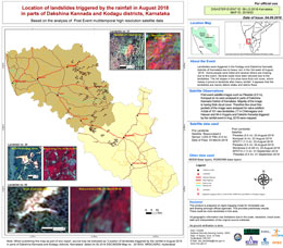
Location of landslides in Dakshina Kannada and Kodagu Districts of Karnataka State, India
Copyright: ResourceSat-2 data and products © ISRO (2018) - All rights reserved
Pleiades © CNES (2018), Distribution: Airbus DS
KOMPSAT © KARI 2018
SPOT-7 and SPOT-6 © Airbus DS (2018)
WorldView-2 © DigitalGlobe Inc.
Map produced by NRSC/ISRO
Information about the Product
Acquired: ResourceSat-2: 03/03/2018
Pleiades: 22/08/2018, 25/08/2018 and 01/09/2018
KOMPSAT: 22/08/2018
SPOT-7: 23/08/2018
WorldView-2: 25/08/2018
SPOT-6: 01/09/2018
Source: ResourceSat-2 / Pleiades / KOMPSAT / SPOT-7 / WorldView-2 / SPOT-6

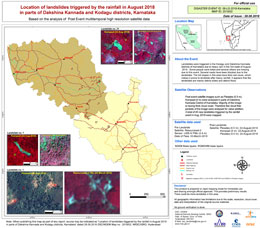
Location of landslides in Dakshina Kannada and Kodagu Districts of Karnataka State, India
Copyright: ResourceSat-2 data and products © ISRO (2018) - All rights reserved
Pleiades © CNES (2018), Distribution: Airbus DS
KOMPSAT © KARI 2018
Map produced by NRSC/ISRO
Information about the Product
Acquired: ResourceSat-2: 03/03/2018
Pleiades: 22/08/2018 and 25/08/2018
KOMPSAT: 22/08/2018
Source: ResourceSat-2 / Pleiades / KOMPSAT

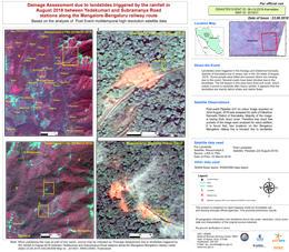
Landslide Damage Assessment, Karnataka, India
Copyright: ResourceSat-2 data and products © ISRO (2018) - All rights reserved
Pleiades © CNES (2018), Distribution: Airbus DS
Map produced by NRSC/ISRO
Information about the Product
Acquired: ResourceSat-2: 03/03/2018
Pleiades: 22/08/2018
Source: ResourceSat-2 / Pleiades
 Back to the full activation archive

 English
 Spanish
 French
 Chinese
 Russian
 Portuguese


