 English
 Spanish
 French
 Chinese
 Russian
 Portuguese
 最新宪章启动
Charter activations
Semeru volcano in Indonesia
Semeru volcano in Indonesia erupted, spewing a cloud of ash 15 km high and forcing the evacuation of nearly 2,000 people.
Indonesia's Center for Volcanology and Geological Hazard Mitigation, PVMBG, raised the level of volcanic activity to its highest level and warned residents not to approach within five miles (8km) of the volcano.
With 142 volcanoes, Indonesia is home to 8.6 million people living within 10 km (six miles) of one – the world's largest population living in close range of a volcano.
Related News and Resources
| 事件类型: | Volcano |
| 事件地点: | Indonesia |
| 启动宪章的日期: | 2022-12-05 |
| 宪章启动时间: | 11:17 |
| 宪章启动时区: | UTC+09:00 |
| 宪章要求者: | ADRC on behalf of Japan International Cooperation Agency (JICA) |
| 启动ID: | 792 |
| 项目经理: | ChathumalMadhuranga WeththasingheArachchige (Asian Institute of Technology) |
| act-value-adders: | Angsana Chaksan (Asian Institute of Technology (AIT)) Julie Griswold (USGS) |
Products

Potentially affected areas by pyroclastic flow/deposits after the Mount Semeru volcanic eruption in East Java.
版权: WorldView © (2022) DigitalGlobe, Inc., Longmont CO USA 80503. DigitalGlobe and the DigitalGlobe logos are trademarks of DigitalGlobe, Inc. The use and/or dissemination of this data and/or of any product in any way derived there from are restricted. Unauthorized use and/or dissemination is prohibited
VRSS-2 © ABAE (2022)
SPOT-6 includes material © AIRBUS DS (2022)
Contains modified Copernicus Sentinel data (2022)
Map produced by UNITAR/UNOSAT
Information about the Product
已获得: WorldView-2: 04/05/2022
VRSS-2: 08/12/2022
SPOT-6: 12/12/2022
Sentinel-2: 17/09/2022
WorldView-3: 09/12/2022
源: WorldView-2 / VRSS-2 / SPOT-6 / Sentinel-2 / WorldView-3
类别: Grading Map
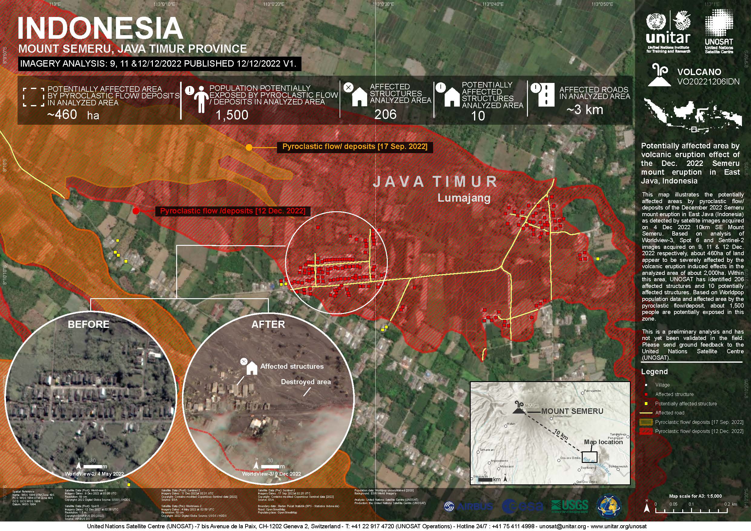
Potentially affected area by Mount Semeru volcanic eruption in East Java, Indonesia
版权: Contains modified Copernicus Sentinel data (2022)
WorldView © (2022) DigitalGlobe, Inc., Longmont CO USA 80503. DigitalGlobe and the DigitalGlobe logos are trademarks of DigitalGlobe, Inc. The use and/or dissemination of this data and/or of any product in any way derived there from are restricted. Unauthorized use and/or dissemination is prohibited
SPOT-6 includes material © AIRBUS DS (2022)
Map produced by UNITAR/UNOSAT
Information about the Product
已获得: Sentinel-2: 17/09/2022, 11/12/2022
WorldView-2: 04/05/2022
WorldView-3: 09/12/2022
SPOT-6: 12/12/2022
源: Sentinel-2 / WorldView-2 / WorldView-3 / SPOT-6
类别: Reference Map

Preliminary satellite derived damage assessment, Mount Semeru, Volcanic eruption, East Java province, Indonesia
Download full report
版权: TerraSAR-X © DLR e.V. (2022), Distribution Airbus DS Geo GmbH
PlanetScope © Planet Labs Inc. (2022)
Contains modified Copernicus Sentinel data (2022)
Report prepared by UNITAR / UNOSAT
Information about the Product
已获得: TerraSAR-X: 05/12/2022
PlanetScope: 04/12/2022, 05/12/2022
Sentinel-2: 06/12/2022
源: TerraSAR-X / PlanetScope / Sentinel-2
类别: Delineation Map

 返回完整的响应档案

