 English
 Spanish
 French
 Chinese
 Russian
 Portuguese
 Earthquake in Indonesia
Earthquake in Indonesia
Charter activations
Earthquake in Indonesia
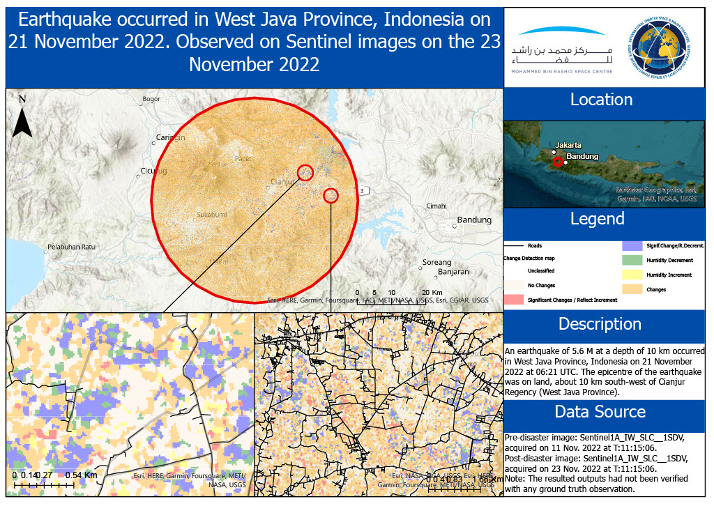
A 5.6 magnitude earthquake struck the main Indonesian island of Java on November 21 2022 killing scores of people and injuring hundreds, officials reported.
The quake struck Cianjur town in West Java, at a shallow depth of 10km (6 miles) and the tremor was felt in the capital Jakarta about 100km away according to US Geological Survey data. People were taken to hospital with many being treated in a hospital car park after the hospital was left without power for several hours . Rescuers worked hard to try to save others thought to still be trapped under collapsed buildings.
The area where the quake struck is densely populated and prone to landslides, with poorly built houses reduced to rubble in many areas.
Earthquakes are common in Indonesia, which sits on the "ring of fire" area of tectonic activity in the Pacific.
Related News and Resources
| Location of Event: | Indonesia |
| Date of Charter Activation: | 2022-11-22 |
| Time of Charter Activation: | 12:54 |
| Time zone of Charter Activation: | UTC+09:00 |
| Charter Requestor: | ADRC on behalf of Badan Riset dan Inovasi Nasional (BRIN, Indonesia) UNITAR on behalf of International Federation of Red Cross and Red Crescent Societies (IFRC) |
| Activation ID: | 791 |
| Project Management: | Jakrapong Tawala (UNITAR) |
| act-value-adders: | Copernicus EMS Alia Almekhyat (Mohammed Bin Rashid Space Centre (MBRSC)) |
| Activation handled in collaboration with Copernicus Emergency Management Service |
Products


Preliminary Satellite-derived Damage Assessment Indonesia Earthquake
Download full report
Copyright: Includes Pleiades material © CNES (2022), Distribution Airbus DS.
Report produced by UNITAR / UNOSAT
Information about the Product
Acquired: 23/11/2022
Source: Pleiades
Category: Dossier
 Back to the full activation archive
