 English
 Spanish
 French
 Chinese
 Russian
 Portuguese
 Dernière activation
Charter activations
Earthquake in Philippines
A 6.5 magnitude earthquake struck the Tulunan area of Cotabato province on the southern island of Mindanao, Philippines.
The National Disaster Risk Reduction and Management Council (NDRRMC) reported that 14 people have been killed and 403 injured. They also stated 12,000 people were sheltering in 19 evacuation centres, and over 2,000 houses have been totally or partly damaged.
This is the third earthquake to affect the area after a 6.6 magnitude quake shook the area only days before. On 16 October an earthquake with a magnitude 6.3 killed at least seven people, injured more than 200 and destroyed or damaged more than 7,000 buildings.
Several cities and towns in the quake-hit areas have closed schools and advised people not to work in office buildings as more tremors are possible.
According to the Pacific Tsunami Warning Centre, there was no tsunami threat with the quake.
| Location of Event: | Philippines |
| Date of Charter Activation: | 2019-11-01 |
| Time of Charter Activation: | 14:37 |
| Time zone of Charter Activation: | UTC+09:00 |
| Charter Requestor: | Asian Disaster Reduction Center ADRC |
| Activation ID: | 629 |
| Project Management: | Philippine Institute Of Volcanology and Seismology |
Products
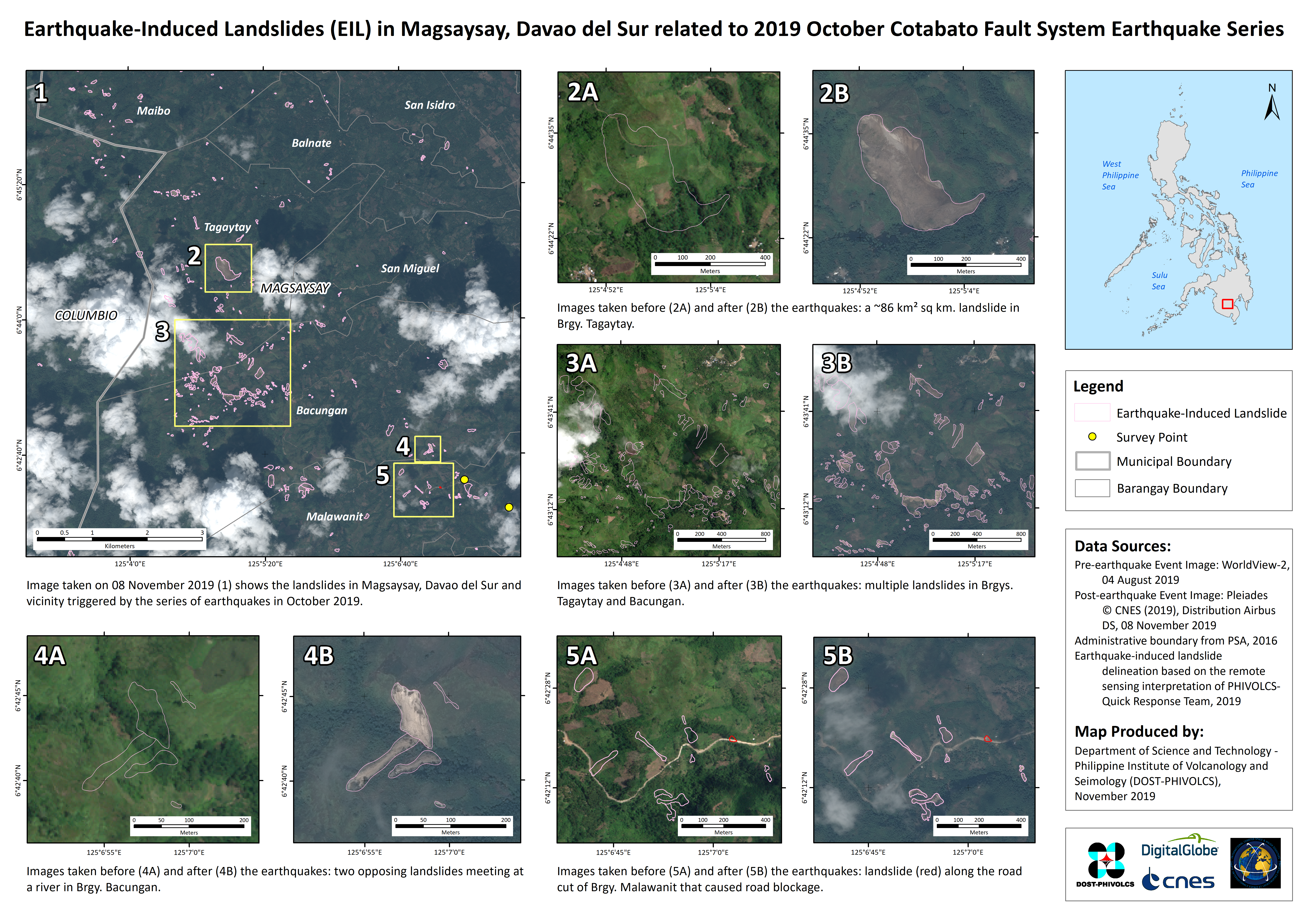
Landslides caused by the earthquake at Magsaysay in Davao del Sur, the Philippines
Copyright: WorldView-2 © DigitalGlobe Inc.
Pleiades © CNES (2019) - Distribution: Airbus Defence and Space, all rights reserved
Map produced by DOST-PHIVOLCS
Information about the Product
Acquired: WorldView-2: 04/08/2019
Pleiades: 08/11/2019
Source: WorldView-2 / Pleiades
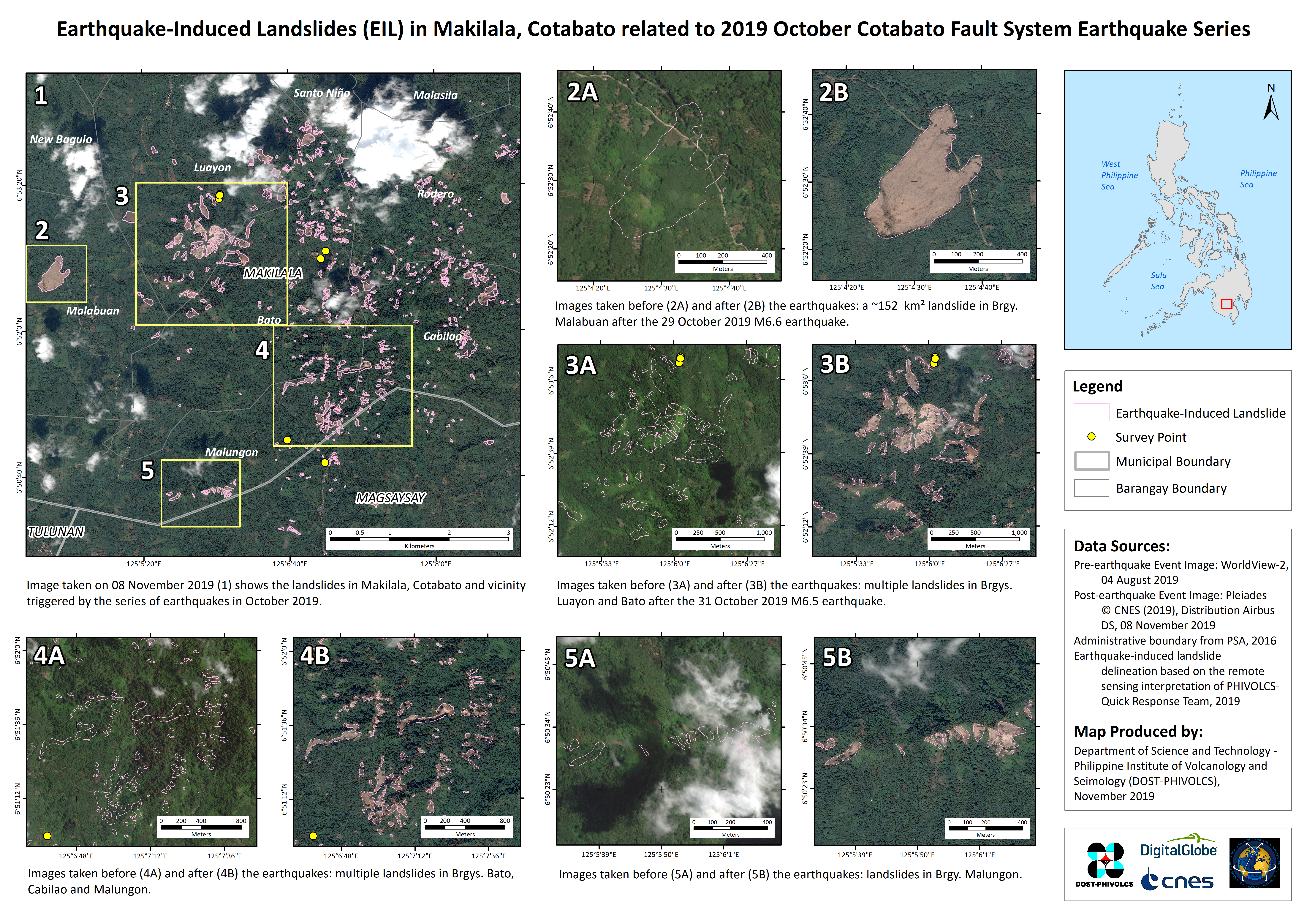
Landslides caused by the earthquake at Makilala in Cotabato, the Philippines
Copyright: WorldView-2 © DigitalGlobe Inc.
Pleiades © CNES (2019) - Distribution: Airbus Defence and Space, all rights reserved
Map produced by DOST-PHIVOLCS
Information about the Product
Acquired: WorldView-2: 04/08/2019
Pleiades: 08/11/2019
Source: WorldView-2 / Pleiades
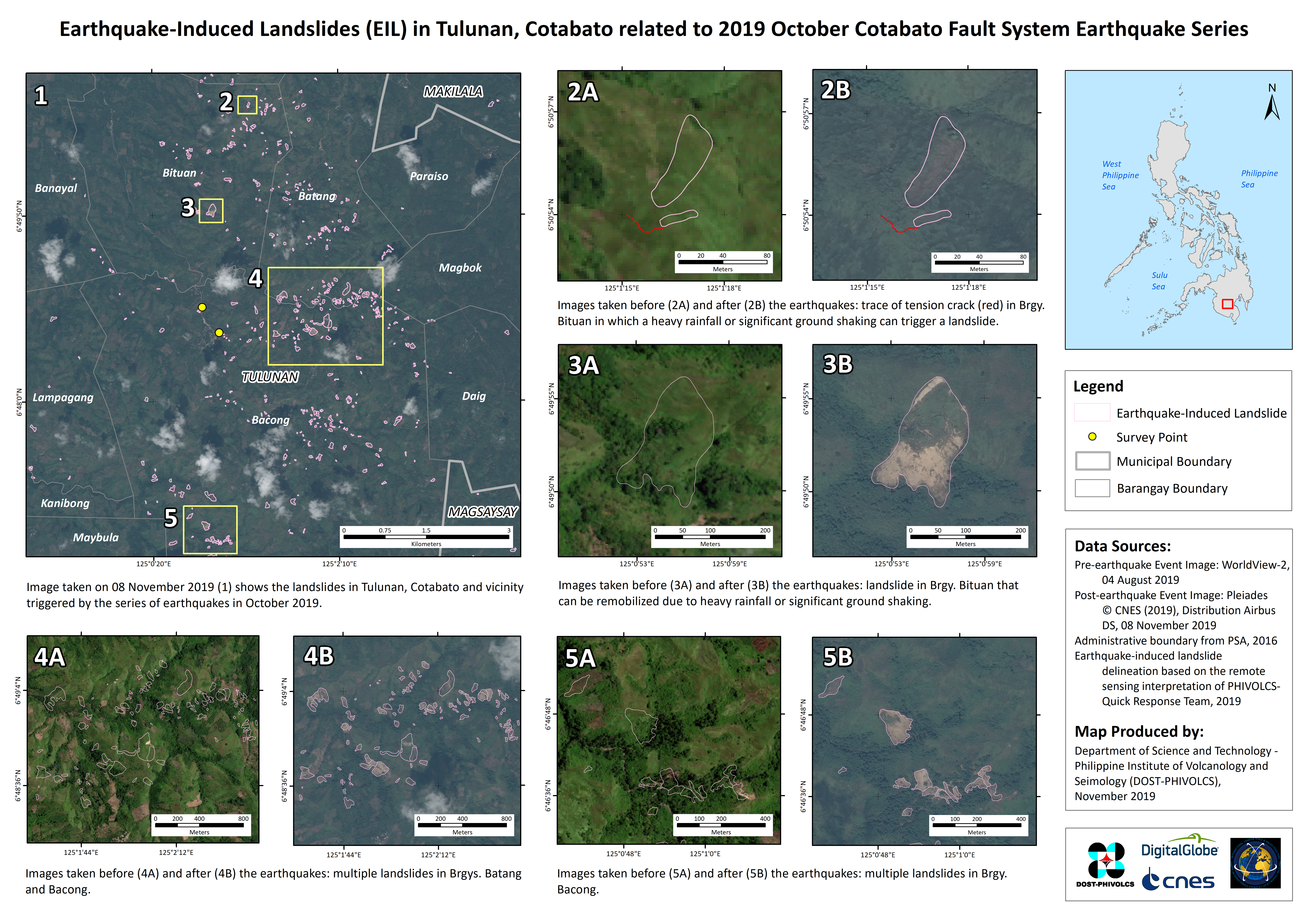
Landslides caused by the earthquakes at Tulanan, in Cotabato, the Philippines
Copyright: WorldView-2 © DigitalGlobe Inc.
Pleiades © CNES (2019) - Distribution: Airbus Defence and Space, all rights reserved
Map produced by DOST-PHIVOLCS
Information about the Product
Acquired: WorldView-2: 04/08/2019
Pleiades: 08/11/2019
Source: WorldView-2 / Pleiades


 Back to the full activation archive

