English
 Spanish
 French
 Chinese
 Russian
 Portuguese
A new system based on advanced IT technologies to better support Charter operations
News
06 octobre 2021
A new system based on advanced IT technologies to better support Charter operations
The International Charter ‘Space and Major Disasters' is an international agreement among space agencies to support the immediate disaster response phase with satellite data and information. This is organized with Charter activations that are triggered by Authorized Users. Since its inception in 2000, it has supported 723 activations in 129 countries worldwide.
In support to the International Charter, a tool, performing workflow and information management, is used during the operational process of activations. Custom implemented and maintained by ESA since 2010, the "Charter Operations System 2nd generation" (COS-2) provides accurate information about Charter activations. COS-2 is dedicated to Charter members and partners, providing a dedicated interface according to the operational role of the user, from the entering of the activation request up to the preparation of the final report. In particular, it helps the Charter Project Manager (PM) to order, make a preliminary assessment of the satellite images (based on preview images) and deliver Earth Observation (EO) data in the disaster response phase. It provides dashboards to monitor activations and displays metadata, quick looks and footprints of the EO data. COS-2 has been made available for operations starting at the beginning of 2015 and since then it has been used to support all of the Charter activations.
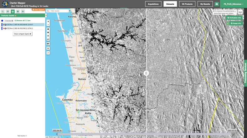
To better support Charter PMs and Value Adders (VA) in the context of activations, COS-2 has been augmented with a processing environment, i.e., a suite of on-line EO-based services that is called the ESA Charter Mapper. It is able to access and display EO data, perform visual analysis, apply GIS functionalities and to perform EO-based processing to extract geo-information from imagery.
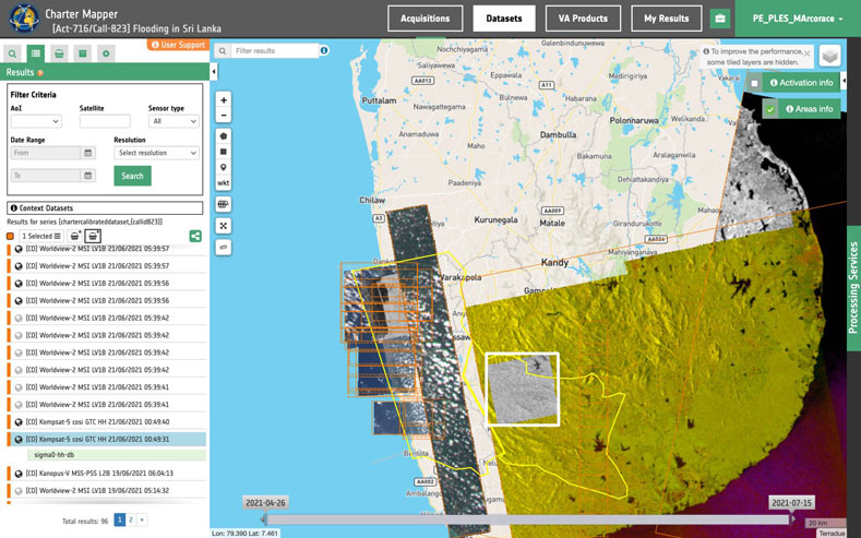
Since August 2021, the ESA Charter Mapper is available to support operations. It is intended to ease access and use of the EO data during an activation. EO data received from the Charter members and partners through COS-2 are automatically ingested and transformed as full-resolution browse EO images. The PMs and VAs can browse imagery, filter and select the EO data of interest, analyze and process them online with EO-based services and toolboxes. They can use the ESA Charter Mapper to create ad-hoc composites of different spectral bands to optimize the signal to the type of hazards and to observe changes across time as the activation develops.
Automated processing executed in the background whenever new EO data is provided, allows PMs and VAs to immediately operate pre-processed data, reducing their workload. However, the generation of information products (Value-Added Products) requires supervision from experts and remains the responsibility of the VAs and PMs.
The idea of an on-line processing environment finds its origin in 2017. The Charter started a reflection about a complete on-line processing environment that would ease access and use of EO data during Charter operations, considering also the strong increase of EO data provided for each activation (often hundreds of images) by the Charter member agencies. Back in 2017, ESA proposed a prototype of a Processing Environment with basic online services, like the visualization and screening of full-resolution EO data. Based on ESA's proposition, the Charter defined the guidelines for exploiting such capability and all the procedures required from testing to operations. Other Charter members are also taking the initiative and are proposing other Processing Environments.
For further information about the ESA Charter Mapper please consult the Frequently Asked Questions.

Related News