最小化 最新宪章启动

Charter activations

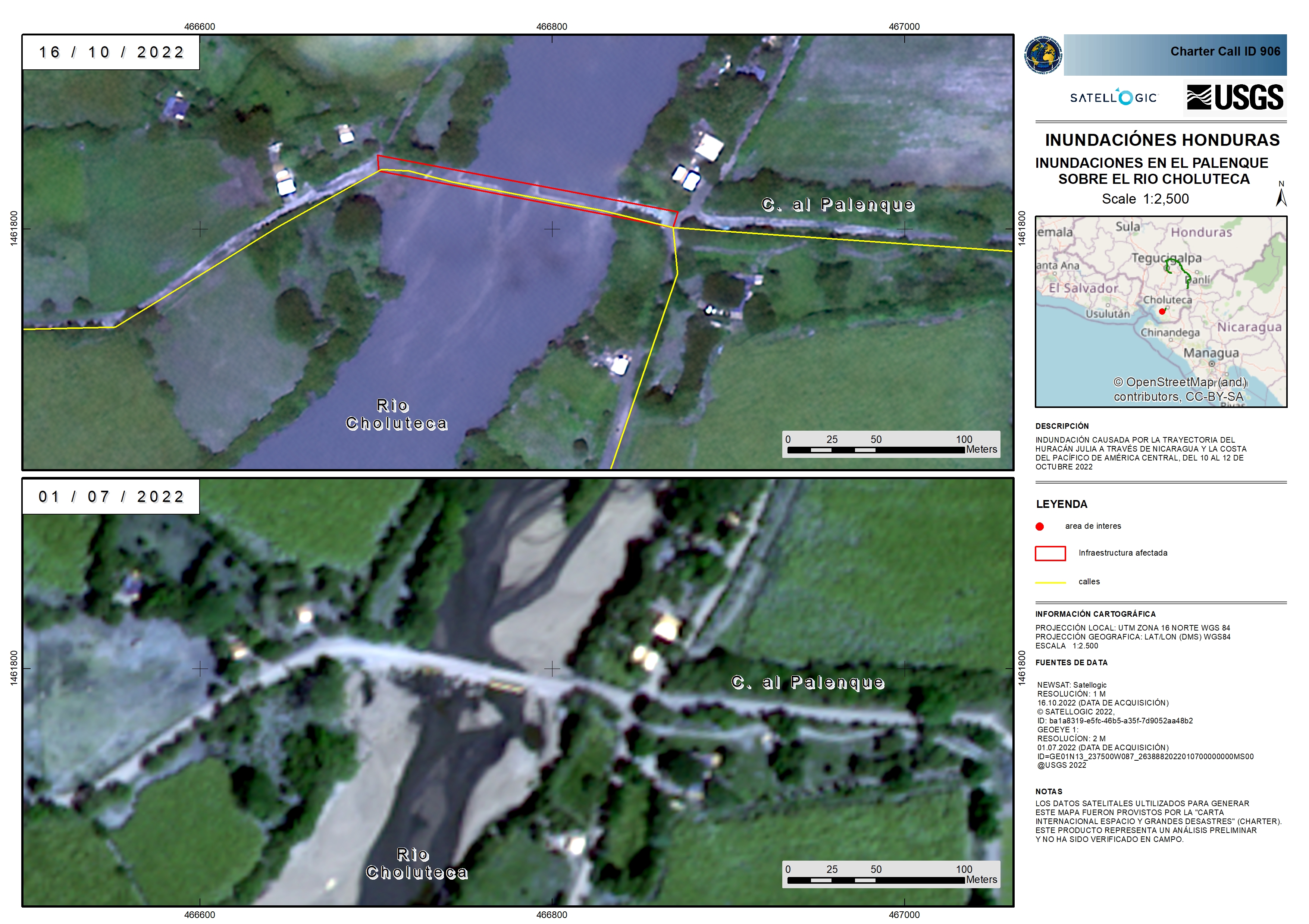
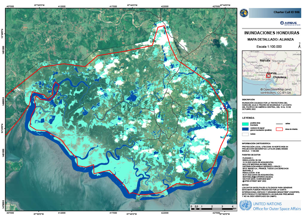
Hurricane Julia in Honduras

Hurricane Julia was a deadly tropical cyclone that caused significant impacts in Central America as a Category 1 hurricane in October 2022

It was the fifth Atlantic hurricane of the year, it made landfall in Nicaragua as a Category 1 storm on Sunday 9 October and subsequently moved through Honduras, El Salvador, and Guatemala.

Julia knocked out power across large swaths of Central America, which left many areas with no electricity. The Government of Honduras opened more than 1,137 shelters nationwide and a red alert, the highest level of warning, was issued for 10 of Honduras's 18 departments.

The hurricane caused at least 28 deaths with more than 13,000 families being forced to evacuate.

事件地点:Honduras
启动宪章的日期:2022-10-12
宪章启动时间:11:54
宪章启动时区:UTC-06:00
宪章要求者:COPECO
启动ID:786
项目经理:Alexander Ariza (UNSPIDER)
act-value-adders:Manoel Araújo Sousa Júnior (Federal University of Santa Maria)
Silvia Pardi LaCruz (Federal University of Santa Maria)

Products

Areas affected near the Rio Grande or Choluteca in the municipality of Palenque

版权: © Satellogic (2022)
Map produced by USGS

Information about the Product

已获得: NewSat: 16/10/2022

源: NewSat

类别: Grading Map

Possible impacted crops in Honduuras, after the impact of Hurricane Julia

版权: Contains modified Copernicus Sentinel data (2022)
Map produced by the National Centre for Disaster Prevention of Mexico

Information about the Product

已获得: 10/10/2022

源: Sentinel-1

类别: Delineation Map

Possible flooded areas along Choluteca river, Honduras, after the impact of Hurricane Julia

版权: USGS/NASA Landsat Program
Map produced by the National Center for Fisaster Prevention of Mexico

Information about the Product

已获得: 12/10/2022

源: Landsat 8

类别: Delineation Map

Flooded areas in Honduras

版权: © CONAE (2022)
Map produced by the Federal University of Santa Maria, Brazil.

Information about the Product

已获得: 16/10/2022

源: SAOCOM-1

类别: Delineation Monitoring Maps

Possible impact on the cultivation areas in the Sula Valley after Hurricane Julia

版权: Contains modified Copernicus Sentinel data (2022)
Map produced by National center for disaster prevention of Mexico

Information about the Product

已获得: 13/09/2022

源: Sentinel-2

类别: Delineation Map

Flooding in Honduras

版权: Map produced by KARI (2022)

Information about the Product

已获得: 16/10/2022

源: KOMPSAT-3

类别: Grading Map

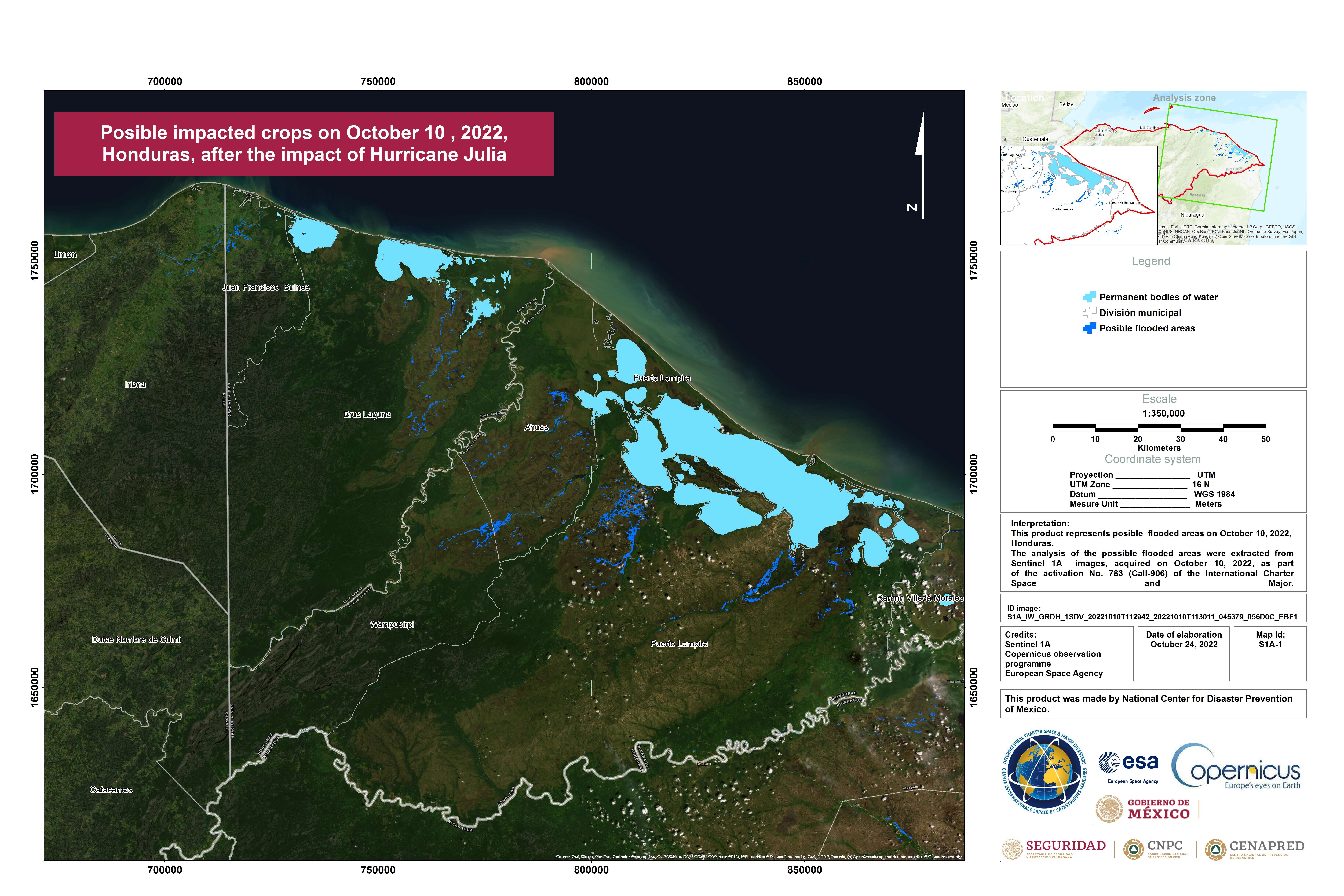
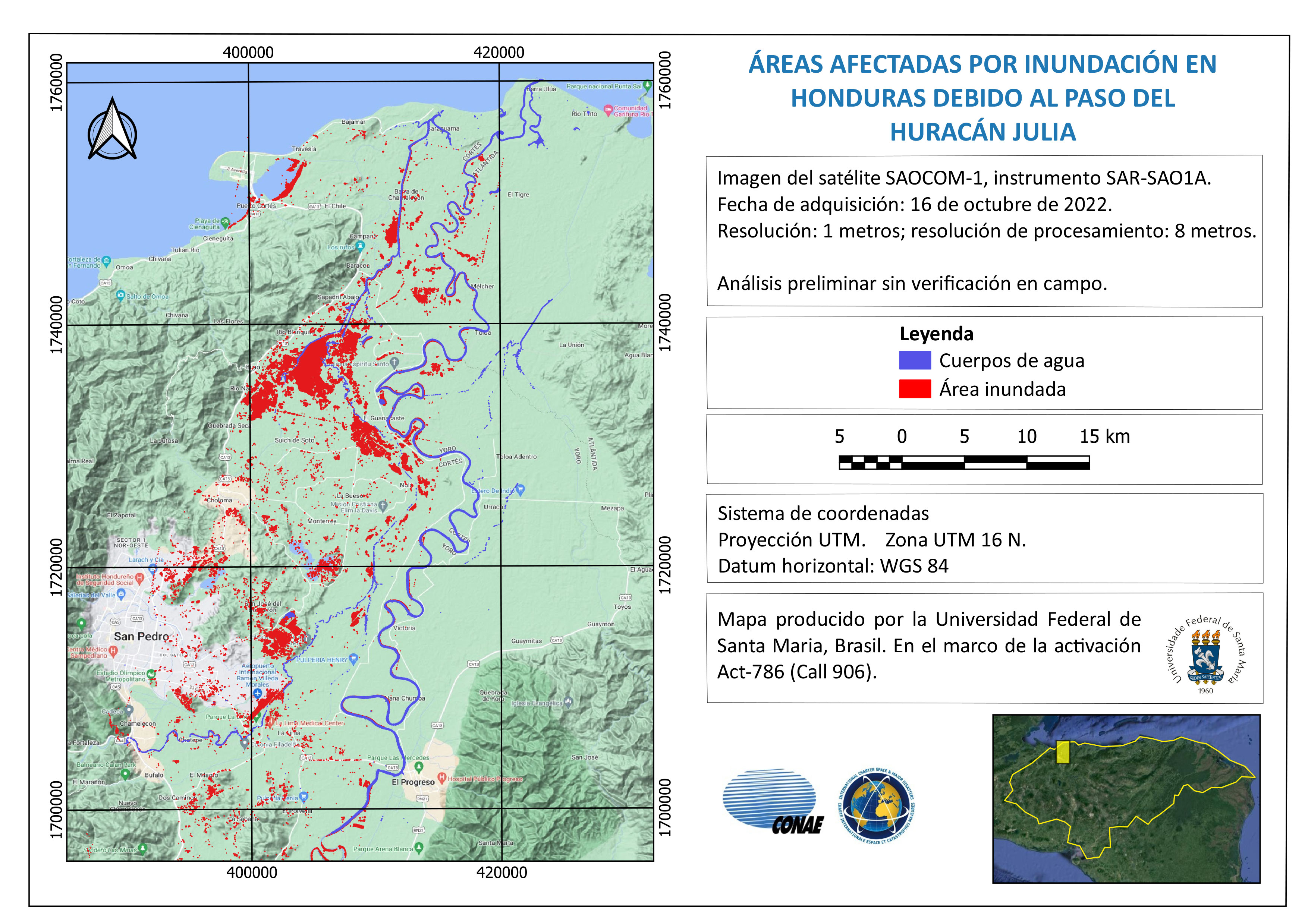
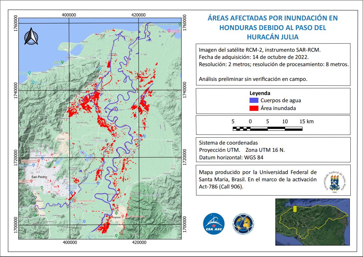
Possible flooded areas on 13 October 2022 in the Sula Valley, Honduras after the impact of hurricane of Julia.

版权: Contains modified Copernicus Sentinel data (2022)
Map produced by The National Centre for Disaster Prevention of Mexico

Information about the Product

已获得: 13/10/2022

源: Sentinel-2

类别: Delineation Map

Flooded areas in Honduras

版权: RADARSAT Constellation Mission Imagery © Government of Canada (2022) - RADARSAT is an official mark of the Canadian Space Agency
Map produced by the Federal University of Santa Maria, Brazil

Information about the Product

已获得: 14/10/2022

源: RCM

类别: Reference Map

Flooding in Honduras

版权: Includes Pleiades material © CNES (2022), Distribution Airbus DS.
Map produced by United Nations Office for Outer Space Affairs

Information about the Product

已获得: 13/10/2022

源: Pleiades

类别: Grading Map

返回完整的响应档案