 English
 Spanish
 French
 Chinese
 Russian
 Portuguese
 Última Activación
Charter activations
Kahramanmaras earthquakes in Türkiye
Two powerful earthquakes hit parts of Türkiye and Northern Syria within the space of 12 hours destroying hundreds of buildings and claiming the lives of thousands.
The quake in Türkiye was centred in the town of Pazarcik in Kahramanmaras province, south-east Türkiye, at a depth of six miles, and there were several powerful aftershocks measuring as strong as 6.7. Several buildings were destroyed, with many people trapped under the rubble.
Nearly 240,000 rescuers continue to work in the worst affected areas, though no survivors have been found recently. The number of people killed by the earthquakes earlier this month has now passed 50,000, according to the latest figures from both countries.
Related News and Resources:
| Type of Event: | Earthquake |
| Location of Event: | Türkiye |
| Date of Charter Activation: | 2023-02-06 |
| Time of Charter Activation: | 07:04 |
| Time zone of Charter Activation: | UTC+03:00 |
| Charter Requestor: | Disaster and Emergency Management Authority of Türkiye (AFAD). |
| Activation ID: | 797 |
| Project Management: | Oktay Gokce (AFAD(Disaster and Emergency Management Presidency of Türkiye)) |
| act-value-adders: | Copernicus EMS Shumin Wang (Institue of Earthquake Forecasting China. (CEA)) Elif Sertel (Istanbul Technical University) Han Oh (KARI) Sebastian LANGER (Palladium) Pedro Youssef (CENAD) Mohammed Al Zeidi (UAESA) Haluk Cetin (Murray University) Jose BisinotiNeto (CENAD) Mustafa Ahmet pesen (Middle East Technical University) |
| Activation handled in collaboration with Copernicus Emergency Management Service |
Products

Damage after Earthquakes in Kahramanmaras, Türkiye
Copyright: BlackSky Technology Inc. (On behalf of itself and its Affiliates, collectively "BlackSky") provides notification that its imagery and logos are trademarked and under copyrights of BlackSky. The further use and/or dissemination of this imagery and/or any product in any way derived there from are restricted without express prior written permission.
Map produced by Geo-information Systems.
Information about the Product
Acquired: 11/03/2023
Source: Global
Category: Delineation Map

Collapsed buildings in Meydan Mahallesi of Iskenderun-Hatay, Turkiye
Copyright: Includes Pleiades material © CNES (2023), Distribution Airbus DS.
Map produced by Istanbul Technical University Department of Geomatics engineering Remote sensing Lab (İTÜ).
Information about the Product
Acquired: 09/02/2023
Source: Pleiades
Category: Delineation Map

Collapsed Buildings in Cay Mahallesi of Iskenderun, Hatay, Turkiye
Copyright: Includes Pleiades material © CNES (2022), Distribution Airbus DS.
Map produced by Istanbul Technical University Department of Geomatics engineering Remote sensing Lab (İTÜ).
Information about the Product
Acquired: 23/07/2022 and 09/02/2023
Source: Pleiades
Category: Delineation Map


Damage after Earthquakes in the Hatay Province, Kirikhan, Türkiye
Copyright: © (2023) DigitalGlobe, Inc., Longmont CO USA 80503.
DigitalGlobe and the DigitalGlobe logos are trademarks of DigitalGlobe, Inc.
The use and/or dissemination of this data and/or of any product in any way derived there from are restricted. Unauthorized use and/or dissemination is prohibited.
Map produced by the National Academy of Sciences of Belarus: Geoinformation Systems.
Information about the Product
Acquired: 20/02/2023
Source: WorldView-1
Category: Grading Map

Collapsed Buildings and Temporary Shelters in the Centre of Kahranmaras, Turkiye
Copyright: Includes Pleiades material © CNES (2023), Distribution Airbus DS.
Map produced by Istanbul Technical University Department of Geomatics engineering Remote sensing Lab (İTÜ).
Information about the Product
Acquired: 07/02/2023
Source: Pleiades
Category: Delineation Map

Collapsed Buildings in the Centre of Kahramanmaraş, Turkiye
Copyright: Includes Pleiades material © CNES (2023), Distribution Airbus DS.
Map produced by Istanbul Technical University Department of Geomatics engineering Remote sensing Lab (İTÜ).
Information about the Product
Acquired: 07/02/2023
Source: Pleiades
Category: Delineation Map


Collapsed buildings in Samandag, Hatay, Turkiye
Copyright: Includes Pleiades material © CNES (2023), Distribution Airbus DS.
Map produced by Istanbul Technical University Department of Geomatics Engineering Remote Sensing Lab (İTÜ).
Information about the Product
Acquired: 11/02/2023
Source: Pleiades
Category: Delineation Map
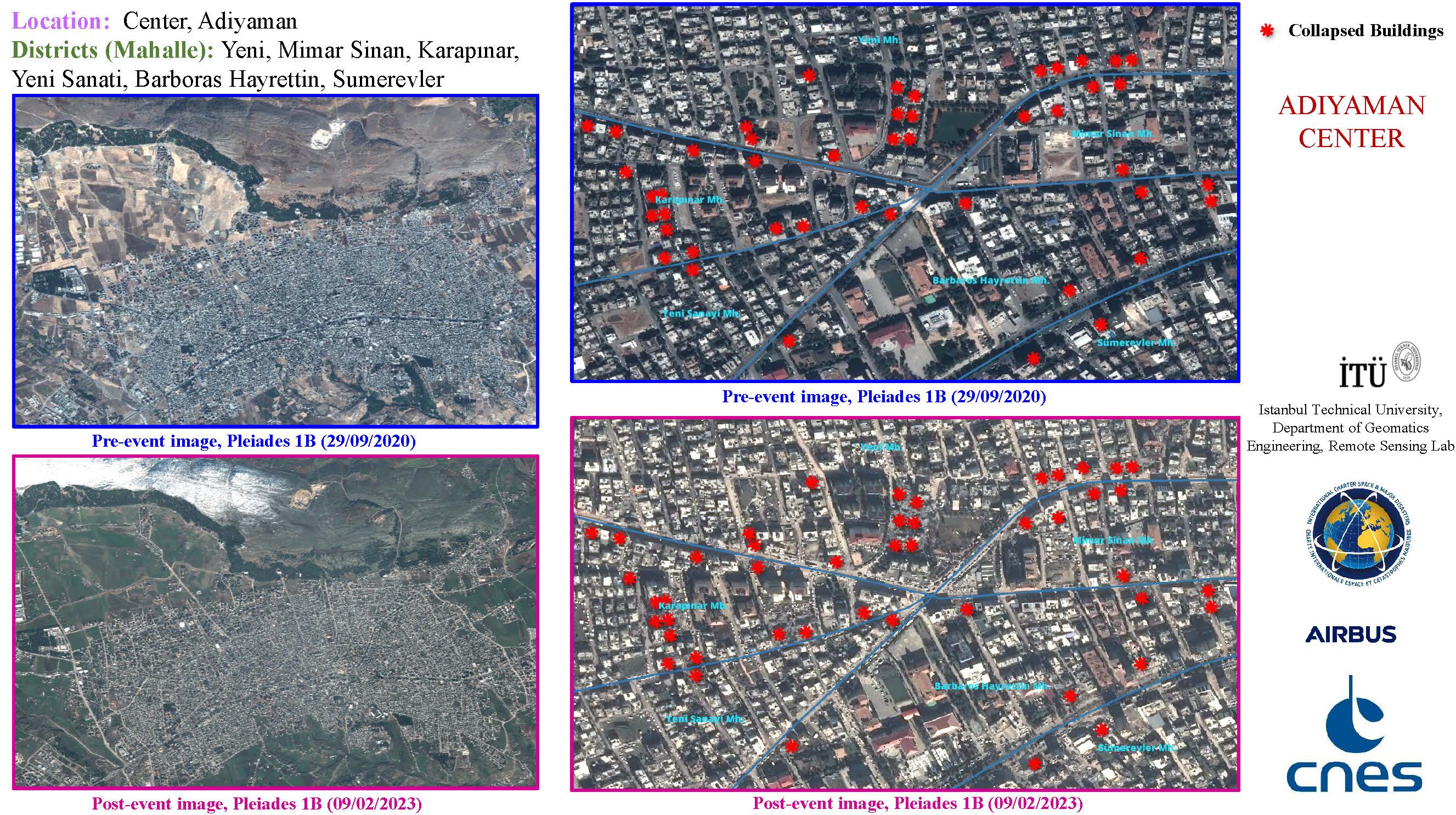
Collapsed Buildings in different districts in the Centre of Adiyaman, Turkiye
Copyright: Includes Pleiades material © CNES (2020), Distribution Airbus DS.
Map produced by Istanbul Technical University Department of Geomatics engineering Remote sensing Lab (İTÜ).
Information about the Product
Acquired: 29/09/2020 and 09/02/2023
Source: Pleiades
Category: Delineation Map

Collapsed Buildings in the Centre of Adiyaman, Turkiye
Copyright: Includes Pleiades material © CNES (2023), Distribution Airbus DS.
© Planet Labs Inc. (2023)
Map produced by Istanbul Technical University Department of Geomatics engineering Remote sensing Lab (İTÜ).
Information about the Product
Acquired: Pleiades: 09/02/2023
SkySat: 11/02/2023
Source: Pleiades and SkySat
Category: Delineation Map


Collapsed and Damages buildings at the Center of Kirikhan, Hatay, Turkiye
Copyright: Includes Pleiades material © CNES (2023), Distribution Airbus DS.
Map produced by Istanbul Technical University Department of Geomatics Engineering Remote Sensing Lab (İTÜ).
Information about the Product
Acquired: 08/02/2023
Source: Pleiades
Category: Reference Map


Spatial Distribution of Collapsed Buildings in the Centre of Adiyaman, Turkiye
Copyright: © Planet Labs Inc. (2023)
Map produced by Istanbul Technical University Department of Geomatics engineering Remote sensing Lab (İTÜ).
Information about the Product
Acquired: 11/02/2023 and 15/02/2023
Source: SkySat
Category: Delineation Map

Collapsed Buildings in Adiyaman City Center, Turkiye
Copyright: Includes Pleiades material © CNES (2023), Distribution Airbus DS.
Map produced by Istanbul Technical University Department of Geomatics Engineering Remote Sensing Lab (İTÜ).
Information about the Product
Acquired: 29/09/2020 and 09/02/2023
Source: Pleiades
Category: Reference Map

Collapsed Buildings in the Outer Districts of Kirikhan, Hatay, Turkiye
Copyright: Includes Pleiades material © CNES (2023), Distribution Airbus DS.
Contains modified Copernicus Sentinel data (2023).
Map produced by Istanbul Technical University.
Information about the Product
Acquired: 08/02/2023
Source: Pleiades and Sentinel-2
Category: Delineation Map


Collapsed Buildings in Esenevler District, Osmaniye, Turkiye
Copyright: Includes Pleiades material © CNES (2023), Distribution Airbus DS.
Contains modified Copernicus Sentinel data (2023).
Map produced by Istanbul Technical University.
Information about the Product
Acquired: 07/02/2023
Source: Pleiades and Sentinel-2
Category: Delineation Map

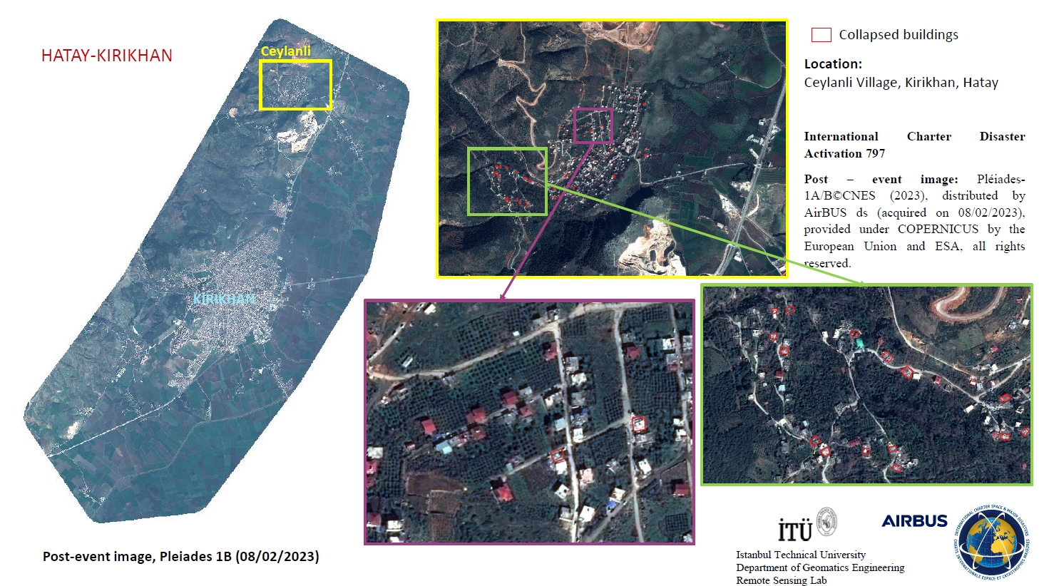
Damaged buildings in Ceylanli Village, Hatay, Turkiye
Copyright: Includes Pleiades material © CNES (2023), Distribution Airbus DS.
Contains modified Copernicus Sentinel data (2023).
Map produced by Istanbul Technical University.
Information about the Product
Acquired: 08/02/2023
Source: Pleiades and Sentinel-2
Category: Delineation Map

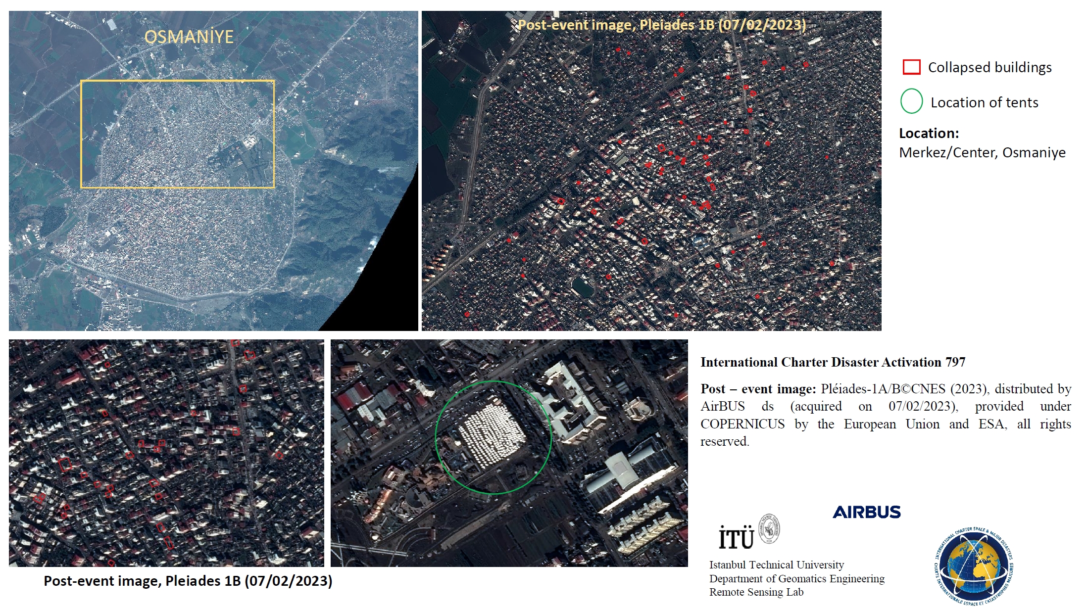
Collapsed Buildings and Aid Tents in Osmaniye Center, Turkiye
Copyright: Includes Pleiades material © CNES (2023), Distribution Airbus DS.
Contains modified Copernicus Sentinel data (2023).
Map produced by Istanbul Technical University.
Information about the Product
Acquired: 07/02/2023
Source: Pleiades and Sentinel-2
Category: Delineation Map


Earthquake damage in the Hatay Province, Kirikhan in Türkiye
Copyright: © (2023) DigitalGlobe, Inc., Longmont CO USA 80503.
DigitalGlobe and the DigitalGlobe logos are trademarks of DigitalGlobe, Inc. The use and/or dissemination of this data and/or of any product in any way derived there from are restricted. Unauthorized use and/or dissemination is prohibited.
Map produced by the National Academy of Sciences of Belarus: Geoinformation Systems.
Information about the Product
Acquired: 09/02/2023
Source: WorldView-2
Category: Grading Map

Light Loss Assessment following the Marash/Antep Earthquake using Night-time Light Imagery in Turkiye
Download the Full Report
Copyright: Origin Space Co., Ltd., China
International Research Center of Big Data for Sustainable Development Goals (CBAS)
Copyright : NASA
Report produced by UNITAR/UNOSAT.
Information about the Product
Acquired: Yangwang-1 Space Telescope: 09/02/2023,11/02/2023
VIIRS: 23/08/2022
SDGSAT-1: 23/08/2022
Source: Yangwang-1 Space Telescope, VIIRS and SDGSAT-1
Category: Gradient Monitoring Maps

Across track displacement using pixel tracking from RADARSAT-2 imagery in Turkiye
Copyright: RADARSAT-2 Data and Products © Maxar Technologies Ltd. (2023) – All Rights Reserved.
RADARSAT is an official mark of the Canadian Space Agency.
Map produced by the Canada centre for Mapping and Earth Observation, Natural resources Canada.
Information about the Product
Acquired: 07/02/2023
Source: RADARSAT-2
Category: Reference Map

Damage Assessment of Arslantepe Mound, Battalgazi District, Malatya Province, Türkiye
Copyright: © (2023) DigitalGlobe, Inc., Longmont CO USA 80503.
DigitalGlobe and the DigitalGlobe logos are trademarks of DigitalGlobe, Inc. The use and/or dissemination of this data and/or of any product in any way derived there from are restricted. Unauthorized use and/or dissemination is prohibited.
Map produced by UNITAR/UNOSAT.
Information about the Product
Acquired: 09/02/2023
Source: WorldView-2
Category: Grading Map

Damage assessment of Antakya and Hatay, Türkiye
Copyright: WorldView-2 © (2022) DigitalGlobe, Inc., Longmont CO USA 80503.
DigitalGlobe and the DigitalGlobe logos are trademarks of DigitalGlobe, Inc. The use and/or dissemination of this data and/or of any product in any way derived there from are restricted. Unauthorized use and/or dissemination is prohibited.
Includes Pleiades material © CNES (2023), Distribution Airbus DS.
Map produced by KARI.
Information about the Product
Acquired: WorldView-2 : 22/12/2022
Pleiades: 07/02/2023
Source: WorldView-2 and Pleiades
Category: Delineation Map


Earthquake damage in Adiyaman, Türkiye
Copyright: WorldView-2 © Maxar Technologies, Inc. (2023), provided under COPERNICUS by the European Union, ESA and European Space Imaging, all right reserved.
Includes Pleiades material © CNES (2023), Distribution Airbus DS.
Map produced by Copernicus EMS.
Information about the Product
Acquired: WorldView-2: 09/02/2023
Pleiades: 08/02/2023
Source: WorldView-2 and Pleiades
Category: Grading Map


Earthquake damage in Diyarbakir, Türkiye
Copyright: Includes Pleiades material © CNES (2023), Distribution Airbus DS.
WorldView-2 © Maxar Technologies, Inc (2023), provided under Copernicus by the European Union, ESA and European Space Imaging, all rights reserved.
Map produced by Copernicus EMS.
Information about the Product
Acquired: Pleiades: 09/02/2023
WorldView-2: 09/02/2023
Source: Pleiades and WorldView-2
Category: Grading Map


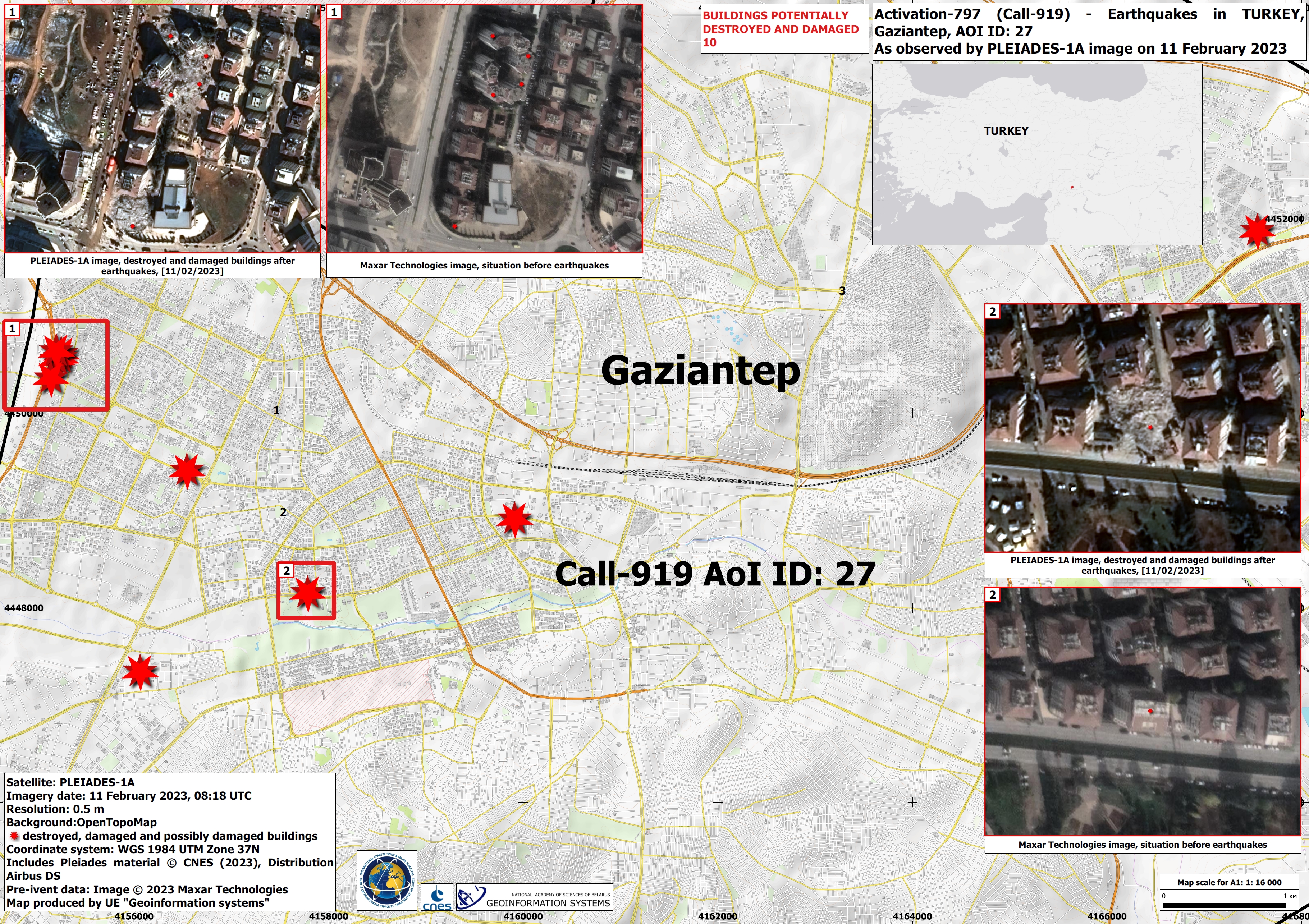
Earthquakes in the Gaziantep province, Islahiye in Türkiye
Copyright: © (2023) DigitalGlobe, Inc., Longmont CO USA 80503.
DigitalGlobe and the DigitalGlobe logos are trademarks of DigitalGlobe, Inc.
The use and/or dissemination of this data and/or of any product in any way derived there from are restricted. Unauthorized use and/or dissemination is prohibited.
Map produced by UE Geoinformation Systems.
Information about the Product
Acquired: 07/02/2023
Source: WorldView-3
Category: Grading Map


 Back to the full activation archive

