 English
 Spanish
 French
 Chinese
 Russian
 Portuguese
 Последняя Активация
Charter activations
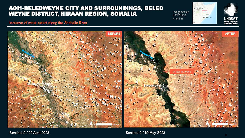
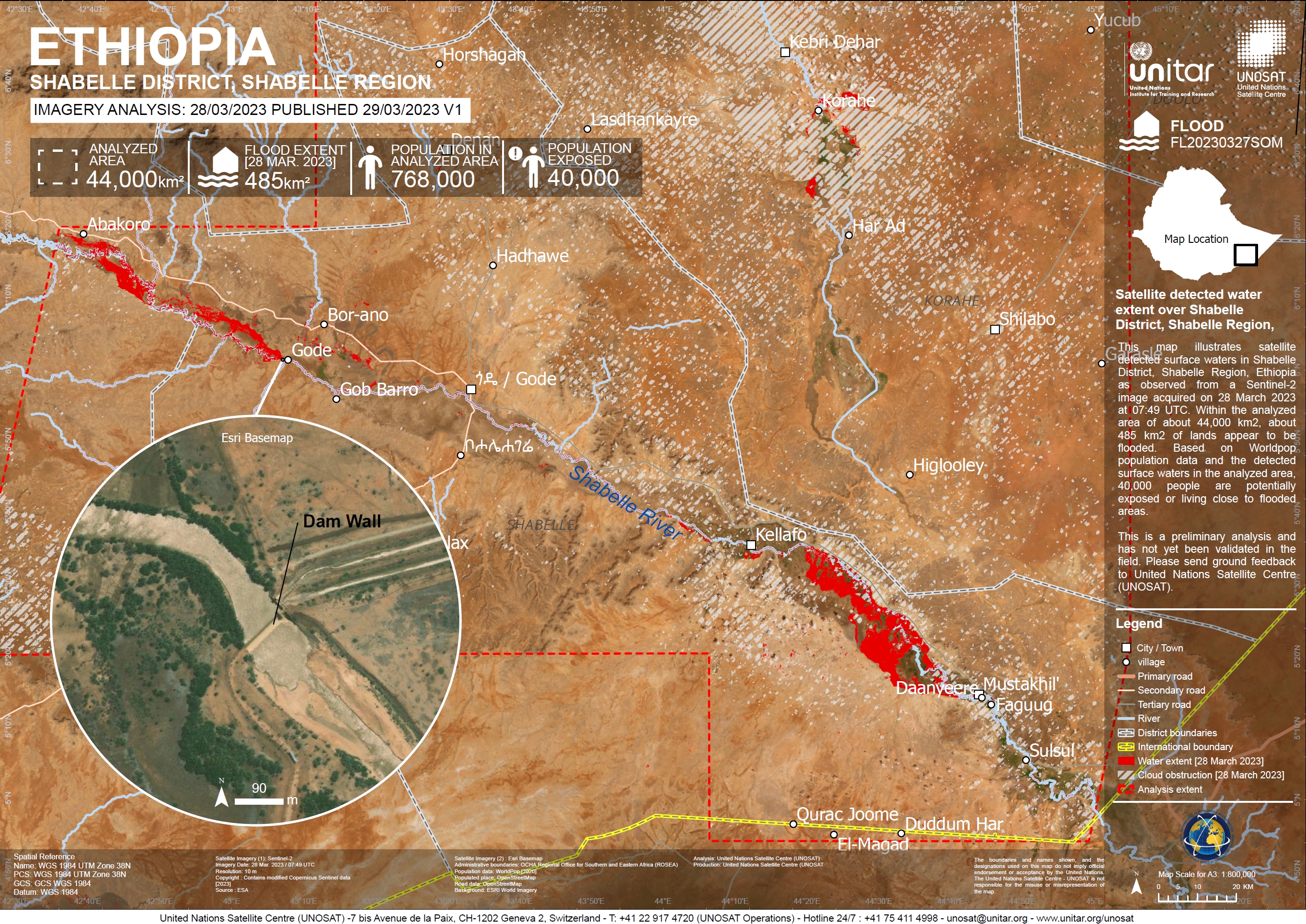
Flooding in Somalia and Ethiopia
Flash floods caused by heavy rains have killed at least 14 people, displaced thousands more, and destroyed properties and homes in several areas of Somalia signalling an early start of the Gu rainy season, which usually runs from April to June.
Those who have lost their homes are now living in makeshift shelters on higher ground, which are severely overcrowded and lack water and sanitation facilities. The Somali Disaster Management Agency (SoDMA) said it is the worst flooding in almost a decade.
Heavy rain in the Ethiopian Highlands has also made its way downstream, increasing river levels in Somalia.
Related News and Resources:
| Тип события: | Floods |
| Место события: | Somalia and Ethiopia |
| Date of Charter Activation: | 2023-03-27 |
| Время активации Хартии: | 14:30 |
| TЧасовой пояс в районе активации Хартии: | UTC+02:00 |
| Запрос на активацию поступил от: | UNITAR on behalf of Food and Agriculture Organization of the United Nations (FAO) |
| Номер активации: | 813 |
| Менеждер проекта от: | Ida Svendsen (UNOSAT) |
Products
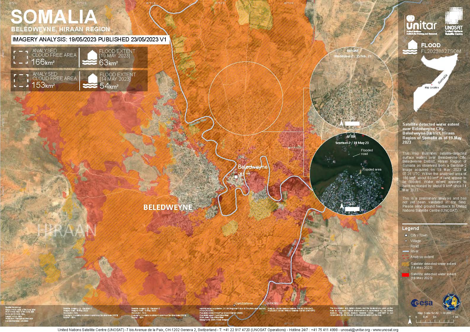
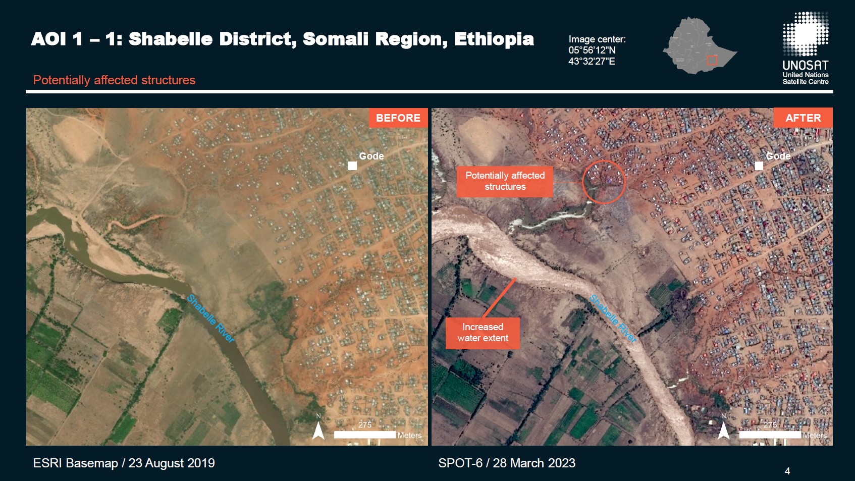
Flood Assessment over Beledweyne City, Hiraan Region, and Jowhar City, Middle Shebelle Region, Somalia
Download the full report
Авторские права: Contains modified Copernicus Sentinel data (2023)
Report produced by UNITAR/UNOSAT
Information about the Product
Получено: 19/05/2023
Источник: Sentinel-2
Категория: Delineation Map
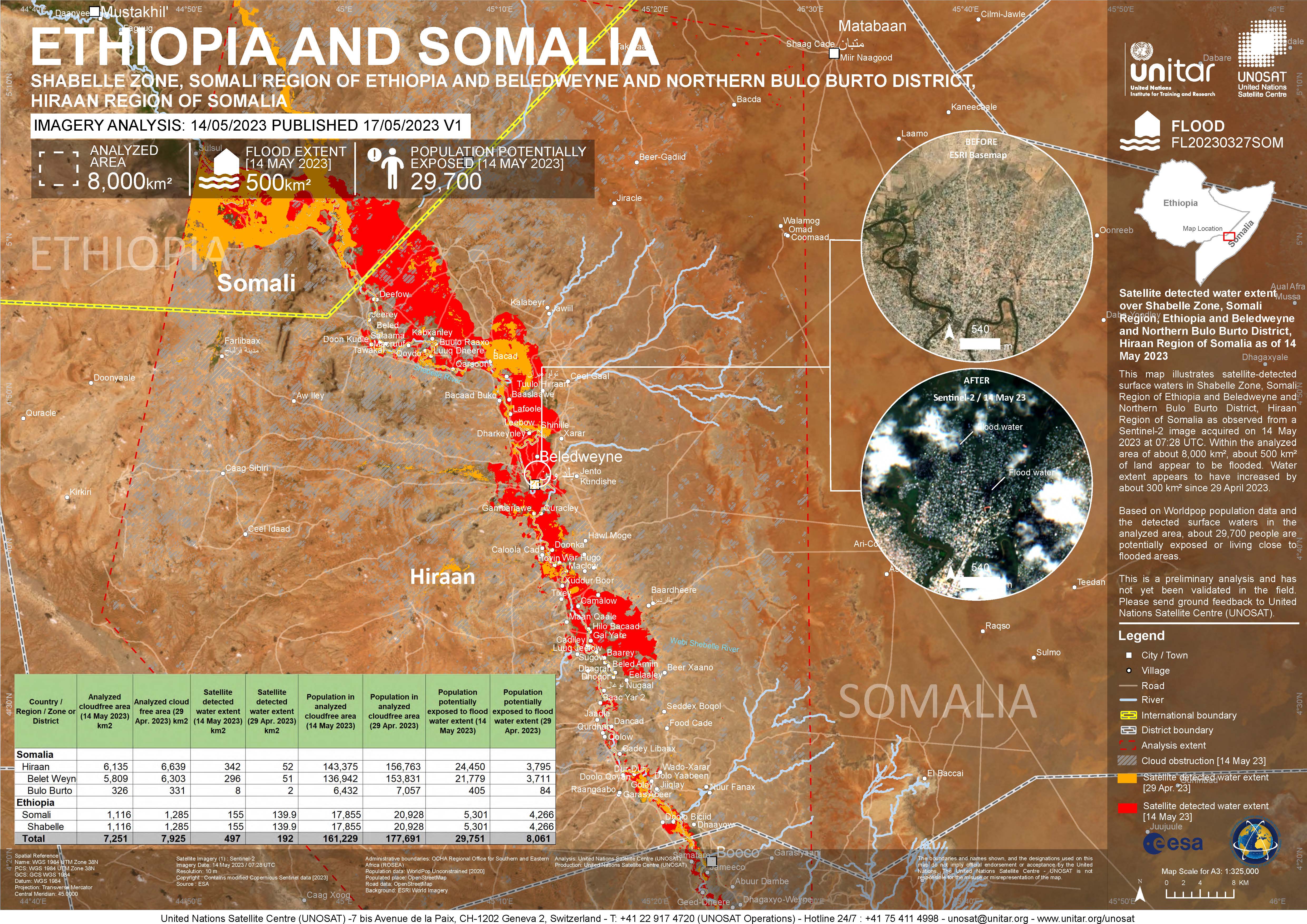
Satellite detected water extent over Shabelle Zone, Somali Region, Ethiopia and Beledweyne and Northern Bulo Burto District, Hiraan Region of Somalia
Авторские права: Contains modified Copernicus Sentinel data (2023)
Map produced by UNITAR / UNOSAT
Information about the Product
Получено: 14/05/2023
Источник: Sentinel-2
Категория: Delineation Map
Preliminary Satellite Derived Flood Assessment for Bulo Burto City, Hiraan Region and Jowhaar City, Middle Shebelle Region in Somalia
Download the full report
Авторские права: WorldView © (2023) DigitalGlobe, Inc., Longmont CO USA 80503. DigitalGlobe and the DigitalGlobe logos are trademarks of DigitalGlobe, Inc.
The use and/or dissemination of this data and/or of any product in any way derived there from are restricted. Unauthorized use and/or dissemination is prohibited
USGS/NASA Landsat Program
Contains modified Copernicus Sentinel data (2023)
© 2004 GeoEye NextView License
Report produced by UNOSAT/UNITAR
Information about the Product
Получено: Sentinel-2: 02/05/2023
WorldView-3: 02/05/2023
WorldView-2: 03/04/2023
GeoEye-1: 04/03/2023
Landsat 9: 29/04/2023
Источник: Sentinel-2, WorldView-3, WorldView-2, GeoEye-1 and Landsat 9
Категория: Delineation Map
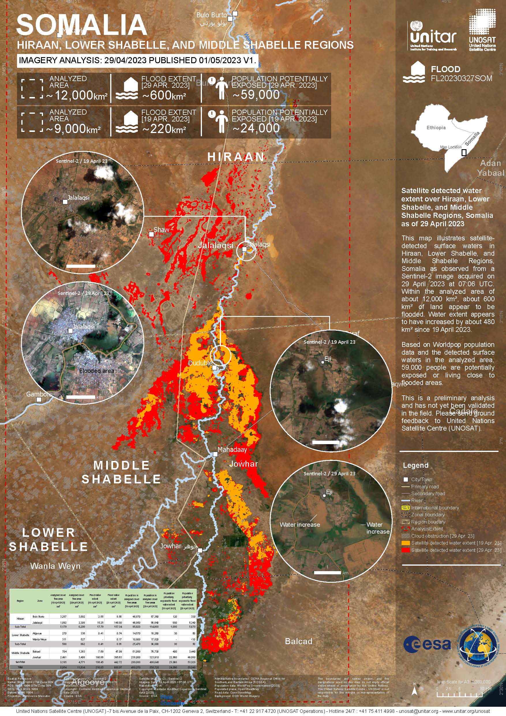
Satellite detected water extent over Hiraan, Lower Shabelle, and Middle Shabelle Regions, Somalia
Авторские права: Contains modified Copernicus Sentinel data (2023)
Map produced by UNITAR / UNOSAT
Information about the Product
Получено: 28/02/2023,19/04/2023
Источник: Sentinel-2
Категория: Delineation Map
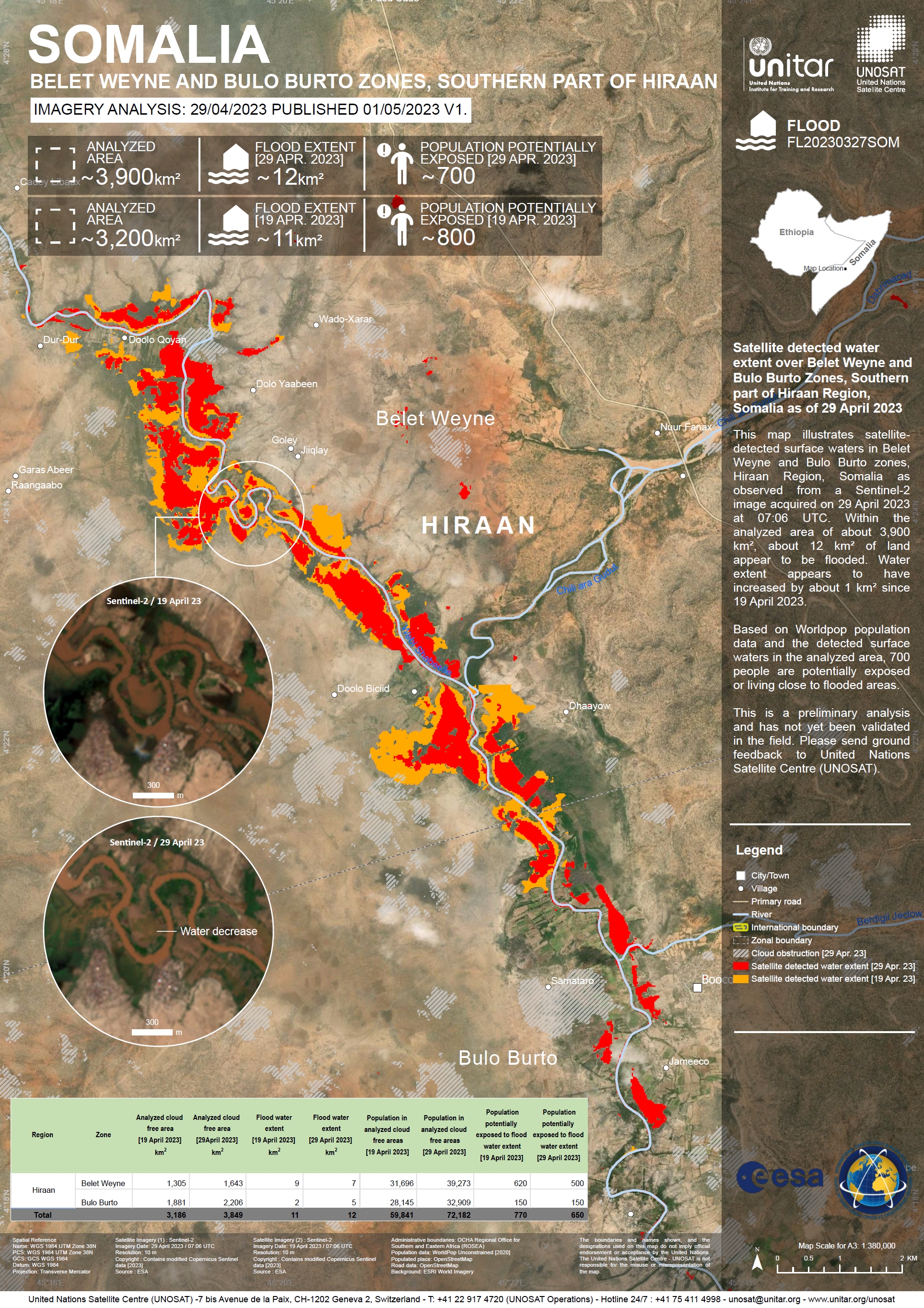
Satellite detected water extent over the Belet Weyne and Bulo Burto Zones, Hiraan Region, Somalia
Авторские права: Contains modified Copernicus Sentinel data (2023)
Map produced by UNOSAT and UNITAR.
Information about the Product
Получено: 19/04/2023 and 29/04/2023
Источник: Sentinel-2
Категория: Delineation Map
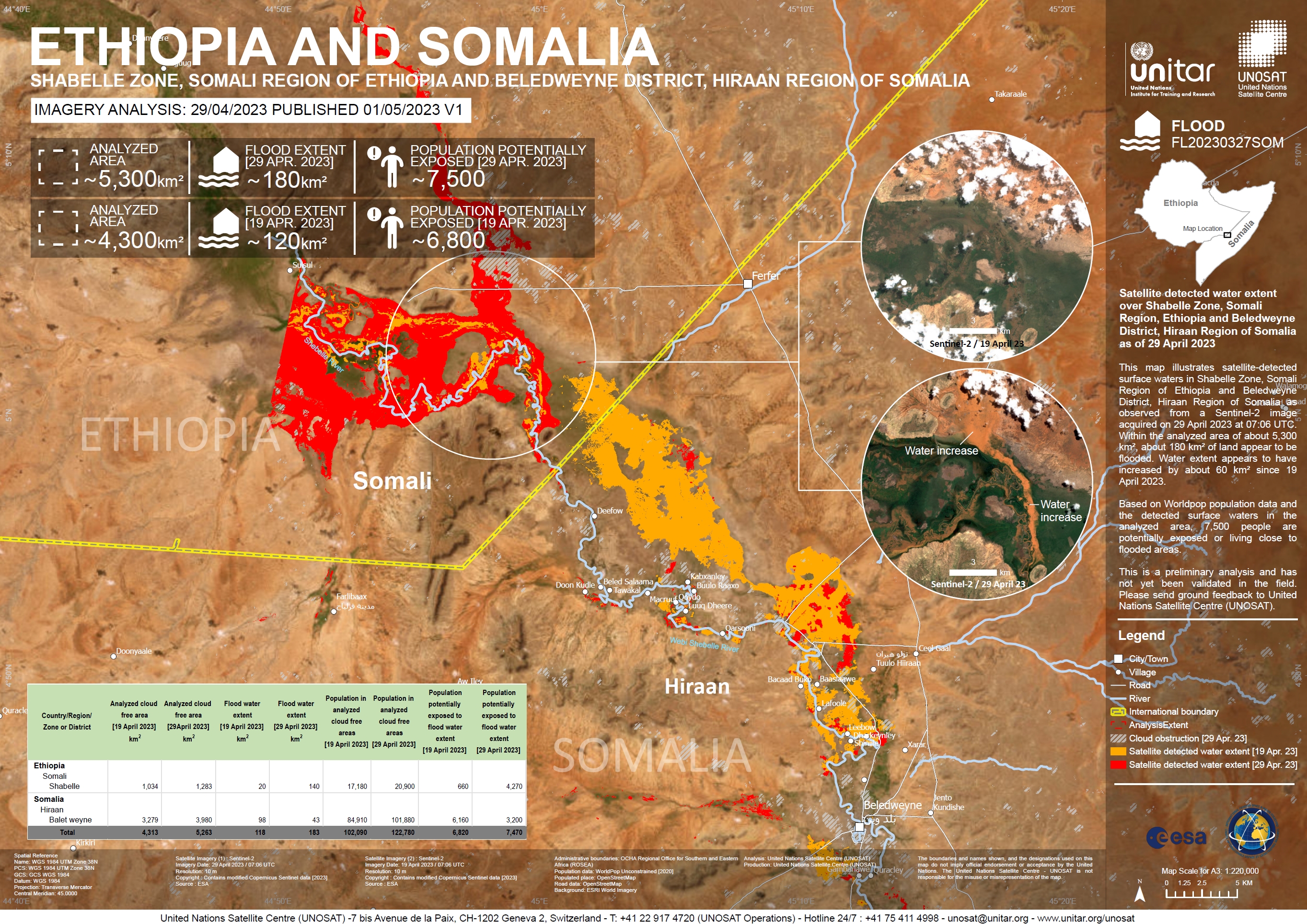
Satellite detected water extent over the Shabelle Zone, Somali Region, Ethiopia and Beledweyne District, Hiraan Region, Somalia
Авторские права: Contains modified Copernicus Sentinel data (2023)
Map produced by UNOSAT and UNITAR.
Information about the Product
Получено: 19/04/2023 and 29/04/2023
Источник: Sentinel-2
Категория: Delineation Map
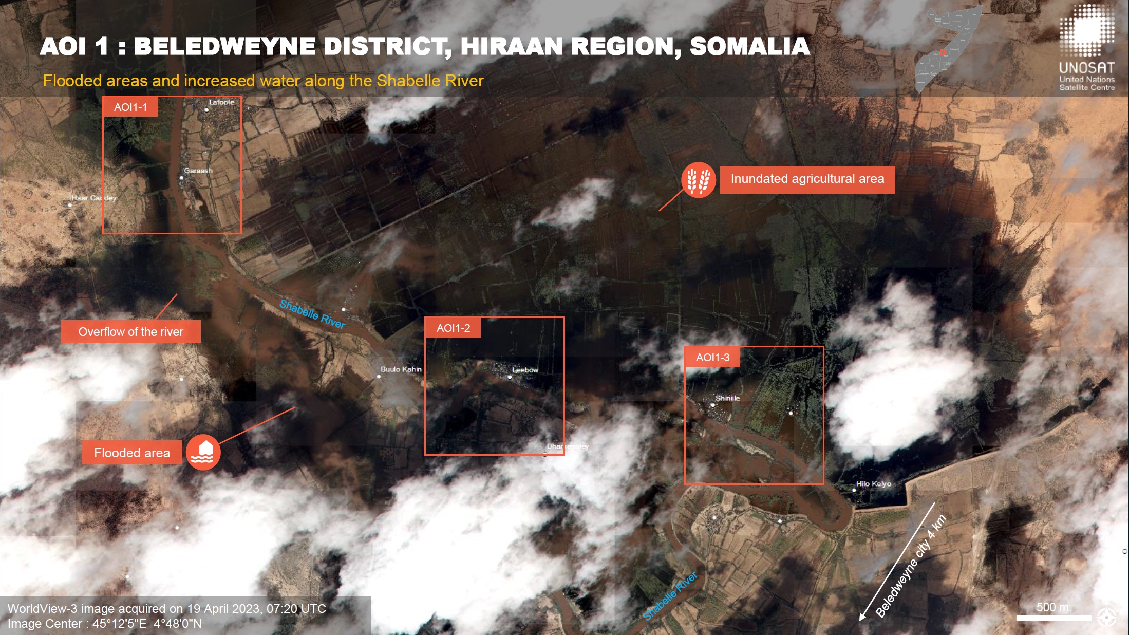
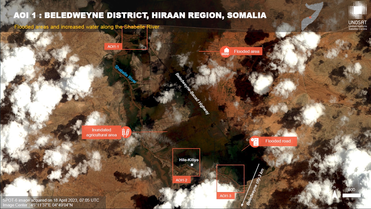
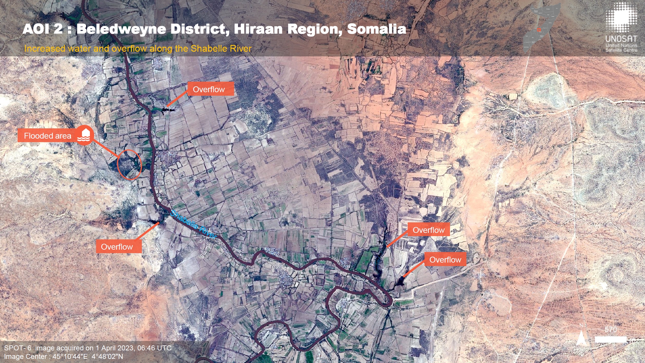
Preliminary Satellite Flood Assessment Report in the Beledweyne District, Hiraan Region, Somalia
Download Full Report
Авторские права: Includes material © AIRBUS DS (2023)
© (2023) DigitalGlobe, Inc., Longmont CO USA 80503. DigitalGlobe and the DigitalGlobe logos are trademarks of DigitalGlobe, Inc.
The use and/or dissemination of this data and/or of any product in any way derived there from are restricted.
Unauthorized use and/or dissemination is prohibited.
Report produced by UNOSAT and UNITAR.
Information about the Product
Получено: WorldView-3: 12/04/2022, 31/03/2023 and 19/04/2023
SPOT-6: 18/04/2023 and 20/04/2023
KOMPSAT-3: 20/04/2023
Источник: WorldView-3, SPOT-6 and KOMPSAT-3
Категория: Delineation Map
Preliminary Satellite Flood Assessment Report, Beledweyne District, Hiraan Region, Somalia
Download Full Report
Авторские права: Includes material © AIRBUS DS (2023)
© 21AT (2023)
Report produced by UNOSAT and UNITAR.
Information about the Product
Получено: JILIN-1: 09/04/2023
SPOT-6: 18/04/2023
Источник: JILIN-1 and SPOT-6
Категория: Delineation Map
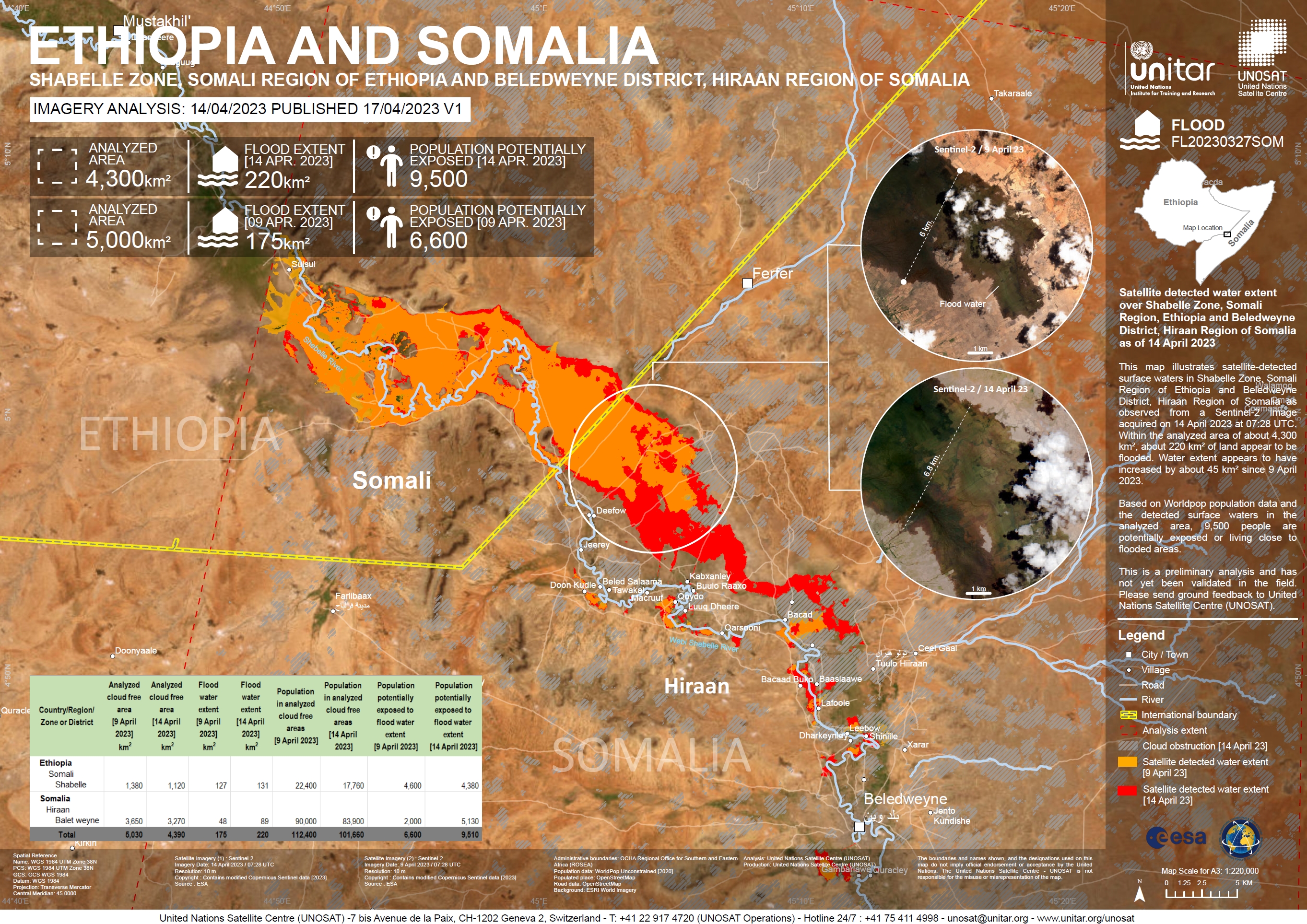
Satellite Detected Flooding over the Shabelle Zone, Somali Region of Ethiopia and the Beledweyne District, Hiraan Region of Somalia
Авторские права: Contains modified Copernicus Sentinel data (2023)
Map produced by UNOSAT and UNITAR.
Information about the Product
Получено: 09/04/2023 and 14/04/2023
Источник: Sentinel-2
Категория: Delineation Map
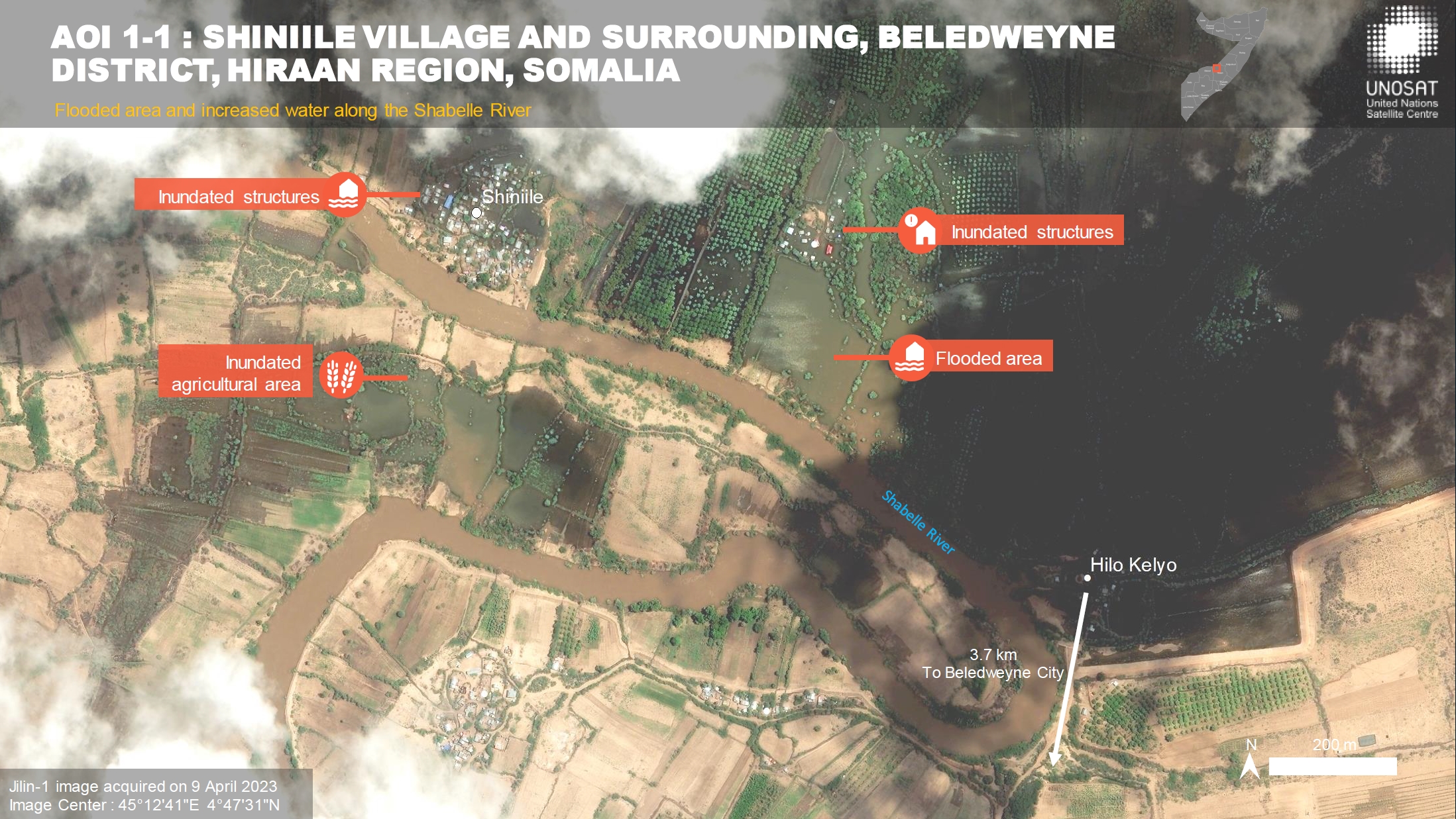
Preliminary Satellite Flood Assessment Report, Beledweyne City, Hiraan Region, Somalia
Download Full Report
Авторские права: Sentinel-2 © Contains modified Copernicus Sentinel data (2023)
JINLIN-1 © 21AT (2023)
Report produced by UNOSAT and UNITAR.
Information about the Product
Получено: 09/04/2023
Источник: Sentinel-2 and JINLIN-1
Категория: Delineation Map
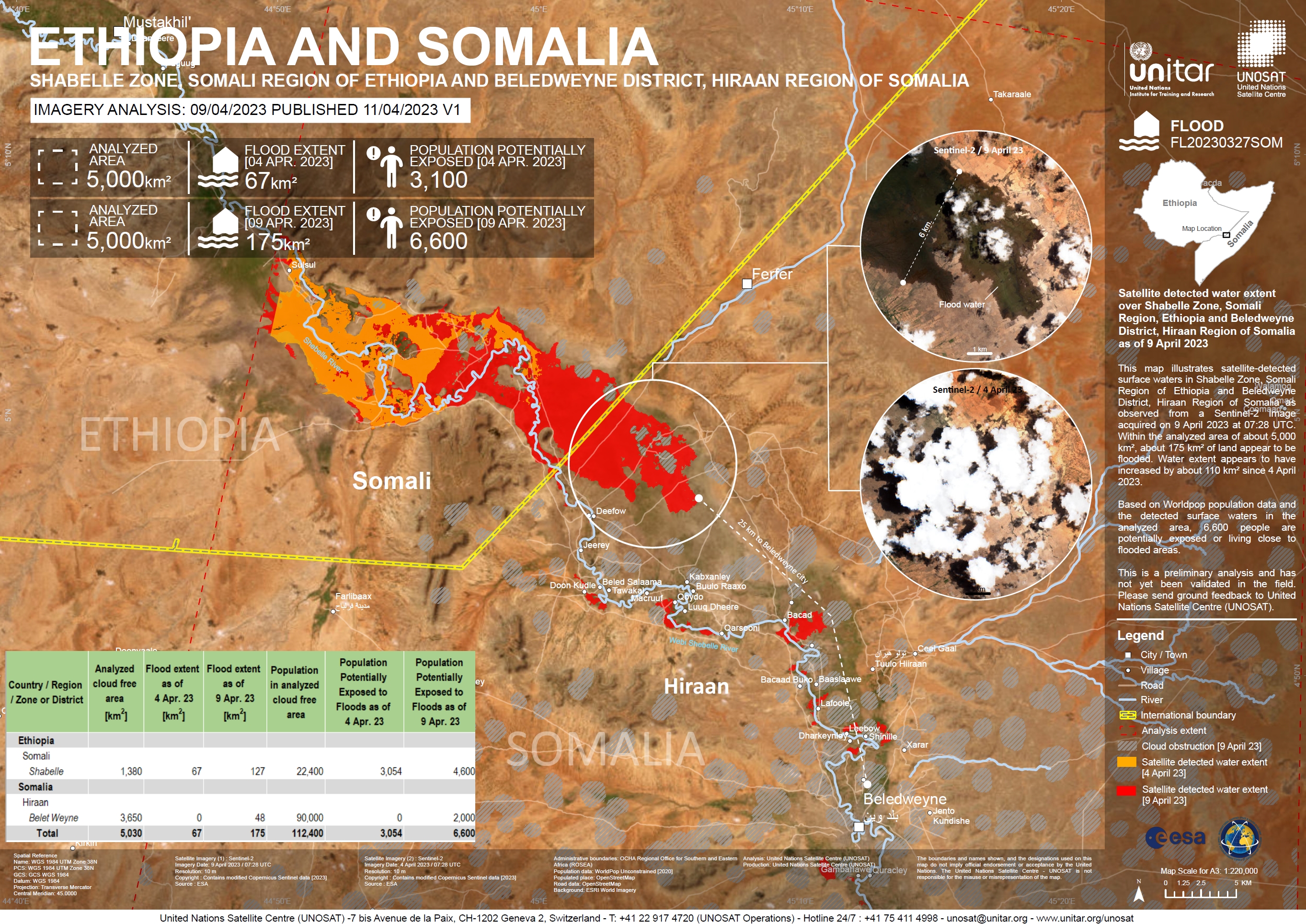
Satellite detected water extent over Shabelle Zone, Somali Region, Ethiopia and Beledweyne District, Hiraan Region of Somalia
Авторские права: Contains modified Copernicus Sentinel data (2023)
Map produced by UNOSAT and UNITAR.
Information about the Product
Получено: 09/04/2023
Источник: Sentinel-2
Категория: Delineation Map
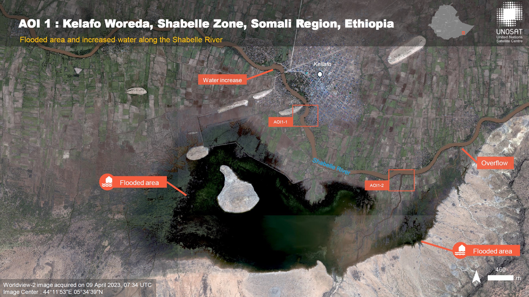
Preliminary Satellite Flood Assessment Report for Beledweyne City, Hiraan Region, Somalia and Kelafo Woreda, Shabelle Zone, Somali Region, Ethiopia
Download Full Report
Авторские права: WorldView-2 © (2023) DigitalGlobe, Inc., Longmont CO USA 80503. DigitalGlobe and the DigitalGlobe logos are trademarks of DigitalGlobe, Inc.
The use and/or dissemination of this data and/or of any product in any way derived there from are restricted.
Unauthorized use and/or dissemination is prohibited.
SPOT-6 © Includes material © AIRBUS DS (2023)
Sentinel-2 © Contains modified Copernicus Sentinel data (2023)
Report produced by UNOSAT and UNITAR.
Information about the Product
Получено: SPOT-6: 30/03/2023
WorldView-2: 09/04/2023
Sentinel-2: 09/04/2023
Источник: WorldView-2, SPOT-6 and Sentinel-2
Категория: Delineation Map
Preliminary satellite-derived flood assessment in Beledweyne City, Somalia and the Somali Region, Ethiopia
Download Full Report
Авторские права: © (2023) DigitalGlobe, Inc., Longmont CO USA 80503. DigitalGlobe and the DigitalGlobe logos are trademarks of DigitalGlobe, Inc.
The use and/or dissemination of this data and/or of any product in any way derived there from are restricted.
Unauthorized use and/or dissemination is prohibited.
Includes material © AIRBUS DS (2023).
Map produced by UNOSAT and UNITAR.
Information about the Product
Получено: WorldView-3: 31/03/2023
SPOT-6: 01/04/2023
Источник: WorldView-3 and SPOT-6
Категория: Delineation Map
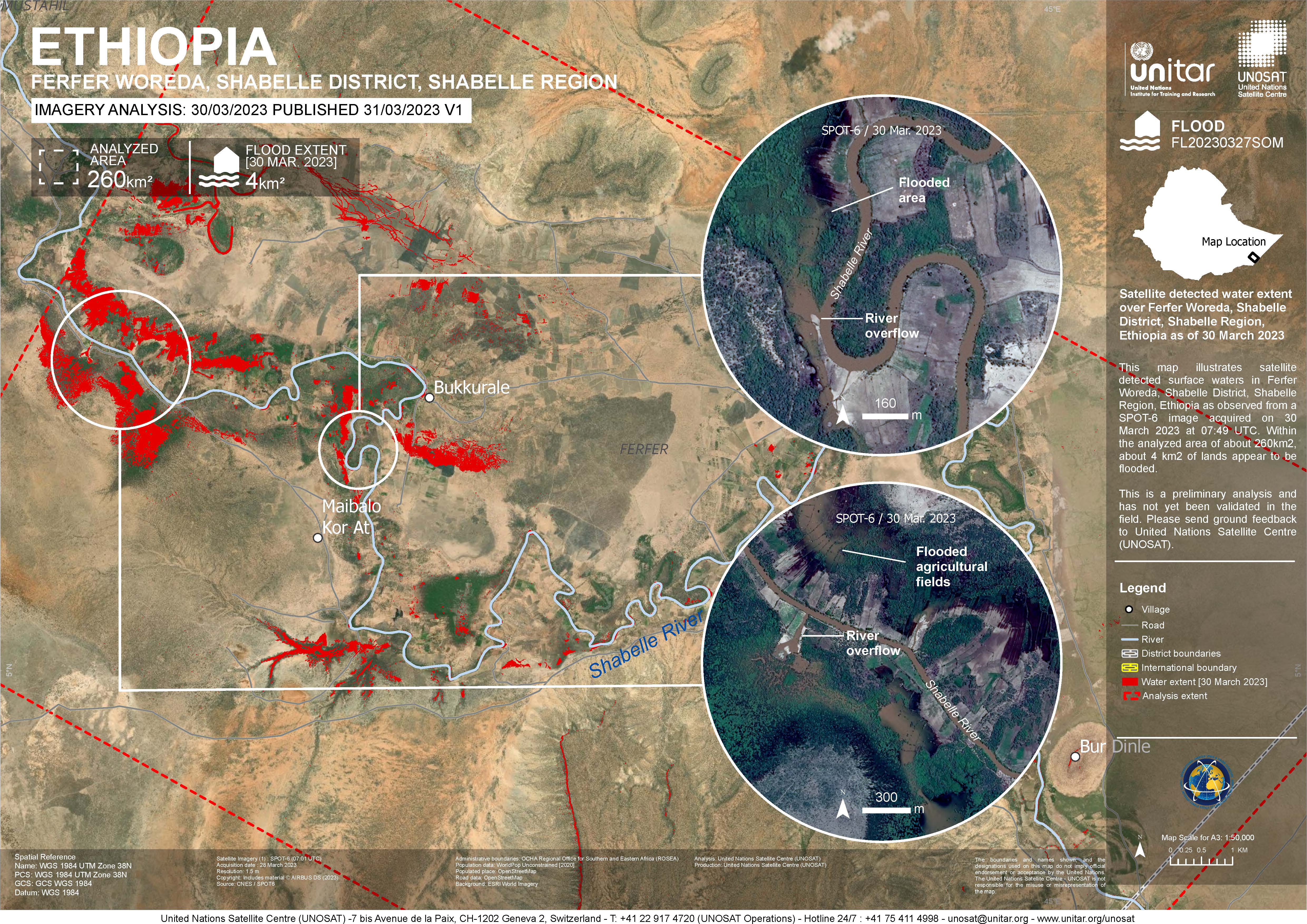
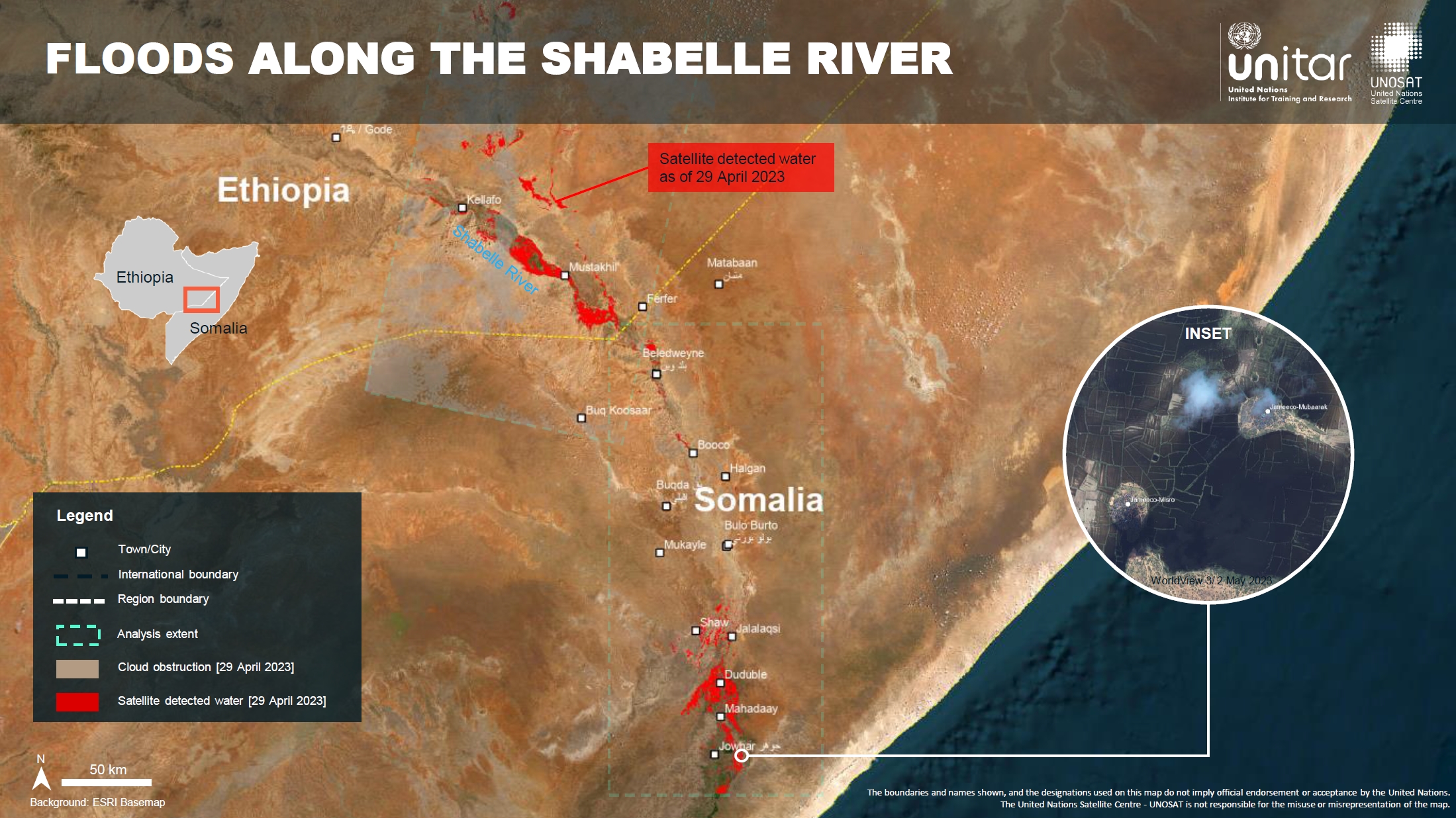
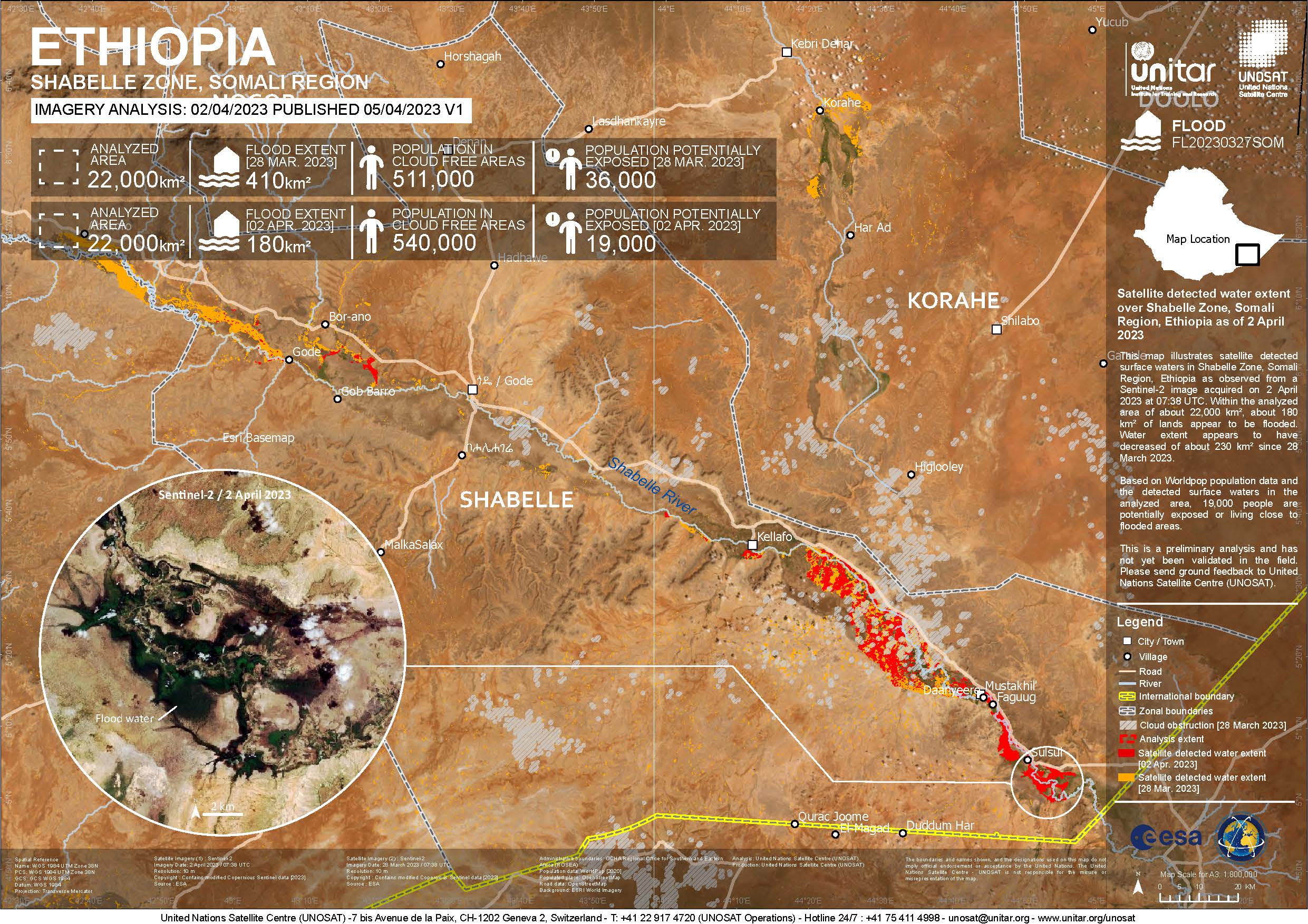
Preliminary Satellite Flood Assessment Report, Hiraan Region, Somalia & Somali Region, Ethiopia
Download full report
Авторские права: Includes material © AIRBUS DS (2023)
Report produced by UNITAR / UNOSAT
Information about the Product
Получено: 28/03/2023
Источник: SPOT-6
Категория: Delineation Map
 Вернуться к полному архиву активаций

