 English
 Spanish
 French
 Chinese
 Russian
 Portuguese
 Latest Activation
Charter activations
Cyclone Yasa in Fiji
Cyclone Yasa - a category 4 storm - is currently due to pass over Fiji on 18 December and is expected to potentially cause flooding, storm surges, and damage.
Yasa is expected to pass over the two main islands in the archipelago - Viti Levu and Vanua Levu - but is also expected to impact the nearby smaller islands. The Nadi Weather Office, Fiji has also forecast potential severe storm surges in coastal areas of Northern Viti Levu, Nadi, Ba, Rakiraki, and possibly Tailevu.
Forecasts suggest the storm may reach category 5 - the highest category on the Saffir-Simpson scale - before it reaches Fiji.
The Fiji Meteorological Service and authorities have warned residents to expect the storm to cause a great deal of damage, and urged those affected to take shelter and be careful.
Related news and resources
| Type of Event: | Storm - Cyclone |
| Location of Event: | Fiji |
| Date of Charter Activation: | 2020-12-15 |
| Time of Charter Activation: | 15:27 |
| Time zone of Charter Activation: | UTC+07:00 |
| Charter Requestor: | UNITAR on behalf of United Nations Office for the Coordination of Humanitarian Affairs (OCHA) |
| Activation ID: | 691 |
| Project Management: | UNITAR |
Products

Damage assessment in Kia Island, Macuata Province, Northern Division of Fiji
Copyright: © (2020) DigitalGlobe, Inc., Longmont CO USA 80503. DigitalGlobe and the DigitalGlobe logos are trademarks of DigitalGlobe, Inc. The use and/or dissemination of this data and/or of any product in any way derived there from are restricted. Unauthorized use and/or dissemination is prohibited.
Map produced by UNITAR/UNOSAT
Information about the Product
Acquired: 27/12/2020
Source: WorldView-1
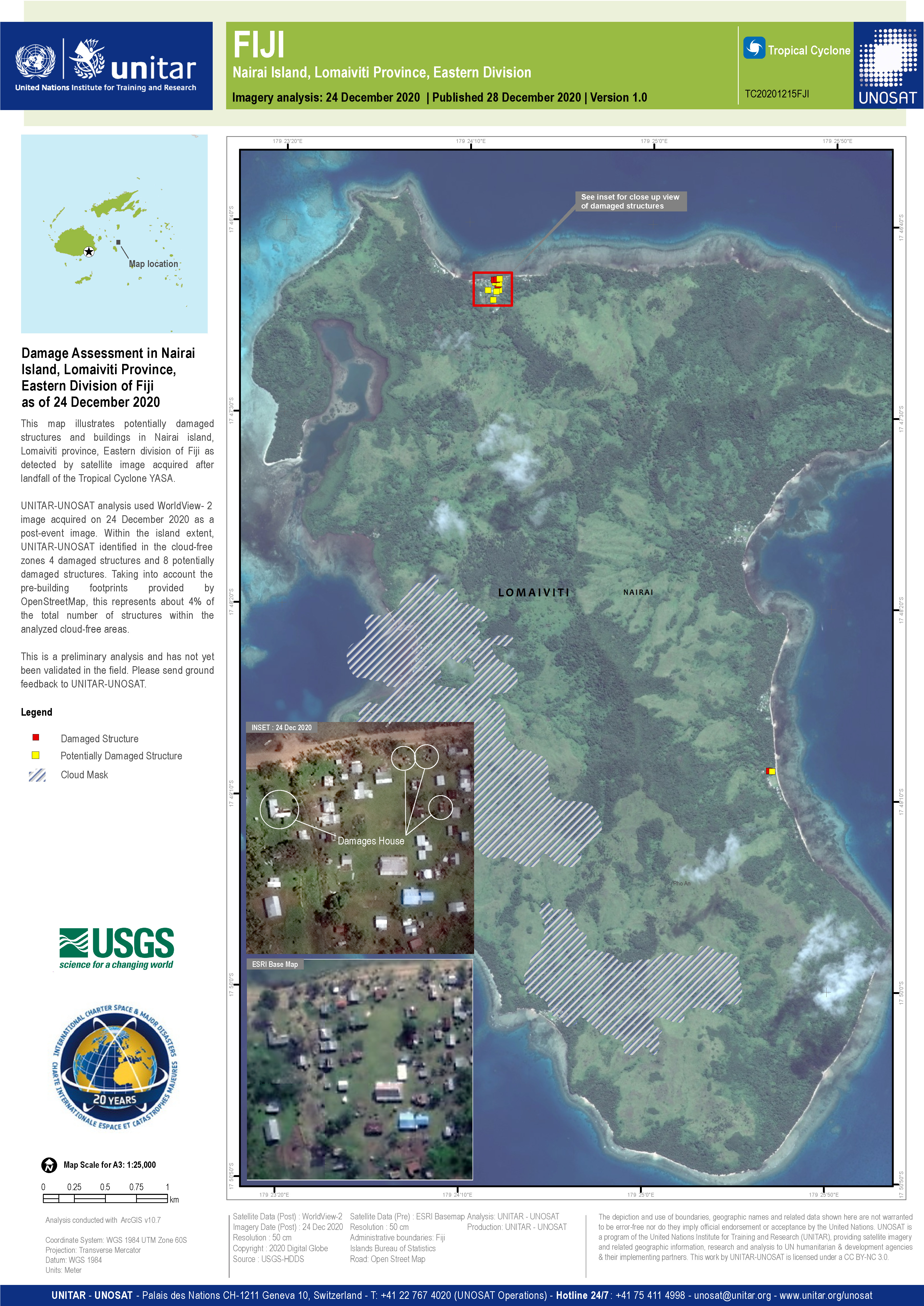
Damage assessment in Nairai Island, Lomaiviti Province, Eastern Division of Fiji
Copyright: © (2020) DigitalGlobe, Inc., Longmont CO USA 80503. DigitalGlobe and the DigitalGlobe logos are trademarks of DigitalGlobe, Inc. The use and/or dissemination of this data and/or of any product in any way derived there from are restricted. Unauthorized use and/or dissemination is prohibited.
Map produced by UNITAR/UNOSAT
Information about the Product
Acquired: 24/12/2020
Source: WorldView-2
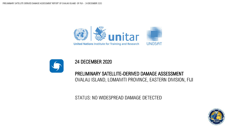
Preliminary satellite-derived damage assessment in Ovalu island, Lomaiviti Province, Eastern Division, Fiji
Download the full report
Copyright: © (2020) DigitalGlobe, Inc., Longmont CO USA 80503. DigitalGlobe and the DigitalGlobe logos are trademarks of DigitalGlobe, Inc. The use and/or dissemination of this data and/or of any product in any way derived there from are restricted. Unauthorized use and/or dissemination is prohibited.
Report produced by UNITAR/UNOSAT
Information about the Product
Acquired: 22/12/2020
Source: WorldView-2
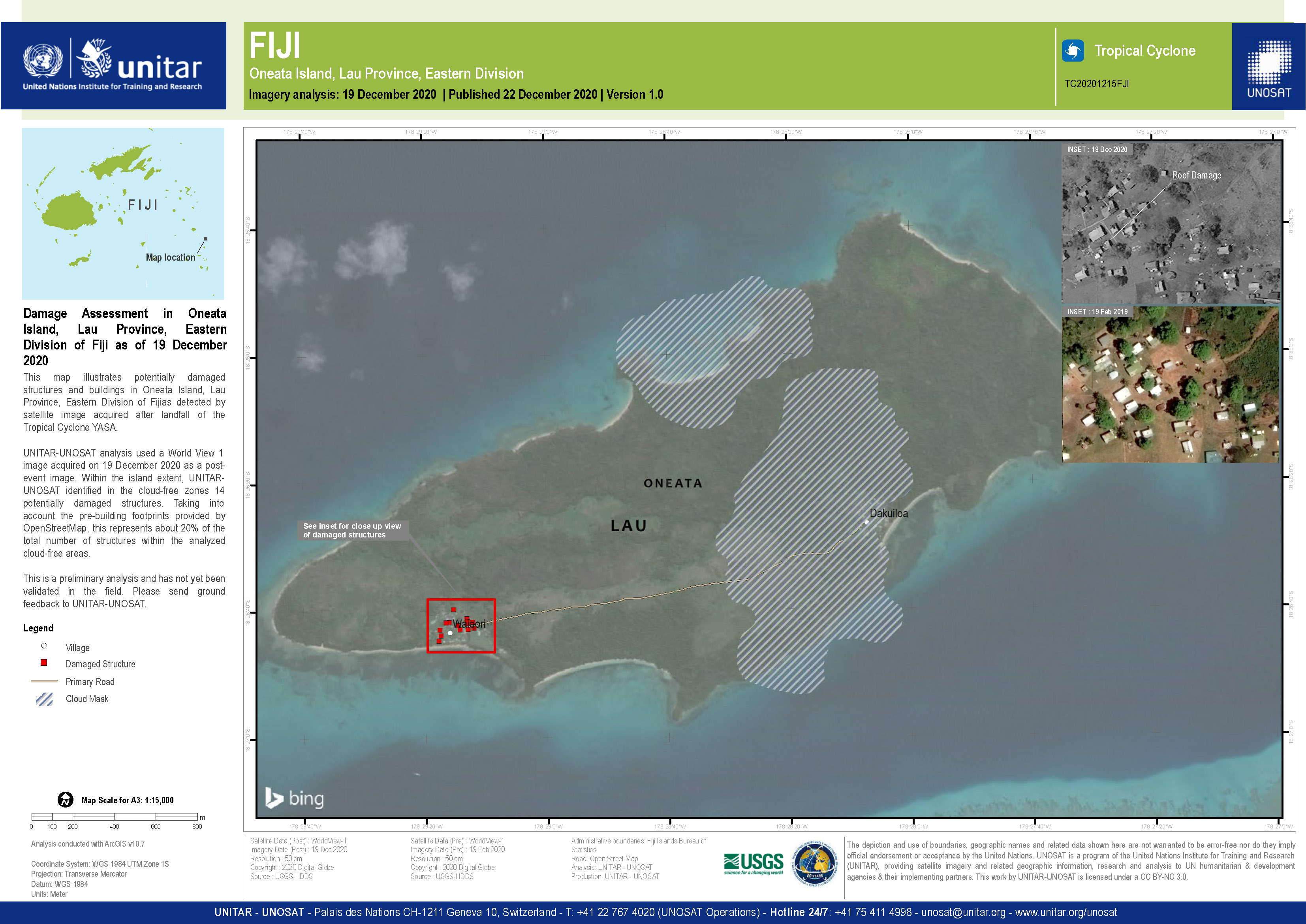
Damage assessment in Oneata Island, Lau Province, Eastern Division of Fiji
Copyright: © (2020) DigitalGlobe, Inc., Longmont CO USA 80503. DigitalGlobe and the DigitalGlobe logos are trademarks of DigitalGlobe, Inc. The use and/or dissemination of this data and/or of any product in any way derived there from are restricted. Unauthorized use and/or dissemination is prohibited.
Map produced by UNITAR/UNOSAT
Information about the Product
Acquired: 19/12/2020
Source: WorldView-1

Preliminary satellite-derived damage assessment, Central, Western and Northern Divisions, Fiji
Download the full report
Copyright: Includes Pleiades material © CNES (2020), Distribution Airbus DS.
Report produced by UNITAR/UNOSAT
Information about the Product
Acquired: 19/12/2020
Source: Pleiades

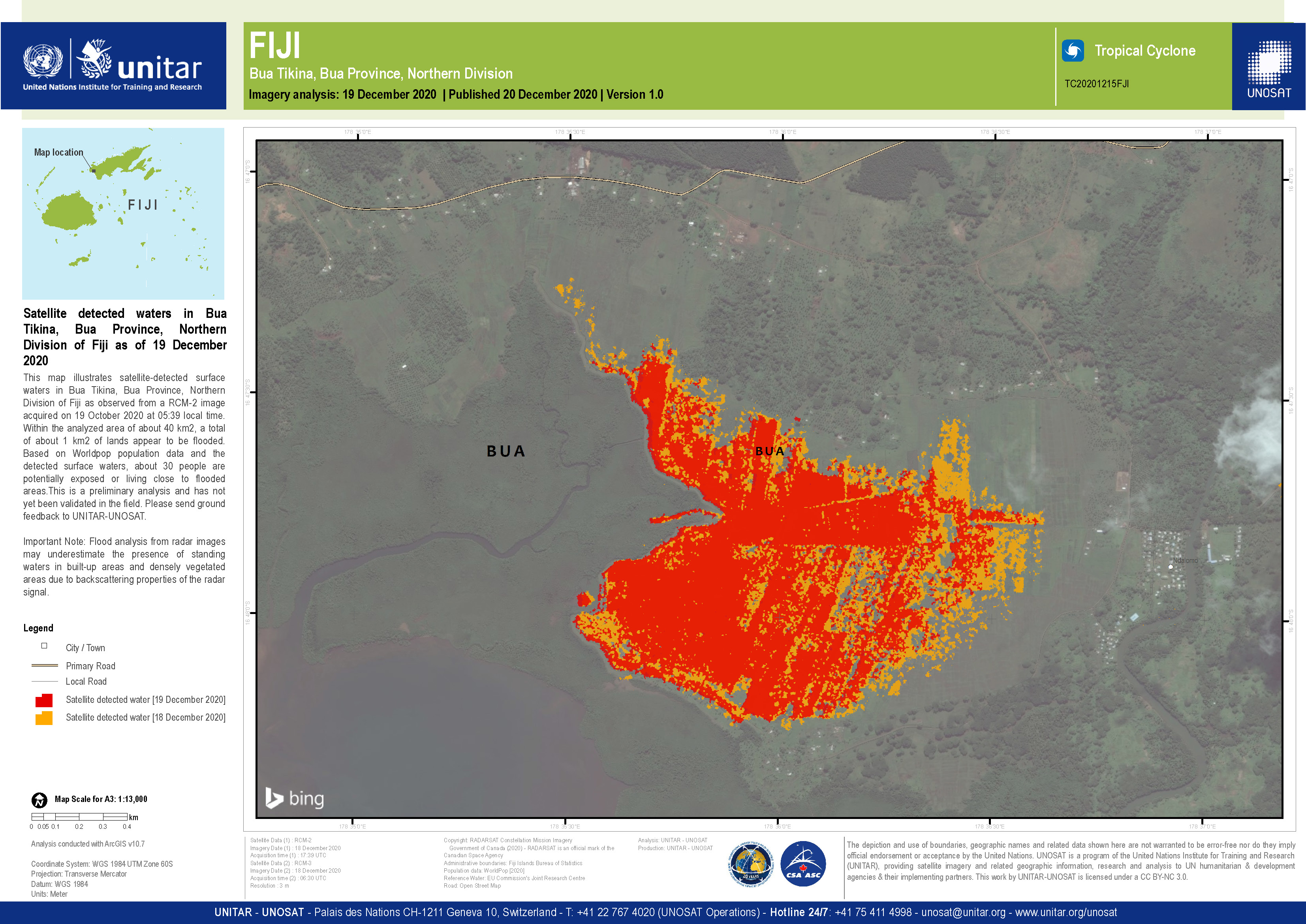
Satellite detected waters in Bua Tikina, Bua Province, Northern Division of Fiji
Copyright: RADARSAT Constellation Mission Imagery © Government of Canada (2020) - RADARSAT is an official mark of the Canadian Space Agency
Map produced by UNITAR/UNOSAT
Information about the Product
Acquired: 18/12/2020
Source: RCM
 Back to the full activation archive

