 English
 Spanish
 French
 Chinese
 Russian
 Portuguese
 Latest Activation
Charter activations
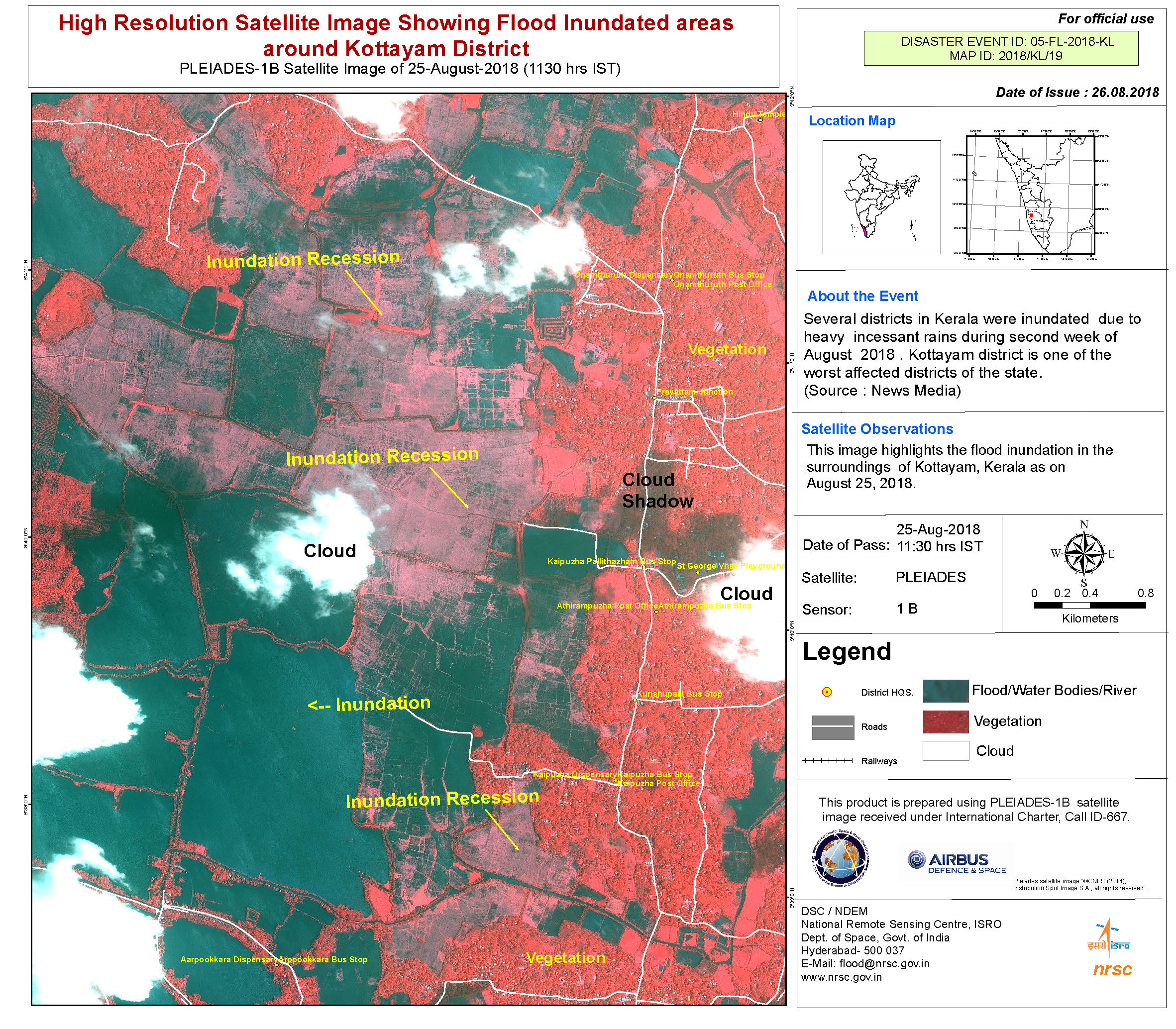
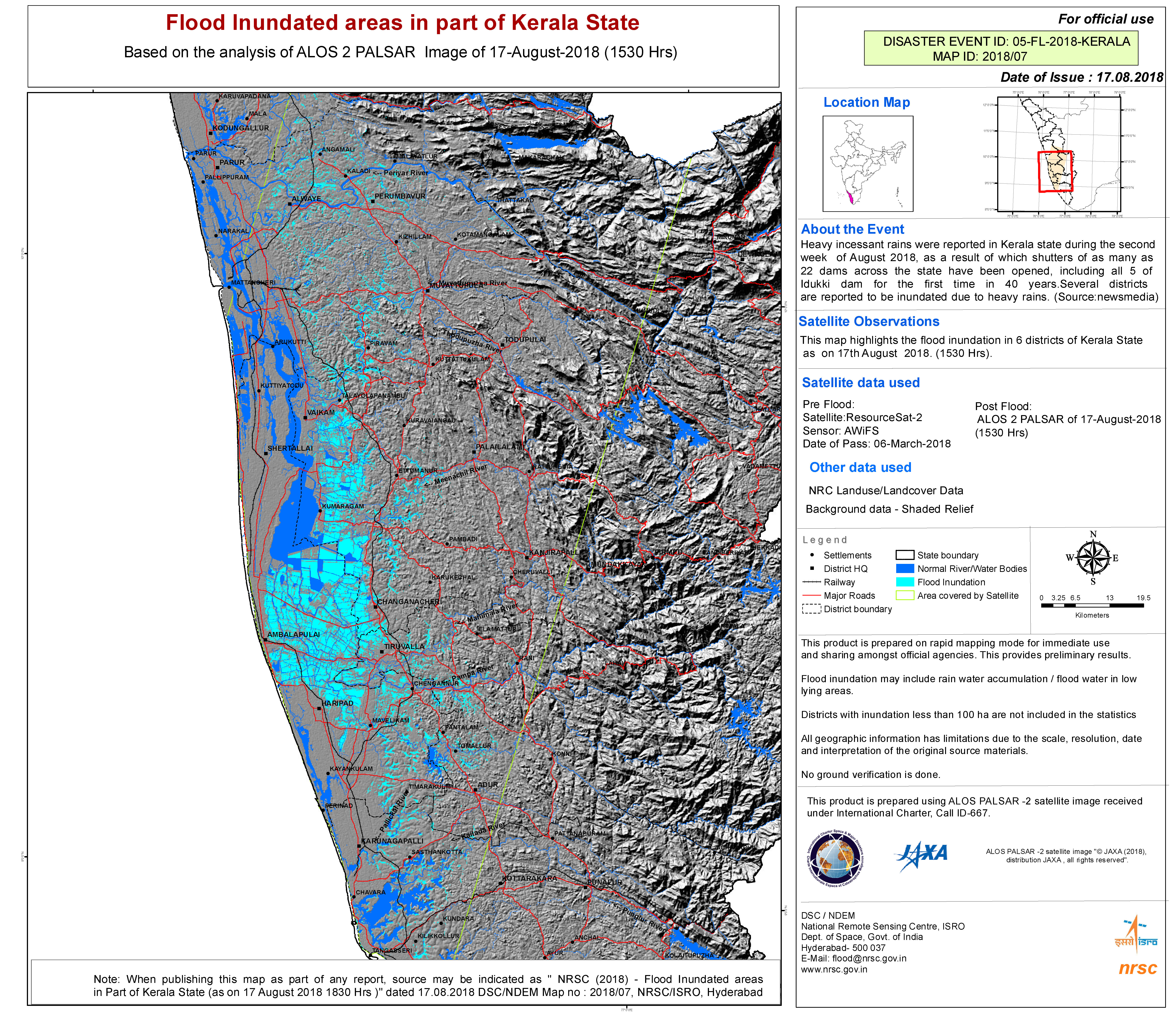
Flood in Kerala State, India
The worst floods in almost a century have hit the southern Indian state of Kerala, killing at least 79 people and displacing thousands. Landslides and bridge collapses have been reported, as well as hundreds of homes and crop fields that have been destroyed.
The Cochin International Airport has also been closed due to excessive water on site. Schools in all 14 districts of Kerala have been closed and some districts are preventing tourists from visiting amid safety concerns.
Rescue operations are under way with the federal government sending additional forces to assist in relief efforts.
India's Metrological Department has forecast heavy rain in Kerala for the next two days, and has issued a red alert for 12 out of its 14 districts.
Related News and Resources
- A Flood for the Century in India (NASA)
- Centre releases Rs.600 crore assistance to flood-affected Kerala (Government of India)
- 5 ISRO satellites come to rescue of flood-hit Kerala (Times of India)
- Before and After the Kerala Floods (NASA)
| Type of Event: | Flood |
| Location of Event: | India |
| Date of Charter Activation: | 2018-08-16 |
| Time of Charter Activation: | 15:33 |
| Time zone of Charter Activation: | UTC+05:30 |
| Charter Requestor: | ISRO |
| Activation ID: | 582 |
| Project Management: | National Remote Sensing Centre |
Products

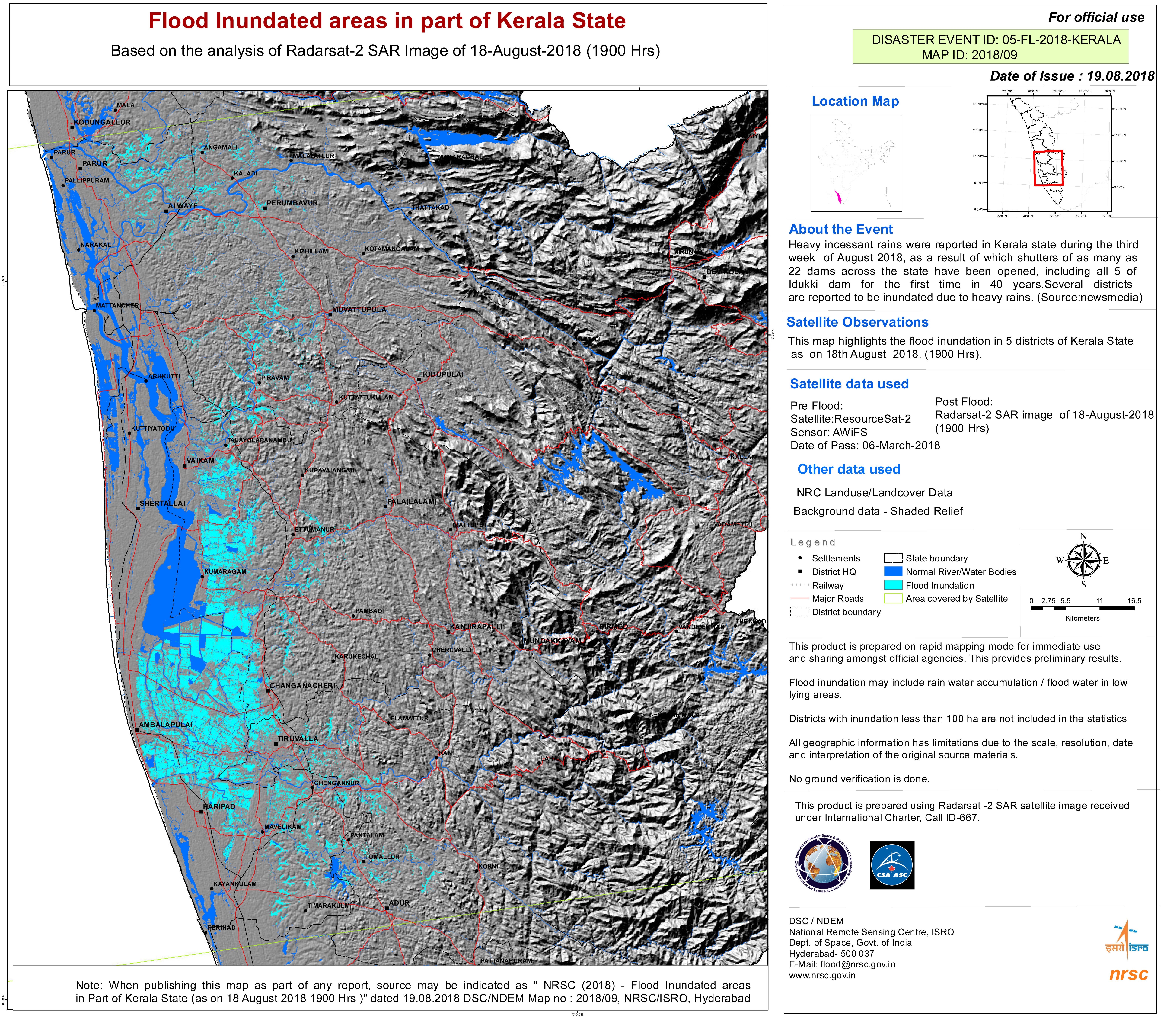
Flood areas in Kerala State, India
Copyright: ResourceSat-2 data and products © ISRO (2018) - All rights reserved
Sentinel-1 © Copernicus Sentinel data (2018)
Map produced by NRSC/ISRO
Information about the Product
Acquired: ResourceSat-2: 06/03/2018
Sentinel-1: 27/08/2018
Source: ResourceSat-2 / Sentinel-1


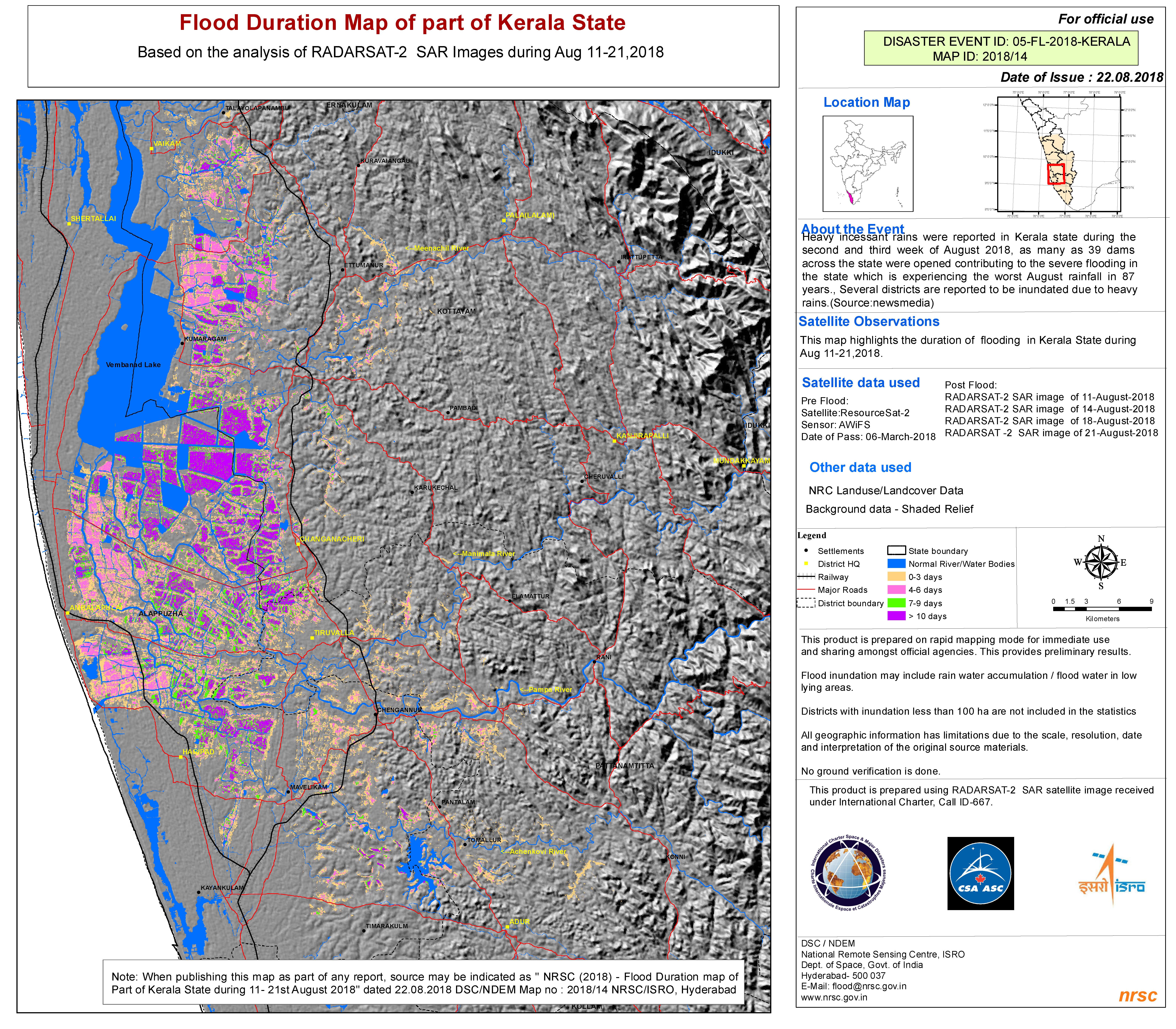
Flood duration map of Kerala State, India
Copyright: ResourceSat-2 data and products © ISRO (2018) - All rights reserved
RADARSAT-2 Data and Products © Maxar Technologies Ltd. (2018) - All Rights Reserved. RADARSAT is an official trademark of the Canadian Space Agency.
Map produced by NRSC/ISRO
Information about the Product
Acquired: ResourceSat-2: 06/03/2018
RADARSAT-2: 11/08/2018, 14/08/2018, 18/08/2018 and 21/08/2018
Source: ResourceSat-2 / RADARSAT-2
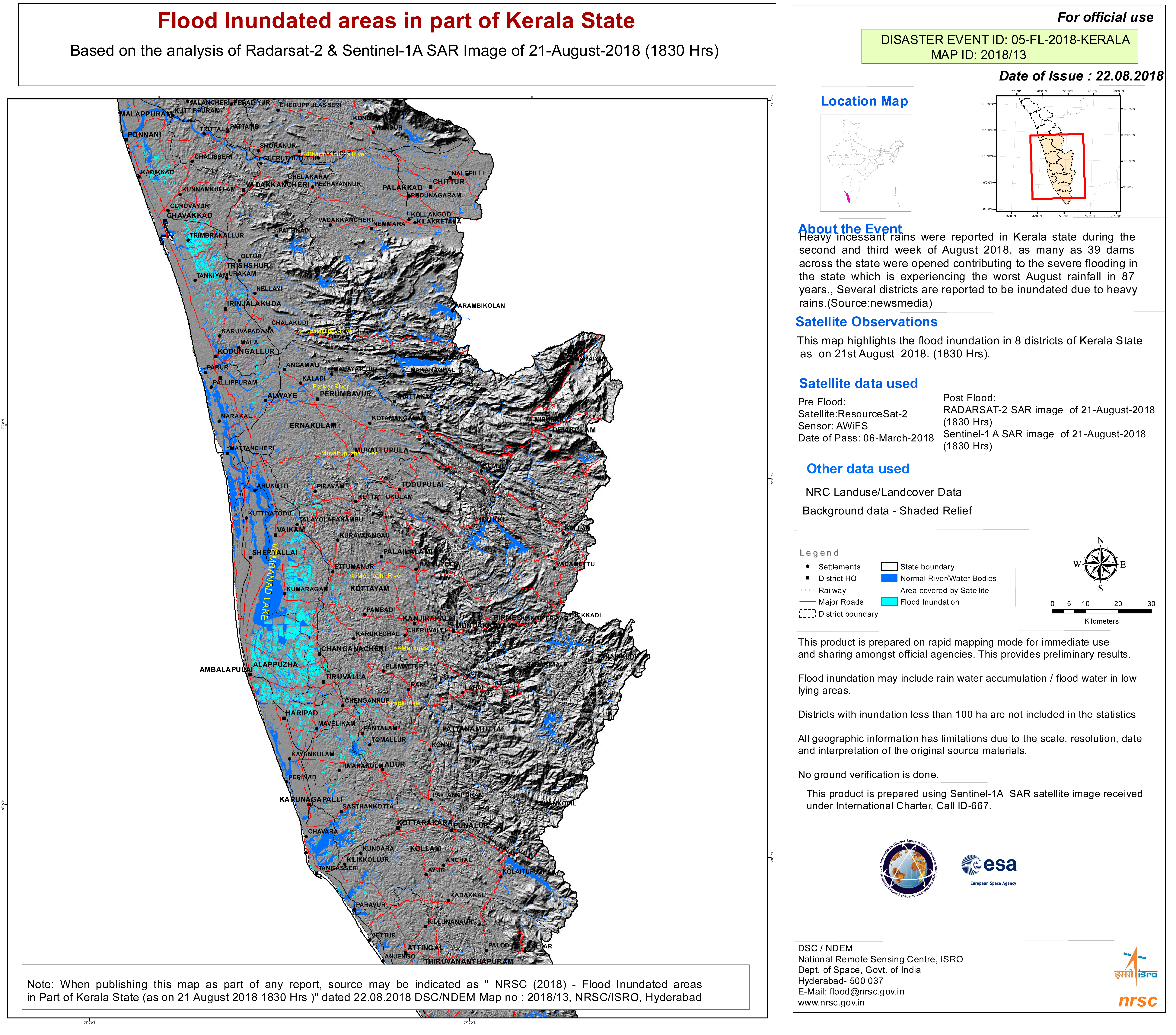
Flood areas in Kerala State, India
Copyright: ResourceSat-2 data and products © ISRO (2018) - All rights reserved
RADARSAT-2 Data and Products © Maxar Technologies Ltd. (2018) - All Rights Reserved. RADARSAT is an official trademark of the Canadian Space Agency.
Sentinel-1 © Copernicus Sentinel data (2018)
Map produced by NRSC/ISRO
Information about the Product
Acquired: ResourceSat-2: 06/03/2018
RADARSAT-2: 21/08/2018
Sentinel-1: 21/08/2018
Source: ResourceSat-2 / RADARSAT-2 / Sentinel-1


 Back to the full activation archive

