Charter activations
Flood in Canada
The Canadian city of Montreal was hit by heavy flooding on 6 May, due to torrential rains and melting snow following the rise in temperature. As a result, a state of emergency was announced and 1,900 homes have been flooded across 126 towns and cities in the east of Canada, across the province of Quebec. It has been confirmed by the local authorities that this safety measure will remain in place for about 48 hours.
Furthermore, this flooding not only affected the east of Montreal, but it also has its footprints on the west of Montreal. As a result, an emergency has been declared in the town of Rigaud and an order of evacuation has been issued by the mayor in the flood zones.
Besides Quebec, the province of Ontario has also been significantly affected by flooding caused by heavy rainfall. In southern Ontario, the Canadian Press news agency has confirmed that Lake Ontario's water level has reached an extent not seen since 1993.
| Type of Event: | Flood |
| Location of Event: | Canada |
| Date of Charter Activation: | 6 May 2017 |
| Time of Charter Activation: | 14:59:00 |
| Time zone of Charter Activation: | UTC-04:00 |
| Charter Requestor: | Public Safety Canada |
| Activation ID: | 529 |
| Project Management: | Canadian Space Agency |
Products

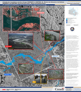
Flood extent on the Ottawa and Gatineau Rivers in Ottawa
Copyright: RADARSAT-2 Data and Products © MacDonald, Dettwiler and Associates Ltd. (2017) - All Rights Reserved. RADARSAT is an official trademark of the Canadian Space Agency.
Sentinel-1 © Copernicus Sentinel data (2017)
Pleiades © CNES (2017) - Distribution: Airbus Defence and Space, all rights reserved
Map produced by Natural Resources Canada
Information about the Product
Acquired: RADARSAT-2: 09/05/2017
Sentinel-1B: 10/05/2017
Pleiades: 10/05/2017
Source: RADARSAT-2 / Sentinel-1B / Pleiades

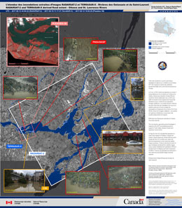
Flood extent on the Ottawa and St. Lawrence Rivers in Montreal
Copyright: RADARSAT-2 Data and Products © MacDonald, Dettwiler and Associates Ltd. (2017) - All Rights Reserved. RADARSAT is an official trademark of the Canadian Space Agency.
TerraSAR-X © DLR e. V. 2017, Distribution: Airbus DS Geo GmbH
Pleiades © CNES (2017) - Distribution: Airbus Defence and Space, all rights reserved
Map produced by Natural Resources Canada
Information about the Product
Acquired: RADARSAT-2: 13/05/2017
TerraSAR-X: 10/05/2017
Pleiades: 12/05/2017
Source: RADARSAT-2 / TerraSAR-X / Pleiades
 Back to the full activation archive

 English
 Spanish
 French
 Chinese
 Russian
 Portuguese


