 English
 Spanish
 French
 Chinese
 Russian
 Portuguese
 Latest Activation
Charter activations
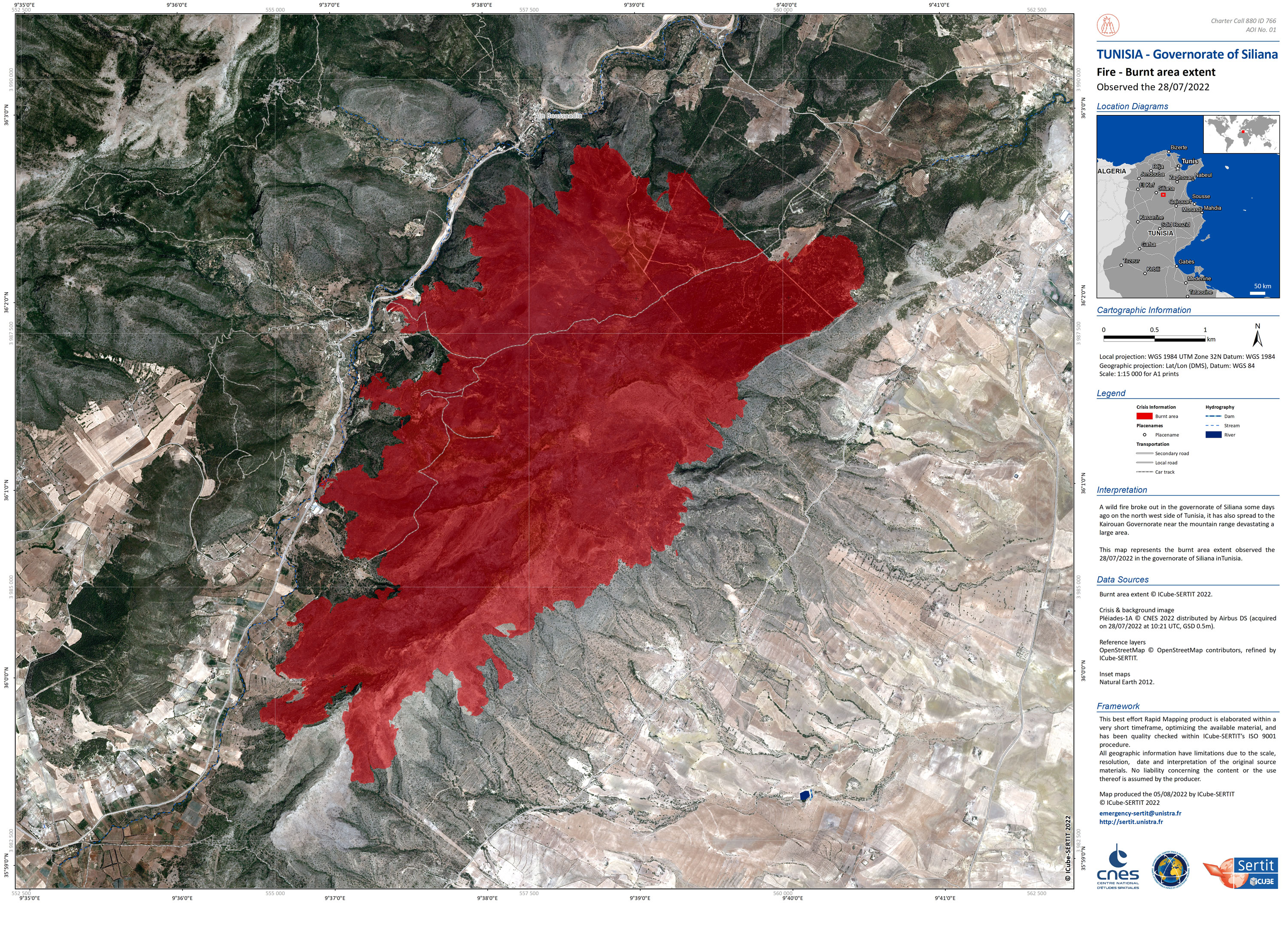
Wildfire in Tunisia
A wild fire broke out in the governorate of Siliana on the north west side of Tunisia, it spread to the Kairouan Governorate near the mountain range devastating a large area.
| Type of Event: | Fires |
| Location of Event: | Tunisia |
| Date of Charter Activation: | 2022-07-27 |
| Time of Charter Activation: | 19:00 |
| Time zone of Charter Activation: | UTC+01:00 |
| Charter Requestor: | Tunisian Office of Civil Protection Office National de la Protection Civile (ONPC) |
| Activation ID: | 766 |
| Project Management: | ICube-SERTIT |
Products


Detected burnt are Siliana Governora, Kairouan Governorate, in north west Tunisia
Copyright: © (2022) DigitalGlobe, Inc., Longmont CO USA 80503. DigitalGlobe and the DigitalGlobe logos are trademarks of DigitalGlobe, Inc. The use and/or dissemination of this data and/or of any product in any way derived there from are restricted. Unauthorized use and/or dissemination is prohibited
Map produced by UE "Geoinformation Systems"
Information about the Product
Acquired: 29/07/2022
Source: WorldView-2
Category: Delineation Map


Detected burnt area in Tunisia
Copyright: USGS/NASA Landsat Program
Contains modified Copernicus Sentinel data (2022)
Map produced by UE "Geoinformation Systems"
Information about the Product
Acquired: Landsat 9: 28/07/2022
Sentinel-2: 29/07/2022
Source: Landsat 9 / Sentinel-2
Category: Delineation Map

Detected burnt area in Tunisia
Copyright: USGS/NASA Landsat Program
Contains modified Copernicus Sentinel data (2022)
Map produced by UE "Geoinformation systems
Information about the Product
Acquired: Landsat 8: 27/07/2022
Sentinel-2: 24/07/2022
Landsat 9: 28/07/2022
Source: Landsat 8 / Sentinel-2 / Landsat 9
Category: Delineation Map
 Back to the full activation archive

