Minimize Latest Activation

Charter activations

Earthquake in Japan

Earthquake hits north-east of Japan causing extensive damage, triggering a tsunami. The earthquake scaled at a magnitude of 8.9 which sparked fires in Tokyo. Many casualties are also feared.

View the NGA Urban Search and Rescue Atlas for products related to this event


Type of Event:Earthquake/Tsunami
Location of Event:Japan
Date of Charter Activation:11/03/2011
Charter Requestor:JAXA - Cabinet Office JAPAN
Project Management:Asian Institute of Technology (AIT)

Products

Breakwater destruction - Kamaishi

Copyright: Spot Image
Map produced by JAXA

Information about the Product

Acquired: Post-disaster: 13/03/2011

Source: SPOT-5

The Liquefaction area - Urayasu bayside area

Copyright: Spot Image
Map produced by JAXA

Information about the Product

Acquired: 13/03/2011

Source: Formosat-2

Great East Japan Earthquake - Shitigahama, Tagajo

Copyright: DigitalGlobe
Map produced by JAXA

Information about the Product

Acquired: 14/03/2011

Source: WorldView-2

Sea Debris - Rikuzentakata, Kesennuma

Copyright: DigitalGlobe
Map produced by JAXA

Information about the Product

Acquired: 20/03/2011

Source: WorldView-2

The landslide area - Ohtani mine

Copyright: GeoEye
Map produced by JAXA

Information about the Product

Acquired: 13/03/2011

Source: GeoEye-1

Sea Debris - Yamada

Copyright: DigitalGlobe
Map created by JAXA

Information about the Product

Acquired: 14/03/2011

Source: WorldView-2

Tsunami damage - Otsuchi, Kamihei District, Iwate Prefecture - Japan

Copyright: GeoEye
DigitalGlobe
Map produced by Clark Labs, Clark University

Information about the Product

Acquired: Pre-disaster: 01/06/2010; Post-disaster: 14/03/2011

Source: GeoEye-1 and WorldView

Okuma, Fukushima, Japan - Tsunami affected areas - Observed March 16, 2011

Copyright: DigitalGlobe, NASA
Map produced by E-Decider

Information about the Product

Acquired: Pre-disaster: 26/03/2009;
Post-disaster: 16/03/2011

Source: WorldView-1 and QuickBird-2

Minamisoma, Fukushima, Japan - Tsunami affected areas - Overview - Observed March 12, 2011

Copyright: DigitalGlobe, NASA
Map produced by E-Decider

Information about the Product

Acquired: Pre-disaster: 26/06/2010
Post-disaster: 12/03/2011

Source: QuickBird and WorldView

Fukushima Dai-Ichi Nuclear Power Plant - Ohkuma, Fukushima Prefecture, Japan

Copyright: DigitalGlobe and GeoEye
Map produced by Rochester Institute of Technology

Information about the Product

Acquired: 17/03/2011 and 19/03/2011

Source: WorldView-2 and GeoEye-1

Tsunami affected areas - Minamisanriku, Japan - Maximum tsunami inundation as mapped by debris fields and ground damage

Copyright: DigitalGlobe
Map produced by USGS

Information about the Product

Acquired: Pre-disaster: 11/03/2011;
Post-disaster: 14/03/2011

Source: WorldView-1

Japan - Tsunami affected areas - Tagajyou (Tagajo)

Copyright: DigitalGlobe
Map produced by George Mason University

Information about the Product

Acquired: Pre-disaster: 04/08/2010;
Post-disaster: 14/03/2011

Source: WorldView-2

Tsunami affected areas - Miyako-shi, Japan

Copyright: DigitalGlobe - Map produced by GISCorps, Auburn University at Montgomery

Information about the Product

Acquired: Pre-disaster: 11/03/11; Post-disaster: 19/03/11

Source: WorldView-1

Tsunami affected areas - Rikuzentakata - Iwate Prefecture, Japan

Copyright: GeoEye, NASA
Map produced by ImageCat

Information about the Product

Acquired: Pre-disaster: 29/09/2010;
Post-disaster: 13/03/2011

Source: GeoEye-1

Japan - Tsunami affected areas: Onagawamachi, Miyagi Prefecture

Copyright: DigitalGlobe
Map produced by Clark Labs, Clark University

Information about the Product

Acquired: Pre-disaster: 11/03/2011;
Post-disaster: 14/03/2011

Source: WorldView-1

Japan - Details of Tsunami affected areas (Shichigahama-machi, Miyagi Prefecture)

Copyright: DigitalGlobe
Map produced by Pennsylvania State University

Information about the Product

Acquired: 14/03/2011

Source: WorldView-2

Earthquake/Tsunami affected area - Miyagi Prefecture, Japan

Copyright: CNES
Map produced by AIT

Information about the Product

Acquired: 12/03/2011

Source: SPOT

Earthquake/Tsunami affected area - Iwate Prefecture, Japan

Copyright: CNES - Map produced by AIT

Information about the Product

Acquired: 14/03/2011

Source: SPOT

Japan - Tsunami affected areas (Ofunato)

Copyright: GeoEye
DigitalGlobe
Map produced by George Mason University

Information about the Product

Acquired: Pre-disaster: 29/09/2010; Post-disaster: 13/03/2011

Source: GeoEye-1 and WorldView-2

Japan - Tsunami affected areas (Rikuzentakata)

Copyright: GeoEye
DigitalGlobe
Map produced by George Mason University

Information about the Product

Acquired: Pre-disaster: 29/09/2010 and 02/01/2011;
Post-disaster: 13/03/2011

Source: GeoEye-1 and WorldView-2

Tsunami affected areas - Rikuzen-Koizumi, Miyagi, Japan

Copyright: DigitalGlobe
Map produced by USGS

Information about the Product

Acquired: Pre-disaster: 11/03/2011;
Post-disaster: 14/03/2011

Source: WorldView-1

Tsunami-related standing water bodies - Sendai, Miyagi Prefecture, Japan

Copyright: RADARSAT-2 Data and Products © MacDonald, Dettwiler and Associates Ltd.(2011) - All Rights Reserved. RADARSAT is an official trademark of the Canadian Space Agency.
Map produced by UNITAR/UNOSAT

Information about the Product

Acquired: Pre-disaster: 26/03/2006;
Post-disaster: 12/03/2011

Source: RADARSAT-1 and RADARSAT-2

Japan - Honshu - Tsunami - Estimated directly affected inhabitants by tsunami inundation as of March 12, 2011

Copyright: DLR, Landscan
Map produced by ZKI

Information about the Product

Acquired: 12/03/2011

Source: TerraSAR-X

Japan - Tsunami affected areas - Rikuzentakata (Osabe fishing port)

Copyright: USGS
Map produced by AIT

Information about the Product

Acquired: Pre-disaster: 02/01/2010;
Post-disaster: 13/03/2011

Source: WorldView-1 and WorldView-2

Japan - Tsunami affected areas (Ofunatocho)

Copyright: USGS
Map produced by AIT

Information about the Product

Acquired: Pre-disaster: 23/07/2010;
Post-disaster: 13/03/2011

Source: GeoEye

Japan Earthquake/Tsunami - Iwaki City, Fukushima

Copyright: RapidEye AG and GeoEye
Map produced by JAXA

Information about the Product

Acquired: 12/03/2011

Source: RapidEye and IKONOS

M9.0 Japan Earthquake/Tsunami of March 11, 2011 - Nakoso, Fukushima

Copyright: © BlackBridge AG - All rights reserved
Map produced by JAXA

Information about the Product

Acquired: Pre-disaster: 21/05/2010;
Post-disaster: 12/03/2011

Source: RapidEye

Japan - Tsunami affected areas - Minami Sohma (The mouth of Manogawa)

Copyright: USGS - Map produced by AIT

Information about the Product

Acquired: Pre-disaster: 26/06/2010;
Post-disaster: 14/03/2011

Source: WorldView-2 and Quickbird

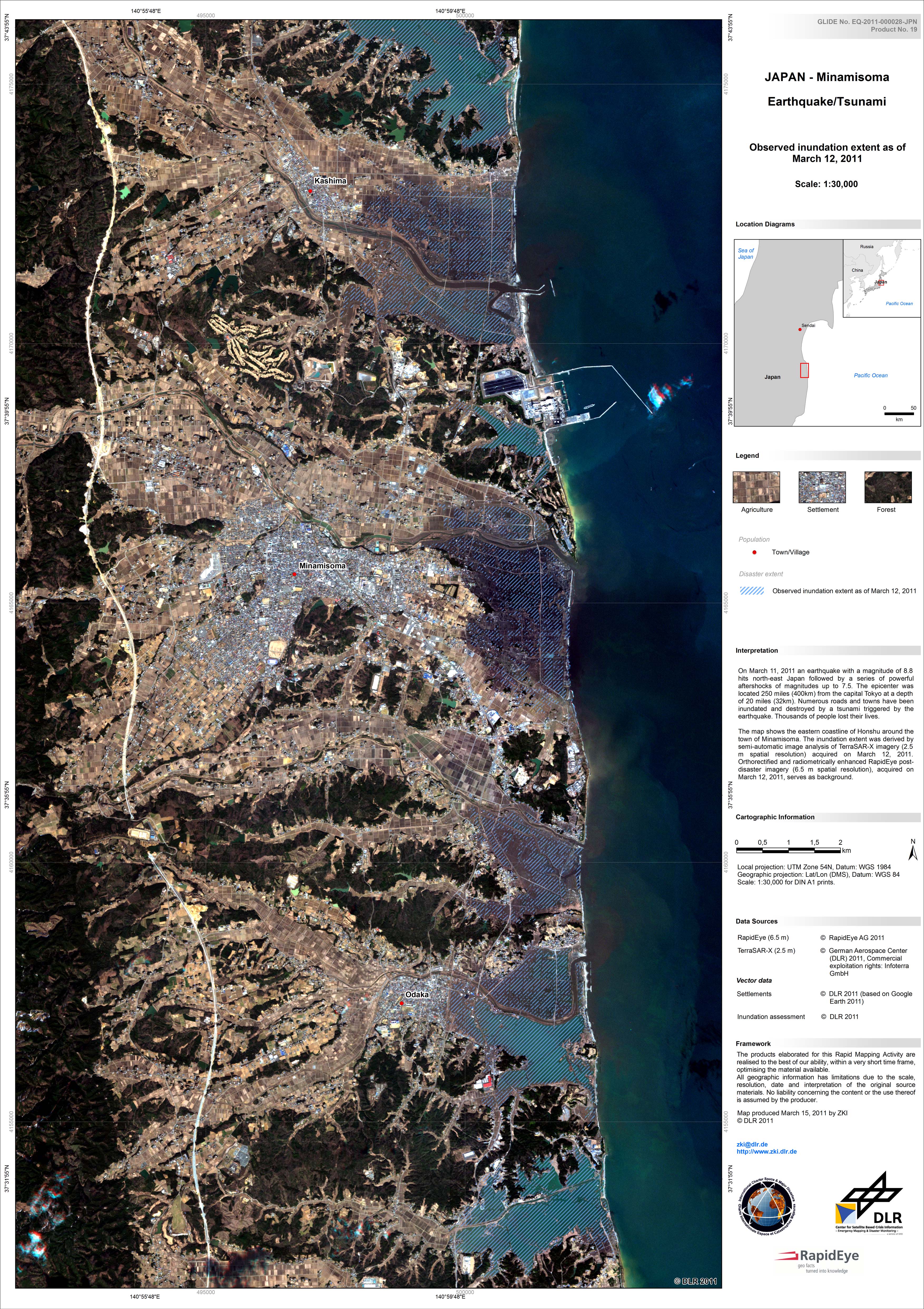
Tsunami affected areas 2011 - Sendai, Japan

Copyright: USGS - Map produced by AIT - RADARSAT-2 Data and Products © MacDonald, Dettwiler and Associates Ltd.(2011) - All Rights Reserved. RADARSAT is an official trademark of the Canadian Space Agency.

Information about the Product

Acquired: Pre-disaster: 26/03/2006; Post-disaster: 12/03/2011

Source: RADARSAT-2, WorldView

Japan - Sendai region - Overview Map - Observed inundation extent as of March 12, 2011

Copyright: DLR
Map produced by ZKI

Information about the Product

Acquired: 12/03/2011

Source: TerraSAR-X

Coverage of high resolution imagery for earthquake/tsunami affected area, Japan

Copyright: Map produced by AIT

Information about the Product

Acquired: 16/03/2011

Source: RapidEye, IKONOS, GeoEye, WorldView, QuickBird and SPOT satellites

Japan - Tsunami affected areas (Ishinomaki Port)

Copyright: USGS - Map produced by AIT

Information about the Product

Acquired: Pre-disaster: 27/01/2011;
Post-disaster: 12/03/2011

Source: IKONOS and WorldView-1

Japan - Tsunami affected areas (The mouth of Kyu-Kita Kamigawa)

Copyright: USGS - Map produced by AIT

Information about the Product

Acquired: Pre-disaster: 27/01/2011;
Post-disaster: 12/03/2011

Source: IKONOS and WorldView-1

RapidEye imagery - Ogatu, Ishinomaki - Miyagi Prefecture

Copyright: RapidEye AG
Map produced by JAXA

Information about the Product

Acquired: Pre-disaster: 05/09/2010;
Post-disaster: 13/03/2011

Source: RapidEye

RapidEye imagery - Onagawa, Miyagi Prefecture

Copyright: RapidEye AG
Map produced by JAXA

Information about the Product

Acquired: Pre-disaster: 05/09/2010
Post-disaster: 13/03/2011

Source: RapidEye

RapidEye imagery - Minamisanriku (IV), Miyagi Prefecture

Copyright: RapidEye AG
Map produced by JAXA

Information about the Product

Acquired: Pre-disaster: 05/09/2010;
Post-disaster: 13/03/2011

Source: RapidEye

RapidEye imagery - Minamisanriku (II), Miyagi Prefecture

Copyright: RapidEye AG
Map produced by JAXA

Information about the Product

Acquired: Pre-disaster: 05/09/2010;
Post-disaster: 13/03/2011

Source: RapidEye

RapidEye imagery - Minamisanriku (III), Miyagi Prefecture

Copyright: RapidEye AG
Map produced by JAXA

Information about the Product

Acquired: Pre-disaster: 05/09/2010;
Post-disaster: 13/03/2011

Source: RapidEye

RapidEye imagery - Kamaishi, Iwate Prefecture

Copyright: RapidEye AG
Map produced by JAXA

Information about the Product

Acquired: Pre-disaster: 05/09/2010;
Post-disaster: 13/03/2011

Source: RapidEye

RapidEye imagery - Kamaishi (II), Iwate Prefecture

Copyright: RapidEye AG
Map produced by JAXA

Information about the Product

Acquired: Pre-disaster: 05/09/2010;
Post-disaster: 13/03/2011

Source: RapidEye

RapidEye imagery - Ohtuchi, Iwate Prefecture

Copyright: RapidEye AG
Map produced by JAXA

Information about the Product

Acquired: Pre-disaster: 05/09/2010;
Post-disaster: 13/03/2011

Source: RapidEye

RapidEye imagery - Yamada (II), Iwate Prefecture

Copyright: RapidEye AG
Map produced by JAXA

Information about the Product

Acquired: Pre-disaster: 05/09/2010;
Post-disaster: 13/03/2011

Source: RapidEye

RapidEye imagery - Yamada (I), Iwate Prefecture

Copyright: RapidEye AG
Map produced by JAXA

Information about the Product

Acquired: Pre-disaster: 05/09/2010;
Post-disaster: 13/03/2011

Source: RapidEye

RapidEye imagery - Miyako, Iwate Prefecture

Copyright: RapidEye AG
Map produced by JAXA

Information about the Product

Acquired: Pre-disaster: 05/09/2010;
Post-disaster: 13/03/2011

Source: RapidEye

RapidEye imagery - Tarou, Miyako - Iwate Prefecture

Copyright: RapidEye AG
Map produced by JAXA

Information about the Product

Acquired: Pre-disaster: 05/09/2010;
Post-disaster: 13/03/2011

Source: RapidEye

RapidEye imagery - Ofunato, Iwate Prefecture

Copyright: RapidEye AG
Map produced by JAXA

Information about the Product

Acquired: Pre-disaster: 05/09/2010;
Post-disaster: 13/03/2011

Source: RapidEye

RapidEye imagery - Sanriku, Ofunato - Iwate Prefecture

Copyright: RapidEye AG
Map produced by JAXA

Information about the Product

Acquired: Pre-disaster: 05/09/2010;
Post-disaster: 13/03/2011

Source: RapidEye

RapidEye imagery - Rikuzentakata, Iwate Prefecture

Copyright: RapidEye AG
Map produced by JAXA

Information about the Product

Acquired: Pre-disaster: 05/09/2010;
Post-disaster: 13/03/2011

Source: RapidEye

RapidEye imagery - Minamisanriku, Miyagi Prefecture

Copyright: RapidEye AG
Map produced by JAXA

Information about the Product

Acquired: Pre-disaster: 05/09/2010;
Post-disaster: 13/03/2011

Source: RapidEye

RapidEye imagery - Higashimatsushima, Miyagi Prefecture

Copyright: RapidEye AG
Map produced by JAXA

Information about the Product

Acquired: Pre-disaster: 05/09/2010;
Post-disaster: 13/03/2011

Source: RapidEye

RapidEye imagery - Kitakami-gawa, Miyagi Prefecture

Copyright: RapidEye AG
Map produced by JAXA

Information about the Product

Acquired: Pre-disaster: 05/09/2010;
Post-disaster: 13/03/2011

Source: RapidEye

RapidEye imagery - Ogatu Wan, Miyagi Prefecture

Copyright: RapidEye AG
Map produced by JAXA

Information about the Product

Acquired: Pre-disaster: 05/09/2010;
Post-disaster: 13/03/2011

Source: RapidEye

Japan - Minamisoma - Observed inundation extent as of March 12, 2011

Copyright: RapidEye, DLR
Map produced by ZKI

Information about the Product

Acquired: 12/03/2011

Source: RapidEye and TerraSAR-X

Japan - Honshu Island - Sendai Airport - Situation the 14th of March 2011

Copyright: Digital Globe, OpenStreetMap
Map produced by SERTIT

Information about the Product

Acquired: 14/03/2011

Source: WorldView-2 and OpenStreetMap

Japan - Honshu Island - Sendai Airport - Detailed reference map - Situation the 4th of August 2010

Copyright: GeoEye, OpenStreetMap
Map produced by SERTIT

Information about the Product

Acquired: 04/08/2010

Source: Ikonos, OpenStreetMap

Japan - Honshu Island - Coastline - Minamisanriku - Hashikami - Tsunami - Highly damaged areas

Copyright: CNES, Spot Image, USGS, ESRI
Map produced by SERTIT

Information about the Product

Acquired: 13/03/2011 and 21/09/2000

Source: SPOT-5 and Landsat 7

Japan - Miyagi - Observed inundation extent as of March 12, 2011

Copyright: RapidEye, DLR - Map produced by ZKI

Information about the Product

Acquired: 05/09/2010 and 12/03/2011

Source: RapidEye and TerraSAR-X

Earthquake/Tsunami affected area (Iwanuma, South of Sendai Airport)

Copyright: IKONOS, USGS
Map produced by AIT

Information about the Product

Acquired: 04/08/2010 and 14/03/2011

Source: IKONOS and WorldView

Tsunami affected area - Sendai, Japan

Copyright: RADARSAT-2 Data and Products © MacDonald, Dettwiler and Associates Ltd.(2011) - All Rights Reserved. RADARSAT is an official trademark of the Canadian Space Agency.
Map produced by AIT

Information about the Product

Acquired: Pre-disaster: 26/03/2006;
Post-dsaster: 12/03/2011

Source: RADARSAT-2

Japan - Tsunami affected areas (Natori / Sendai Airport)

Copyright: USGS, Digital Globe
Map produced by AIT

Information about the Product

Acquired: 12/03/2011

Source: IKONOS

Japan - Honshu Island - Miyako - Hashikami area - Tsunami highly damaged areas

Copyright: CNES, Spot Image, USGS, ESRI
Map produced by SERTIT

Information about the Product

Acquired: 13/03/2011 and 21/09/2000

Source: SPOT-5 and Landsat 7

Japan - Honshu Island - Minamisanriku - Yamada area - Tsunami highly damaged areas

Copyright: CNES, Spot Image, ESRI
Map produced by SERTIT

Information about the Product

Acquired: 13/03/2011

Source: SPOT-5

Japan - Honshu Island - Ofunato area - Tsunami highly damaged areas

Copyright: CNES, Spot Image, ESRI
Map produced by SERTIT

Information about the Product

Acquired: 13/03/2011

Source: SPOT-5

Japan - Honshu Island - Minamisanriku area - Tsunami highly damaged areas

Copyright: CNES, Spot Image, DigitialGlobe, ESRI
Map produced by SERTIT

Information about the Product

Acquired: 11/03/2011-12/03/2011

Source: SPOT-5 and WorldView-1

TerraSAR-X Change Analysis of Sendai area, Japan

Copyright: DLR, LandScan
Map produced by ZKI

Information about the Product

Acquired: Pre-disaster: 20/10/2010;
Post-disaster: 12/03/2011

Source: TerraSAR-X

Japan - Tome - Damage assessment map as of March 14, 2011

Copyright: DigitalGlobe, DLR
Map produced by ZKI

Information about the Product

Acquired: 14/03/2011

Source: WorldView-2

Composite TerraSAR-X imagery of the Coastline of Miyagi Prefecture

Copyright: DLR
Map produced by JAXA

Information about the Product

Acquired: Pre-disaster: 20/10/2010;
Post-disaster: 12/03/2011

Source: TerraSAR-X

TerraSAR-X imagery of the Coastline of Miyagi Prefecture

Copyright: DLR
Map produced by JAXA

Information about the Product

Acquired: Pre-disaster: 20/10/2010;
Post-disaster: 12/03/2011

Source: TerraSAR-X

Coastline of Miyagi Prefecture

Copyright: RapidEye
Map produced by JAXA

Information about the Product

Acquired: Pre-disaster: 05/09/2010;
Post-disaster: 12/03/2011

Source: RapidEye

Japan - Honshu Tsunami - overview inundation assessment as of March 12 and 13, 2011 (sheet 4)

Copyright: RapidEye AG, DLR
Map produced by ZKI

Information about the Product

Acquired: 12/03/2011 - 13/03/2011

Source: RapidEye

Japan - Honshu Tsunami - overview inundation assessment as of March 12 and 13, 2011 (sheet 3)

Copyright: RapidEye AG, DLR
Map produced by ZKI

Information about the Product

Acquired: 12/03/2011 - 13/03/2011

Source: RapidEye

Japan - Honshu Tsunami - overview inundation assessment as of March 12 and 13, 2011 (sheet 2)

Copyright: RapidEye AG, DLR
Map produced by ZKI

Information about the Product

Acquired: 12/03/2011 - 13/03/2011

Source: RapidEye

Japan - Honshu Tsunami - overview inundation assessment as of March 12 and 13, 2011 (sheet 1)

Copyright: RapidEye AG, DLR
Map produced by ZKI

Information about the Product

Acquired: 12/03/2011 - 13/03/2011

Source: RapidEye

Japan - Torinoumi - pre and post disaster

Copyright: RapidEye AG, DLR, Google Earth
Map produced by ZKI

Information about the Product

Acquired: Pre-disaster - 05/09/2010;
Post-disaster - 12/03/2011

Source: RapidEye and TerraSAR-X

Japan - Soma - pre and post disaster

Copyright: RapidEye AG, DLR
Map produced by ZKI

Information about the Product

Acquired: Pre-disaster - 05/09/2010;
Post-disaster - 12/03/2011

Source: RapidEye

Japan - Sendai Airport

Copyright: DigitalGlobe, OpenStreetMap, DLR
Map produced by ZKI

Information about the Product

Acquired: 12/03/2011

Source: WorldView-2

Japan Earthquake as of March 11, 2011

Copyright: ESRI, DLR
Map produced by ZKI

Information about the Product

Acquired: 11/03/2011

Source: ESRI

Japan - Oshika Peninsula

Copyright: DigitalGlobe, DLR
Map produced by ZKI

Information about the Product

Acquired: 12/03/2011

Source: WorldView-2

Japan - Oshika Peninsula - Yagawahama (sheet 5)

Copyright: DigitalGlobe, DLR
Map produced by ZKI

Information about the Product

Acquired: 12/03/2011

Source: WorldView-2

Japan - Oshika Peninsula - Onagawa Nuclear Power Plant (sheet 4)

Copyright: DigitalGlobe, DLR
Map produced by ZKI

Information about the Product

Acquired: 12/03/2011

Source: WorldView-2

Japan - Oshika Peninsula - Momonoura (sheet 3)

Copyright: DigitalGlobe, DLR
Map produced by ZKI

Information about the Product

Acquired: 12/03/2011

Source: WorldView-2

Japan - Oshika Peninsula - Ishinomaki Bay (sheet 2)

Copyright: DigitalGlobe, DLR
Map produced by ZKI

Information about the Product

Acquired: 12/03/2011

Source: WorldView-2

Japan - Oshika Peninsula - Onagawa (sheet 1)

Copyright: DigitalGlobe, DLR
Map produced by ZKI

Information about the Product

Acquired: 12/03/2011

Source: WorldView-2

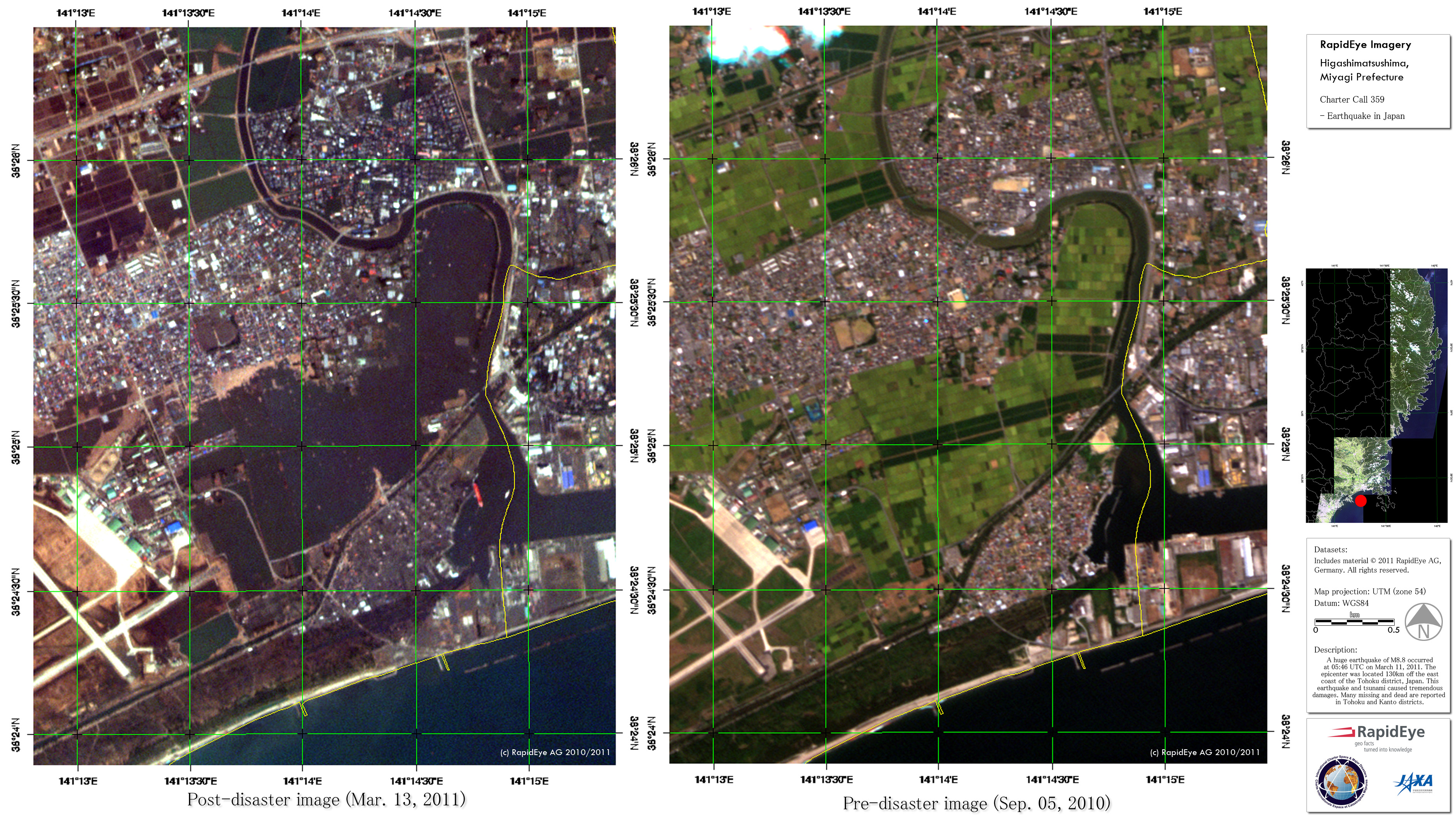
Japan - Higashi-Matsushima - Disaster extent as of March 12, 2011

Copyright: RapidEye, DLR
Map produced by ZKI

Information about the Product

Acquired: Pre-disaster - RapidEye 05/09/2010;
Pre-disaster - TerraSAR-X 19/10/2009;
Post-disaster - RapidEye 12/03/2011;
Post-disaster - TerraSAR-X 12/03/2011

Source: RapidEye and TerraSAR-X

Japan - Honshu Island, Minamisoma - Fukushima area - Tsunami highly damaged areas

Copyright: CNES, Spot Image, USGS, ESRI
Map produced by SERTIT

Information about the Product

Acquired: SPOT-5: 12/03/2011
Landsat 7: 24/09/2001

Source: SPOT-5 and Landsat 7

Japan - Honshu Island, Miyagi area - Tsunami highly damaged areas

Copyright: CNES, SPOT Image, USGS
Map produced by SERTIT

Information about the Product

Acquired: SPOT-5: 12/03/2011
Landsat 7: 21/09/2000

Source: SPOT-5 and Landsat 7

Japan - Honshu Island, Fukushima - Ishinomaki area - Tsunami highly damaged areas

Copyright: CNES, USGS, Google, ESRI
Map produced by SERTIT

Information about the Product

Acquired: SPOT-5: 12/03/2011
Landsat 7: 21/09/2000 and 24/09/2001

Source: SPOT-5 and Landsat 7

Japan - Honshu Island, Sohma area - Tsunami highly damaged areas

Copyright: CNES, SPOT Image, ESRI
Map produced by SERTIT

Information about the Product

Acquired: 12/03/2011

Source: SPOT-5

Japan - Honshu Island, Sendai area - Tsunami highly damaged areas

Copyright: CNES, SPOT Image, ESRI
Map produced by SERTIT

Information about the Product

Acquired: 12/03/2011

Source: SPOT-5

Japan - Honshu Island, Sendai - Sohma areas - Tsunami highly damaged areas

Copyright: CNES, SPOT Image, Google, ESRI
Map produced by SERTIT

Information about the Product

Acquired: 12/03/2011

Source: SPOT-5

Japan - Honshu Island, Misawa area - Potentially affected areas by tsunami

Copyright: USGS, ESRI
Map produced by SERTIT

Information about the Product

Acquired: 21/09/2000

Source: Landsat 7

Japan - Honshu Island, Hachinohe area - Potentially affected areas by tsunami

Copyright: USGS, ESRI
Map produced by SERTIT

Information about the Product

Acquired: 21/09/2000

Source: Landsat 7

Japan - Honshu Island, Miyako area - Potentially affected areas by tsunami

Copyright: USGS, ESRI
Map produced by SERTIT

Information about the Product

Acquired: 21/09/2000

Source: Landsat 7

Japan - Honshu Island, Miyagino area - Potentially affected areas by tsunami

Copyright: USGS, ESRI
Map produced by SERTIT

Information about the Product

Acquired: 21/09/2000 and 24/09/2001

Source: Landsat 7

Back to the full activation archive